Lincoln County, Missouri

Last updated

Lincoln County
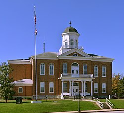
Lincoln County MO Courthouse 20141022 A.jpg
Lincoln County Courthouse in Troy
Map of Missouri highlighting Lincoln County.svg
Location within the U.S. state of Missouri
Missouri in United States.svg
Missouri's location within the U.S.
Coordinates: 39°04′N90°58′W / 39.06°N 90.96°W / 39.06; -90.96
CountryFlag of the United States.svg United States
StateFlag of Missouri.svg  Missouri
FoundedDecember 14, 1818
Named for Benjamin Lincoln
Seat Troy
Largest cityTroy
Area
  Total640 sq mi (1,700 km2)
  Land627 sq mi (1,620 km2)
  Water14 sq mi (40 km2)  2.2%
Population
 (2020)
  Total59,574 Increase2.svg
Time zone UTC−6 (Central)
  Summer (DST) UTC−5 (CDT)
Congressional district 3rd
Website www.lcmo.us
An old barn in rural Lincoln County LuckRdBarn.jpg
An old barn in rural Lincoln County

Lincoln County is located in the eastern part of the U.S. state of Missouri. As of the 2020 census, the population was 59,574. [1] Its county seat is Troy. [2] The county was founded December 14, 1818, and named for Major General Benjamin Lincoln of the American Revolutionary War. [3] Lincoln County is part of the St. Louis, MO-IL Metropolitan Statistical Area.

Contents

History

According to Goodspeed's History of Lincoln County, Missouri (1888), Lincoln County was named by Major Christopher Clark, the first permanent white settler in an address to the Territorial Legislature. He said, "I was born, sir, in Link-Horn County, N.C., I lived for many years in Link-Horn County in old Kain-tuck. I wish to die in Link-Horn County, in Missouri; and I move, therefore, that the blank in the bill be filled with the name Link-Horn." The motion was carried unanimously and the clerk, not adopting the frontier parlance of the Major, wrote "Lincoln" in the blank space of the bill. Others [ who? ] say it was named for Major General Benjamin Lincoln, who served in the Continental Army during the American Revolution.

Geography

According to the U.S. Census Bureau, the county has a total area of 640 square miles (1,700 km2), of which 627 square miles (1,620 km2) is land and 14 square miles (36 km2) (2.2%) is water. [4] The county's eastern border with Illinois is formed by the Mississippi River.

Adjacent counties

Major highways

Transit

Railroads

Demographics

Historical population
CensusPop.Note
1820 1,662
1830 4,059144.2%
1840 7,44983.5%
1850 9,42126.5%
1860 14,21050.8%
1870 15,96012.3%
1880 17,4269.2%
1890 18,3465.3%
1900 18,3520.0%
1910 17,003−7.4%
1920 15,956−6.2%
1930 13,929−12.7%
1940 14,3953.3%
1950 13,478−6.4%
1960 14,7839.7%
1970 18,04122.0%
1980 22,19323.0%
1990 28,89230.2%
2000 38,94434.8%
2010 52,56635.0%
2020 59,57413.3%
U.S. Decennial Census [5]
1790-1960 [6] 1900-1990 [7]
1990-2000 [8] 2010-2020 [9] 2020 [1]

As of the census [10] of 2000, there were 38,944 people, 13,851 households, and 10,554 families residing in the county. The population density was 62 inhabitants per square mile (24/km2). There were 15,511 housing units at an average density of 25 units per square mile (9.7/km2). The racial makeup of the county was 96.13% White, 1.74% Black or African American, 0.37% Native American, 0.17% Asian, 0.03% Pacific Islander, 0.43% from other races, and 1.14% from two or more races. Approximately 1.14% of the population were Hispanic or Latino of any race. 37.7% were of German, 17.0% American, 10.9% Irish and 7.4% English ancestry.

There were 13,851 households, out of which 40.00% had children under the age of 18 living with them, 61.50% were married couples living together, 10.10% had a female householder with no husband present, and 23.80% were non-families. 19.70% of all households were made up of individuals, and 7.70% had someone living alone who was 65 years of age or older. The average household size was 2.77 and the average family size was 3.17.

In the county, the population was spread out, with 30.00% under the age of 18, 8.10% from 18 to 24, 30.20% from 25 to 44, 21.00% from 45 to 64, and 10.80% who were 65 years of age or older. The median age was 34 years. For every 100 females there were 98.40 males. For every 100 females age 18 and over, there were 97.90 males.

The median income for a household in the county was $42,592, and the median income for a family was $47,747. Males had a median income of $35,564 versus $23,270 for females. The per capita income for the county was $17,149. About 6.20% of families and 8.30% of the population were below the poverty line, including 9.60% of those under age 18 and 9.00% of those age 65 or over.

2020 Census

Lincoln County Racial Composition [11]
RaceNum.Perc.
White (NH)53,05189.05%
Black or African American (NH)1,0721.8%
Native American (NH)1930.32%
Asian (NH)2350.4%
Pacific Islander (NH)270.05%
Other/Mixed (NH)3,4555.8%
Hispanic or Latino 1,5412.6%

Education

Public schools

School districts include: [12]

Private schools

Public libraries

Communities

Cities and villages

Unincorporated communities

Politics

Lincoln County is a reliable state bellwether, having voted for Missouri's statewide winner in every presidential election since 1956.

Local

The Republican Party mostly controls politics at the local level in Lincoln County. Republicans hold all but four of the elected positions in the county. [14] [15] [16]

Lincoln County, Missouri
Elected countywide officials
Assessor Kevin L. Bishop Republican
Circuit Clerk Kathy Hall Republican
County Clerk Kenneth Schulte Republican
Collector Jessica Zumwalt Republican
Commissioner
(Presiding)
Joe Kiamann Republican
Commissioner
(District 1)
Mike Mueller Republican
Commissioner
(District 2)
Matt Bass Republican
Coroner Ryan Parker Republican
Prosecuting Attorney Michael L. Wood Republican
Public Administrator Sandy Jung Republican
Recorder Tracy K. Martin Republican
Sheriff Rick Harrell Republican
Surveyor Donald “Tec” Parr Democratic
Treasurer Brenda O'Brien Democratic

State

Past Gubernatorial Elections Results
Year Republican Democratic Third Parties
2020 72.70%21,01424.62% 7,1162.68% 775
2016 58.56%14,53637.68% 9,3523.76% 934
2012 49.29%11,09247.64% 10,7303.12% 703
2008 45.43% 10,58952.33%12,1972.23% 521
2004 53.75%10,62644.64% 8,8241.61% 318
2000 52.12%8,28244.26% 7,0343.62% 575
1996 43.69% 5,50753.93%6,7972.38% 300

Lincoln County is divided into two legislative districts in the Missouri House of Representatives.

Missouri House of Representatives — District 40 — Lincoln County (2020) [17]
PartyCandidateVotes%±%
Republican Chad Perkins27097.12%
Missouri House of Representatives — District 40 — Lincoln County (2018) [16]
PartyCandidateVotes%±%
Republican Jim hansen20297.58%
Missouri House of Representatives — District 40 — Lincoln County (2016) [18]
PartyCandidateVotes%±%
Republican Jim Hansen232100.00%+23.78
Missouri House of Representatives — District 40 — Lincoln County (2014) [19]
PartyCandidateVotes%±%
Republican Jim Hansen12576.22%+17.79
Democratic Lowell Jackson3923.78%−17.79
Missouri House of Representatives — District 40 — Lincoln County (2012) [20]
PartyCandidateVotes%±%
Republican Jim Hansen15658.43%
Democratic Paul Quinn11141.57%
Missouri House of Representatives — District 41 — Lincoln County (2022) [15]
PartyCandidateVotes%±%
Republican Doyle Justus18,14872.8%
Missouri House of Representatives — District 41 — Lincoln County (2018) [16]
PartyCandidateVotes%±%
Republican Randy Pietzman10,61268.57%
Democratic David Beckham4,84831.33%
Missouri House of Representatives — District 41 — Lincoln County (2016) [18]
PartyCandidateVotes%±%
Republican Randy Pietzman15,609100.00%+38.21
Missouri House of Representatives — District 41 — Lincoln County (2014) [19]
PartyCandidateVotes%±%
Republican Randy Pietzman6,24361.79%+20.10
Democratic Dan Dildine3,86138.21%−20.10
Missouri House of Representatives — District 41 — Lincoln County (2012) [20]
PartyCandidateVotes%±%
Democratic Ed Schieffer9,58958.31%
Republican Beverly Steiniger6,85741.69%
Missouri House of Representatives — District 64 — Lincoln County (2020) [17]
PartyCandidateVotes%±%
Republican Tony Lovasco5,78675.90%
Democratic Aaliyah Bailey1,82923.99%
Missouri House of Representatives — District 64 — Lincoln County (2018) [16]
PartyCandidateVotes%±%
Republican Tony Lovasco3,44863.80%
Democratic Shawn Finklein1,94636.01%

All of Lincoln County is a part of Missouri's 10th District in the Missouri Senate and is currently represented by Jeanie Riddle (R-Fulton).

Missouri Senate — District 10 — Lincoln County (2018) [21]
PartyCandidateVotes%±%
Republican Jeanie Riddle14,65269.22%
Democratic Ayanna Shivers6,49030.66%
Missouri Senate — District 10 — Lincoln County (2014) [19]
PartyCandidateVotes%±%
Republican Jeanie Riddle7,54256.52%
Democratic Ed Scheiffer5,80244.48%
United States presidential election results for Lincoln County, Missouri [22]
Year Republican Democratic Third party(ies)
No.%No.%No.%
2020 21,84875.17%6,60722.73%6102.10%
2016 18,15972.31%5,57522.20%1,3805.49%
2012 14,33262.93%7,73433.96%7103.12%
2008 12,92454.72%10,23443.33%4611.95%
2004 11,31657.04%8,36842.18%1550.78%
2000 8,54953.72%6,96143.74%4032.53%
1996 4,89738.83%5,64444.75%2,07016.41%
1992 3,71829.13%5,45342.72%3,59428.16%
1988 5,30553.38%4,60546.34%280.28%
1984 6,13765.10%3,29034.90%00.00%
1980 4,96353.17%4,11044.03%2622.81%
1976 3,58143.99%4,47354.95%861.06%
1972 5,12764.81%2,78435.19%00.00%
1968 3,18541.78%3,14241.21%1,29717.01%
1964 2,27131.26%4,99368.74%00.00%
1960 3,47147.78%3,79352.22%00.00%
1956 3,11443.83%3,99056.17%00.00%
1952 3,45846.19%4,02053.69%90.12%
1948 2,13533.70%4,19066.13%110.17%
1944 2,91043.45%3,77356.33%150.22%
1940 3,03540.57%4,42059.09%250.33%
1936 2,25832.61%4,62566.80%410.59%
1932 1,60426.46%4,42873.06%290.48%
1928 2,72244.71%3,35655.12%100.16%
1924 2,56341.63%3,41955.53%1752.84%
1920 3,20946.45%3,66052.97%400.58%
1916 1,64239.66%2,46859.61%300.72%
1912 1,25833.17%2,32661.32%2095.51%
1908 1,62038.51%2,55560.73%320.76%
1904 1,46238.12%2,29559.84%782.03%
1900 1,56335.47%2,76162.65%831.88%
1896 1,56434.12%3,00365.51%170.37%
1892 1,38035.15%2,50863.88%380.97%
1888 1,62840.57%2,38059.31%50.12%

Federal

U.S. Senate — Missouri — (2018) [16]
PartyCandidateVotes%±%
Republican Josh Hawley13,14061.05%
Democratic Claire McCaskill7,39134.34%
Independent Craig O'Dear5402.51%
Libertarian Japheth Campbell3061.42%
Green Jo Crain1250.58%
U.S. Senate — Missouri — (2016) [18]
PartyCandidateVotes%±%
Republican Roy Blunt 14,06156.70%+8.57
Democratic Jason Kander9,26437.35%−7.97
Libertarian Jonathan Dine7513.03%−3.52
Green Johnathan McFarland3051.23%+1.23
Constitution Fred Ryman4191.69%+1.69
U.S. Senate — Missouri — (2012) [20]
PartyCandidateVotes%±%
Democratic Claire McCaskill10,22545.32%
Republican Todd Akin10,86048.13%
Libertarian Jonathan Dine1.4796.55%

All of Lincoln County is included in Missouri's 3rd Congressional District and is currently represented by Blaine Luetkemeyer (R-St. Elizabeth) in the U.S. House of Representatives.

U.S. House of Representatives — Missouri's 3rd Congressional District — Lincoln County (2020) [17]
PartyCandidateVotes%±%
Republican Blaine Luetkemeyer21,59275.88%
Democratic Megan Rezabek6,17921.72%
Libertarian Leonard J Steinman II6652.34%
U.S. House of Representatives — Missouri's 3rd Congressional District — Lincoln County (2018) [16]
PartyCandidateVotes%±%
Republican Blaine Luetkemeyer14,47568.22%
Democratic Katy Geppert6,23229.37%
Libertarian Donald Stolle4952.33%
U.S. House of Representatives — Missouri's 3rd Congressional District — Lincoln County (2016) [18]
PartyCandidateVotes%±%
Republican Blaine Luetkemeyer16,82669.05%+0.87
Democratic Kevin Miller6,42926.38%−0.52
Libertarian Dan Hogan7753.18%−1.74
Constitution Doanita Simmons3381.39%+1.39
U.S. House of Representatives — Missouri’s 3rd Congressional District — Lincoln County (2014) [19]
PartyCandidateVotes%±%
Republican Blaine Luetkemeyer8,80468.18%+7.45
Democratic Courtney Denton3,47326.90%−8.15
Libertarian Steven Hedrick6354.92%+0.70
U.S. House of Representatives — Missouri's 3rd Congressional District — Lincoln County (2012) [20]
PartyCandidateVotes%±%
Republican Blaine Luetkemeyer13,17160.73%
Democratic Eric Mayer7,60135.05%
Libertarian Steven Wilson9164.22%

See also

Related Research Articles

<span class="mw-page-title-main">Clinton County, Missouri</span> County in Missouri, United States

Clinton County is county located in the U.S. state of Missouri and is part of the Kansas City metropolitan area. As of the 2020 U.S. Census, the county had a population of 21,184. Its county seat is Plattsburg. The county was organized January 2, 1833, and named for Governor DeWitt Clinton of New York. The county seat of Plattsburg derives its name from a town of a similar name that is the county seat of Clinton County, New York, which was also named for the Governor.

<span class="mw-page-title-main">Warren County, Missouri</span> County in Missouri, United States

Warren County is a county located in the eastern portion of the U.S. state of Missouri. As of the 2020 census, the population was 35,532. The county is located on the north side of the Missouri River. Its county seat is Warrenton. The county was established on January 5, 1833, and was named for General Joseph Warren, who died in the Battle of Bunker Hill during the American Revolutionary War.

<span class="mw-page-title-main">Taney County, Missouri</span> County in Missouri, United States

Taney County is a county in the southwestern portion of the U.S. state of Missouri. As of the 2020 census, the population was 56,066. Its county seat is Forsyth. It is included in the Branson Micropolitan Statistical Area.

<span class="mw-page-title-main">Scott County, Missouri</span> County in Missouri, United States

Scott County is a county located in the southeastern portion of the U.S. state of Missouri. As of the 2020 census, the population was 38,059. Its county seat is Benton. The county was organized in 1821 and named for U.S. Representative John Scott, the first federal representative from Missouri. Scott County comprises the Sikeston, MO Micropolitan Statistical Area, which is also included in the Cape Girardeau-Sikeston, MO-IL Combined Statistical Area. The county is home to Scott County Central High School, which has won 18 state championships in boys basketball—the most of any high school in the state.

<span class="mw-page-title-main">Pulaski County, Missouri</span> County in Missouri, United States

Pulaski County is a county located in the U.S. state of Missouri. As of the 2020 census, the population was 53,955. Its county seat is Waynesville. The county was organized in 1833 and named for Kazimierz Pułaski, a Polish patriot who died fighting in the American Revolution.

<span class="mw-page-title-main">Platte County, Missouri</span> County in Missouri, United States

Platte County is a county located in the northwestern portion of the U.S. state of Missouri and is part of the Kansas City metropolitan area. As of the 2020 census, the population was 106,718. Its county seat is Platte City. The county was organized December 31, 1838, from the Platte Purchase, named for the Platte River. The Kansas City International Airport is located in the county, approximately one mile west of Interstate 29 between mile markers 12 and 15. The land for the airport was originally in an unincorporated portion of Platte County before being annexed by Platte City, and eventually Kansas City.

<span class="mw-page-title-main">Pettis County, Missouri</span> County in Missouri, United States

Pettis County is a county located in west central U.S. state of Missouri. As of the 2020 census, the population was 42,980. Its county seat is Sedalia. The county was organized on January 24, 1833, and named after former U.S. Representative Spencer Darwin Pettis.

<span class="mw-page-title-main">Newton County, Missouri</span> County in Missouri, United States

Newton County is a county located in the southwest portion of the U.S. state of Missouri. As of the 2020 census, the population was 58,648. Its county seat is Neosho. The county was organized in 1838 and is named in honor of John Newton, a hero who fought in the Revolutionary War.

<span class="mw-page-title-main">Moniteau County, Missouri</span> County in Missouri, United States

Moniteau County is a county located in the U.S. state of Missouri. As of the 2020 United States census, the population was 15,473. Its county seat is California. The county was organized February 14, 1845, and named for the Moniteau Creek. 'Moniteau' is a French spelling of Manitou, Algonquian for the Great Spirit.

<span class="mw-page-title-main">Miller County, Missouri</span> County in Missouri, United States

Miller County is a county located in the U.S. state of Missouri. As of the 2020 United States census, the population was 24,722. Its county seat is Tuscumbia. The county was organized February 6, 1837, and named for John Miller, former U.S. Representative and Governor of Missouri.

<span class="mw-page-title-main">Lafayette County, Missouri</span> County in Missouri, United States

Lafayette County is a county in the western portion of Missouri, part of the Kansas City metropolitan area. As of the 2020 census, the population was 32,984. Its county seat is Lexington. The county was organized November 16, 1820, from Cooper County and originally named Lillard County for James Lillard of Tennessee, who served in the first state constitutional convention and first state legislature. It was renamed Lafayette County on February 16, 1825, in honor of Revolutionary War hero the Marquis de La Fayette, who was then visiting the United States.

<span class="mw-page-title-main">Henry County, Missouri</span> County in Missouri, United States

Henry County is a county located in the western portion of the U.S. state of Missouri. As of the 2020 census, the population was 21,946. Its county seat is Clinton. The county was organized December 13, 1834, as Rives County but was renamed in 1841 for Revolutionary War patriot Patrick Henry. The county originally had been named after William Cabell Rives, who was then serving as a U.S. Senator from Virginia. However, Rives lost popularity in Missouri after he joined the Whig Party.

<span class="mw-page-title-main">Greene County, Missouri</span> County in Missouri, United States

Greene County is located in the southwest part of the U.S. state of Missouri. As of the 2020 census, its population was 298,915. making it the fourth most-populous county in Missouri.

<span class="mw-page-title-main">Dallas County, Missouri</span> County in Missouri, United States

Dallas County is a county located in the U.S. state of Missouri. As of the 2010 census, the population was 17,071. Its county seat is Buffalo. The county was organized in 1842 as Niangua County and then renamed in 1844 for George M. Dallas, who served as Vice President under James K. Polk.

<span class="mw-page-title-main">Cooper County, Missouri</span> County in Missouri, United States

Cooper County is located in the central portion of the U.S. state of Missouri. As of the 2020 United States census, the population was 17,103. Its county seat is Boonville. The county was organized December 17, 1818, and named for Sarshell Cooper, a frontier settler who was killed by Native Americans near Arrow Rock in 1814. It is a part of the Columbia, Missouri metropolitan area.

<span class="mw-page-title-main">Cole County, Missouri</span> County in Missouri, United States

Cole County is located in the central part of the U.S. state of Missouri. As of the 2020 census, its population was 77,279. Its county seat and largest city is Jefferson City, the state capital. The county was organized November 16, 1820, and named after pioneer William Temple Cole who built Cole's Fort in Boonville.

<span class="mw-page-title-main">Benton County, Missouri</span> County in Missouri, United States

Benton County is a county located in the west central part of the U.S. state of Missouri. The population was 19,394 as of the 2020 Census. Its county seat is Warsaw. The county was organized January 3, 1835, and named for U.S. Senator Thomas Hart Benton of Missouri.

<span class="mw-page-title-main">Barry County, Missouri</span> County in Missouri, United States

Barry County is a county located in the southwest portion of the U.S. state of Missouri. As of the 2020 Census, the population was 34,534. Its county seat is Cassville. The county was organized in 1835 and named after William Taylor Barry, a U.S. Postmaster General from Kentucky. The town of Barry, also named after the postmaster-general, was located just north of Kansas City, not in Barry County.

<span class="mw-page-title-main">Elsberry, Missouri</span> City in Missouri, United States

Elsberry is a city in Lincoln County, Missouri, United States. The population was 1,937 at the 2020 census.

<span class="mw-page-title-main">Troy, Missouri</span> City in Missouri, US

Troy is a city in Lincoln County, Missouri, United States. As of 2019, the estimated population was 12,820. It is the county seat of Lincoln County. Troy is an exurb of St. Louis, and is part of the St. Louis Metropolitan Statistical Area.

References

  1. 1 2 "Explore Census Data". data.census.gov.
  2. "Find a County". National Association of Counties. Retrieved June 7, 2011.
  3. Eaton, David Wolfe (1916). How Missouri Counties, Towns and Streams Were Named. The State Historical Society of Missouri. pp.  185–186.
  4. "2010 Census Gazetteer Files". United States Census Bureau. August 22, 2012. Archived from the original on September 13, 2014. Retrieved November 16, 2014.
  5. "U.S. Decennial Census". United States Census Bureau. Retrieved November 16, 2014.
  6. "Historical Census Browser". University of Virginia Library. Retrieved November 16, 2014.
  7. "Population of Counties by Decennial Census: 1900 to 1990". United States Census Bureau. Retrieved November 16, 2014.
  8. "Census 2000 PHC-T-4. Ranking Tables for Counties: 1990 and 2000" (PDF). United States Census Bureau. Archived (PDF) from the original on March 27, 2010. Retrieved November 16, 2014.
  9. "State & County QuickFacts". United States Census Bureau. Archived from the original on June 7, 2011. Retrieved September 10, 2013.
  10. "U.S. Census website". United States Census Bureau . Retrieved January 31, 2008.
  11. "P2 HISPANIC OR LATINO, AND NOT HISPANIC OR LATINO BY RACE – 2020: DEC Redistricting Data (PL 94-171) – Lincoln County, Missouri".
  12. "2020 CENSUS - SCHOOL DISTRICT REFERENCE MAP: Lincoln County, MO" (PDF). U.S. Census Bureau . Retrieved September 12, 2024. - Text list
  13. Breeding, Marshall. "Powell Memorial Library". Libraries.org. Retrieved May 8, 2017.
  14. "Elected Officials Lincoln County MO". lcmo.us.
  15. 1 2 "2022 General Election Results". lincolncountymoclerk.gov.
  16. 1 2 3 4 5 6 "2018 General Election Results". lincolncountymoclerk.gov.
  17. 1 2 3 "2020 General Election Results". lincolncountymoclerk.gov.
  18. 1 2 3 4 "Lincoln County - General Election - November 8, 2016". Lincoln County Clerk. November 14, 2016. Retrieved April 15, 2017.
  19. 1 2 3 4 "Lincoln County, Missouri Official Results General Election". Lincoln County Clerk. November 4, 2014. Retrieved April 7, 2016.
  20. 1 2 3 4 "Lincoln County, Missouri Official Results". Lincoln County Clerk. November 6, 2012. Retrieved April 7, 2016.
  21. "Lincoln County, Missouri Official Results General Election". Lincoln County Clerk. November 12, 2018. Retrieved February 18, 2019.
  22. Leip, David. "Dave Leip's Atlas of U.S. Presidential Elections". uselectionatlas.org. Retrieved March 25, 2018.

Further reading

39°04′N90°58′W / 39.06°N 90.96°W / 39.06; -90.96