Sullivan County, Missouri

Last updated

Sullivan County
Sullivan County Missouri courthouse.jpg
Sullivan County Courthouse in Milan
Map of Missouri highlighting Sullivan County.svg
Location within the U.S. state of Missouri
Missouri in United States.svg
Missouri's location within the U.S.
Coordinates: 40°13′N93°07′W / 40.21°N 93.11°W / 40.21; -93.11
CountryFlag of the United States.svg United States
StateFlag of Missouri.svg  Missouri
Founded1843 (created)
1845 (organized)
Named for John Sullivan
Seat Milan
Largest cityMilan
Area
  Total652 sq mi (1,690 km2)
  Land648 sq mi (1,680 km2)
  Water3.5 sq mi (9 km2)  0.5%
Population
 (2020)
  Total5,999
  Density9.2/sq mi (3.6/km2)
Time zone UTC−6 (Central)
  Summer (DST) UTC−5 (CDT)
Congressional district 6th

Sullivan County is a county located in the northern portion of the U.S. state of Missouri. As of the 2020 census, the population was 5,999. [1] Its county seat is Milan. [2] The county was organized February 14, 1845, and named for Major General John Sullivan of the American Revolutionary War. [3]

Contents

History

In 1682, René-Robert Cavelier, Sieur de la Salle claimed the territory west of the Mississippi River for France, which included present-day Sullivan County. The United States acquired this region under terms of the Louisiana Purchase on July 4, 1803. Twenty-one years later, the Sac (Sauk), Meskwaki (Fox), and Iowa Native American nations ceded their tribal land to the U.S. government under two treaties in August 1824.

Dr. Jacob Holland and his son, Robert W. Holland, arrived in 1836, becoming the county's first permanent White settlers. Dr. Holland, a veteran of the Black Hawk War and practitioner of herbal medicine, and son staked their home sites at the Main Locust Creek Settlement near a place called Scottsville. [4] American pioneers from Ohio, Illinois, Kentucky, Tennessee, and Virginia quickly followed them and established farms and small businesses at Pharsalia (Milan) Settlement, Yellow Creek Settlement, and Jackson's Corners (Jacksonville) by 1840.

The Missouri state legislature defined the boundaries of the county from Chariton County during the 1842–1843 legislative session, and first named it Highland County. However, the number of permanent settlers did not meet requirements for civil governance and military purposes, so legislators attached administration of Highland County to Linn County. A new survey of the county in 1844 determined that the population was sufficient to permit full organization. E.M.C. Morelock, a representative from Highland County, presented an act to the state legislature, which they approved on February 14, 1845, and the county became formally organized. By the same act, it was renamed Sullivan County in honor of John Sullivan, a major general in the Continental Army during the American Revolutionary War. [5] [6]

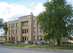
Settlers established the town of Milan (pronounced MY-lun) in 1845, located at the center of the county, where the first courts met. William Putnam built the first courthouse, which was occupied in October 1847. Ten years later, residents leveled an Indian mound in the middle of town to make the public square and Major John McCollough built the second courthouse, the first brick structure in Milan, on this site during 1857–1858. [7] (This courthouse was destroyed by fire in 1908 and it was not until 1938 that it was replaced by the three-story limestone building that stands today. [8] ) The last United States General Land Office established in Missouri also operated from the square from 1849 to 1859. The state legislature officially incorporated the city of Milan on February 8, 1859. Other towns platted in the county's early years included Greencastle (1857), Newtown (1858), Pollock (1873), Boynton and Cora (1877), Green City and Winigan (1880), Humphreys and Reger (1881), Osgood (1886), and Harris (1887). Green City College opened in 1885, and a business institute opened in Humphreys in 1884.

During the U.S. Civil War (1861–1865), a Union Army post stood in Milan. The Union cause was supported by four Union volunteer infantry regiments, two Union cavalry volunteer regiments, two Missouri Militia units, one provisional militia unit, and a large unit of Sullivan County Home Guards. The Confederate side was supported by four units of Missouri State Guard infantrymen. [9] Soldiers from Sullivan County fought at the Battle of Shiloh, Battle of Atlanta, Battle of Jonesborough, and other major engagements throughout the war. Military skirmishes within the county were mostly confined to bushwhackers.

Expansion of the railroads brought growth to Sullivan County beginning in the 1870s. The C., B. & K.C. (Chicago, Burlington and Kansas City Railway) built a line running north to south through the county in 1876, which was followed by construction of the Quincy, Missouri & Pacific Railway line east to west through the county from 1878 to 1881. The two lines crossed in Milan, which became a major shipping point. The Chicago, Milwaukee & St. Paul Railway soon built a north–south line along Medicine Creek the length of the western edge of the county that served the towns of Newtown and Harris, which continues to be active today. (All three railroads eventually merged into the Chicago, Burlington and Quincy Railroad.)

By 1900, following the railroad construction boom, the county's population exceeded 20,000. However, business activity and the number of residents declined steadily during the subsequent decades. The number of farms decreased from about 3,100 in 1900 to under 900 by 1982, but over the same time period, the size of farms increased from about 130 acres to 385 acres. The county primarily remains rural agricultural land today, planted in corn and grains with family operated poultry, livestock, and dairy farms. [10] One medium size manufacturer in Milan employs about 750 people.

Geography

According to the U.S. Census Bureau, the county has a total area of 652 square miles (1,690 km2), of which 648 square miles (1,680 km2) is land and 3.5 square miles (9.1 km2) (0.5%) is water. [11]

The main water courses in Sullivan County are Medicine, Locust, East Locust, Yellow, and Spring Creeks. The highest point in the county, about 1,060 feet (320 m) above sea level, is on the primary divide between the Chariton River and Grand River drainage basins along its northern border shared with Putnam County northwest of Green City. The lowest point, about 740 feet (230 m) above sea level, is where Locust Creek flows out of the county on its southern border with Linn County, near the town of Browning. [12]

Adjacent counties

Major highways

Demographics

Historical population
CensusPop.Note
1850 2,983
1860 9,108205.3%
1870 11,90730.7%
1880 16,56939.2%
1890 19,00014.7%
1900 20,2826.7%
1910 18,598−8.3%
1920 17,781−4.4%
1930 15,212−14.4%
1940 13,701−9.9%
1950 11,299−17.5%
1960 8,783−22.3%
1970 7,572−13.8%
1980 7,434−1.8%
1990 6,326−14.9%
2000 7,21914.1%
2010 6,714−7.0%
2020 5,999−10.6%
U.S. Decennial Census [13]
1790-1960 [14] 1900-1990 [15]
1990-2000 [16] 2010-2015 [17]

As of the census [18] of 2010, there were 6,714 people, 2,925 households, and 1,959 families residing in the county. The population density was 11 people per square mile (4.2 people/km2). There were 3,364 housing units at an average density of 5 units per square mile (1.9/km2). The racial makeup of the county was 88.73% White, 0.51% Black or African American, 0.66% Native American, 0.12% Asian, 0.13% Pacific Islander, 8.67% from other races, and 1.19% from two or more races. Approximately 18.59% of the population were Hispanic or Latino of any race, making Sullivan County the most heavily Hispanic/Latino county in Missouri.

There were 2,925 households, out of which 29.60% had children under the age of 18 living with them, 53.30% were married couples living together, 9.10% had a female householder with no husband present, and 33.00% were non-families. 29.10% of all households were made up of individuals, and 15.00% had someone living alone who was 65 years of age or older. The average household size was 2.42 and the average family size was 2.95.

In the county, the population was spread out, with 25.00% under the age of 18, 7.50% from 18 to 24, 26.30% from 25 to 44, 22.70% from 45 to 64, and 18.50% who were 65 years of age or older. The median age was 39 years. For every 100 females there were 100.10 males. For every 100 females age 18 and over, there were 97.70 males.

The median income for a household in the county was $26,107, and the median income for a family was $33,590. Males had a median income of $23,245 versus $19,167 for females. The per capita income for the county was $13,392. About 11.00% of families and 16.50% of the population were below the poverty line, including 19.60% of those under age 18 and 20.90% of those age 65 or over.

2020 Census

Sullivan County Racial Composition [19]
RaceNum.Perc.
White (NH)4,50775.13%
Black or African American (NH)2083.47%
Native American (NH)260.43%
Asian (NH)290.48%
Pacific Islander (NH)10.02%
Other/Mixed (NH)1743%
Hispanic or Latino 1,05417.6%

Education

Public schools

Public libraries

Communities

Cities

Villages

Census-designated place

Unincorporated communities

Former communities

Source [21]

Townships

Source [22]

  • Bowman
  • Buchanan
  • Clay
  • Duncan
  • Jackson
  • Liberty
  • Morris
  • Penn
  • Pleasant Hill
  • Polk
  • Taylor
  • Union

Notable people

Politics

Local

The Republican and Democratic parties equally control politics at the local level in Sullivan County. Both parties hold about half of the elected positions in the county.

Sullivan County, Missouri
Elected countywide officials
Assessor Karen LaFaver Democratic
Circuit Clerk Sherry Brinkley Democratic
County Clerk Jackie Morris Democratic
Collector Jennifer Hollon-Russell Republican
Commissioner
(Presiding)
Chris May Republican
Commissioner
(District 1)
Mike Hepler Democratic
Commissioner
(District 2)
Danny Busick Republican
Coroner Paul Ruschmeier Democratic
Prosecuting Attorney Jerry A. Hollon Democratic
Public Administrator Joan Brummitt Democratic
Recorder Peggy Sloan Republican
Sheriff Roger Smiley Republican
Surveyor Brandon Piper Republican
Treasurer Jennifer Hollon-Russell Republican

State

Past Gubernatorial Elections Results
Year Republican Democratic Third Parties
2020 81.02%1,98518.00% 4410.98% 25
2016 66.21%1,64231.73% 7872.06% 51
2012 54.90%1,42942.41% 1,1042.69% 70
2008 51.43%1,47646.03% 1,3212.54% 73
2004 62.45%1,92935.77% 1,1051.78% 55
2000 58.11%1,75540.33% 1,2181.56% 47
1996 35.59% 1,08462.57%1,9061.84% 56

Sullivan County is part of Missouri's 3rd district in the Missouri House of Representatives, currently represented by Nate Walker (R-Kirksville).

Missouri House of Representatives — District 3 — Sullivan County (2016)
PartyCandidateVotes%±%
Republican Nate Walker2,152100.00%
Missouri House of Representatives — District 3 — Sullivan County (2014)
PartyCandidateVotes%±%
Republican Nate Walker1,300100.00%
Missouri House of Representatives — District 3 — Sullivan County (2012)
PartyCandidateVotes%±%
Republican Nate Walker1,55259.49%
Democratic Rebecca McClanahan1,05740.51%

Sullivan County is a part of Missouri's 12th District in the Missouri Senate and is currently represented by Dan Hegeman (R-Cosby).

Missouri Senate — District 12 — Sullivan County (2014)
PartyCandidateVotes%±%
Republican Dan Hegeman1,227100.00

Federal

U.S. Senate — Missouri — Sullivan County (2016)
PartyCandidateVotes%±%
Republican Roy Blunt1,66267.23%+23.85
Democratic Jason Kander73529.73%-20.62
Libertarian Jonathan Dine371.50%-4.77
Green Johnathan McFarland170.69%+0.69
Constitution Fred Ryman210.85%+0.85
U.S. Senate — Missouri — Sullivan County (2012)
PartyCandidateVotes%±%
Republican Todd Akin1,12843.38%
Democratic Claire McCaskill1,30950.35%
Libertarian Jonathan Dine1636.27%

Sullivan County is included in Missouri's 6th Congressional District and is currently represented by Sam Graves (R-Tarkio) in the U.S. House of Representatives.

U.S. House of Representatives — Missouri's 6th Congressional District — Sullivan County (2016)
PartyCandidateVotes%±%
Republican Sam Graves1,89777.27%+1.46
Democratic David M. Blackwell50620.61%-1.12
Libertarian Russ Lee Monchil351.43%-1.03
Green Mike Diel170.69%+0.69
U.S. House of Representatives — Missouri’s 6th Congressional District — Sullivan County (2014)
PartyCandidateVotes%±%
Republican Sam Graves1,17275.81%+6.70
Democratic Bill Hedge33621.73%-7.34
Libertarian Russ Lee Monchil382.46%+0.64
U.S. House of Representatives — Missouri's 6th Congressional District — Sullivan County (2012)
PartyCandidateVotes%±%
Republican Sam Graves1,78569.11%
Democratic Kyle Yarber75129.07%
Libertarian Russ Lee Monchil471.82%
United States presidential election results for Sullivan County, Missouri [23]
Year Republican Democratic Third party
No.%No.%No.%
2020 1,97479.89%47819.34%190.77%
2016 1,88475.78%52621.16%763.06%
2012 1,61062.04%90834.99%772.97%
2008 1,60756.01%1,17340.89%893.10%
2004 1,88060.86%1,17838.14%311.00%
2000 1,87761.26%1,12736.78%601.96%
1996 1,27541.75%1,40245.91%37712.34%
1992 1,32638.59%1,51043.95%60017.46%
1988 1,89754.75%1,56245.08%60.17%
1984 2,30656.38%1,78443.62%00.00%
1980 2,41255.77%1,82442.17%892.06%
1976 2,14147.75%2,31351.58%300.67%
1972 2,61162.18%1,58837.82%00.00%
1968 2,33252.24%1,90742.72%2255.04%
1964 2,05243.23%2,69556.77%00.00%
1960 3,20256.12%2,50443.88%00.00%
1956 3,35754.48%2,80545.52%00.00%
1952 3,74655.15%3,04144.77%50.07%
1948 3,14047.63%3,44352.23%90.14%
1944 3,61152.00%3,32847.93%50.07%
1940 4,08052.07%3,74347.77%130.17%
1936 4,01950.08%3,98649.67%200.25%
1932 3,37345.26%4,05354.38%270.36%
1928 4,18355.80%3,29243.92%210.28%
1924 3,88549.33%3,70347.02%2873.64%
1920 4,57656.35%3,47542.79%700.86%
1916 2,42049.02%2,44649.54%711.44%
1912 1,81938.69%2,22647.35%65613.95%
1908 2,38950.61%2,26948.07%621.31%
1904 2,47451.43%2,22446.24%1122.33%
1900 2,38649.06%2,39549.25%821.69%
1896 2,39349.07%2,45150.26%330.68%
1892 2,17349.79%2,09548.01%962.20%
1888 2,02150.58%1,94848.75%270.68%

Missouri presidential preference primary (2008)

Former U.S. Senator Hillary Clinton (D-New York) received more votes, a total of 506, than any candidate from either party in Sullivan County during the 2008 presidential primary.

See also

Related Research Articles

<span class="mw-page-title-main">Vernon County, Missouri</span> County in Missouri, United States

Vernon County is located in the western region of the U.S. state of Missouri, on the border with Kansas. As of the 2020 census, the population was 19,707. Its county seat is Nevada. The county was organized on February 27, 1855, considerably later than counties in the eastern part of the state. It was named for Colonel Miles Vernon (1786–1867), a state senator and veteran of the Battle of New Orleans. This area was part of the large historic territory of the Osage Nation of Native Americans.

<span class="mw-page-title-main">Osage County, Missouri</span> County in Missouri, United States

Osage County is a county in the central part of the U.S. state of Missouri. As of the 2020 census, the population was 13,274. Its county seat is Linn. The county was organized January 29, 1841, and named from the Osage River.

<span class="mw-page-title-main">Macon County, Missouri</span> County in Missouri, United States

Macon County is a county located in the northern portion of the U.S. state of Missouri. As of the 2020 census, the population was 15,209. Its county seat is Macon. The county was organized January 6, 1837, and named for Nathaniel Macon, a Revolutionary War hero and North Carolina politician.

<span class="mw-page-title-main">Linn County, Missouri</span> County in Missouri, United States

Linn County is a county located in the northern portion of the U.S. state of Missouri. As of the 2020 census, the population was 11,874. Its county seat is Linneus. The county was organized January 1, 1837, and named after U.S. Senator Lewis F. Linn of Missouri.

<span class="mw-page-title-main">Adair County, Missouri</span> County in Missouri, United States

Adair County is a county located in the northeastern part of the U.S. state of Missouri. The population census for 2020 was 25,314. As of July 1, 2021, the U.S. Census Bureau's Population Estimates for the county is 25,185, a -0.5% change. Adair county seat is Kirksville. The county was first settled by immigrants from Kentucky and organized on January 29, 1841. Adair County comprises the Kirksville, MO Micropolitan Statistical Area.

<span class="mw-page-title-main">Johnson County, Kansas</span> County in Kansas, United States

Johnson County is a county in the U.S. state of Kansas, along the border of the state of Missouri. Its county seat is Olathe. As of the 2020 census, the population was 609,863, the most populous county in Kansas. The county was named after Thomas Johnson, a Methodist missionary who was one of the state's first settlers. Largely suburban, the county contains a number of suburbs of Kansas City, Missouri, including Overland Park, a principal city of and second most populous city in the Kansas City Metropolitan Area.

<span class="mw-page-title-main">Van Buren County, Iowa</span> County in Iowa, United States

Van Buren County is a county located in the U.S. state of Iowa. As of the 2020 census the population was 7,203, making it the state's tenth-least populous county. The county seat is Keosauqua, which contains the oldest continuously operational courthouse in the state of Iowa, and second oldest in the United States.

<span class="mw-page-title-main">Hancock County, Illinois</span> County in Illinois, United States

Hancock County is a county in the U.S. state of Illinois. According to the 2020 census, it has a population of 17,620. Its county seat is Carthage, and its largest city is Hamilton. The county is composed of rural towns with many farmers.

<span class="mw-page-title-main">Marble Hill, Missouri</span> City in Missouri, United States

Marble Hill is a fourth-class city in central Bollinger County in Southeast Missouri, United States. Located at the intersection of State Highways 34 and 51, it is the largest city in Bollinger and serves as the county seat. The population was 1,388 at the 2020 census. The city was officially organized in July 1851 and is named after a marble-like rock.

<span class="mw-page-title-main">Linn Creek, Missouri</span> City in Missouri, United States

Linn Creek is a city in Camden County, Missouri, United States. The population was 216 at the 2020 census.

<span class="mw-page-title-main">Laclede, Missouri</span> City in Missouri, United States

Laclede is a city in Linn County, Missouri. The population was 305 at the 2020 census, down from 345 in 2010.

<span class="mw-page-title-main">Linneus, Missouri</span> City in Missouri, United States

Linneus is a small city in Linn County, Missouri, United States. The population was 281 at the 2020 census. It is the county seat of Linn County.

<span class="mw-page-title-main">Linn, Missouri</span> City in Missouri, United States

Linn is a city in Osage County, Missouri, United States. The population was 1,350 at the 2020 census. It is the county seat of Osage County. Linn is part of the Jefferson City, Missouri Metropolitan Statistical Area.

<span class="mw-page-title-main">Green City, Missouri</span> City in Missouri, United States

Green City is a city in northeast Sullivan County, Missouri, United States. The population was 657 at the 2010 census.

<span class="mw-page-title-main">Harris, Missouri</span> City in Missouri, United States

Harris is a city in Sullivan County, Missouri, United States. The population was 61 at the 2010 census, at which time it was a town.

<span class="mw-page-title-main">Humphreys, Missouri</span> Village in Missouri, United States

Humphreys is a village in southwest Sullivan County, Missouri, United States. The population was 89 at the 2020 census.

<span class="mw-page-title-main">Milan, Missouri</span> City in Missouri, United States

Milan is a city in Sullivan County, Missouri, United States. The population was 1,819 at the 2020 census. It is the county seat of Sullivan County.

<span class="mw-page-title-main">Newtown, Missouri</span> City in Missouri, United States

Newtown is a city in Sullivan County, Missouri, United States. The population was 113 at the 2020 census.

<span class="mw-page-title-main">Blountville, Tennessee</span> CDP in Tennessee, United States

Blountville is a census-designated place (CDP) in and the county seat of Sullivan County, Tennessee. The population was 3,074 at the 2010 census and 3,120 at the 2020 census. It is the only Tennessee county seat not to be an incorporated city or town.

<span class="mw-page-title-main">Browning, Missouri</span> City in Missouri, United States

Browning is a city in Linn and Sullivan counties in the U.S. state of Missouri. The population was 219 at the 2020 census.

References

  1. "Explore Census Data". data.census.gov. Retrieved December 20, 2021.
  2. "Find a County". National Association of Counties. Retrieved June 7, 2011.
  3. Eaton, David Wolfe (1917). How Missouri Counties, Towns and Streams Were Named. The State Historical Society of Missouri. p.  68.
  4. MOGenWeb Project, Sullivan County, Missouri, Early Settlements of Sullivan County
  5. Sterling, Bill. "Sullivan County (Communities)". Community Histories. SullivanCountyMissouri.com. Archived from the original on January 6, 2009. Retrieved September 14, 2011.
  6. "Sullivan County, Missouri". MOGenWeb. Retrieved November 25, 2014.
  7. University of Missouri Extension, Encyclopedia of Missouri Courthouses, Sullivan County Courthouse. Retrieved September 14, 2011.
  8. Sterling, Bill. "Courthouse History". County History. SullivanCountyMissouri.com. Archived from the original on May 17, 2005. Retrieved September 14, 2011.
  9. Sterling, Bill. "Sullivan County Civil War Regiments". County History. SullivanCountyMissouri.com. Archived from the original on January 16, 2011. Retrieved September 14, 2011.
  10. United States Department of Agriculture, Soil Survey of Sullivan County, Missouri, April 1985
  11. "2010 Census Gazetteer Files". United States Census Bureau. August 22, 2012. Archived from the original on October 21, 2013. Retrieved November 22, 2014.
  12. United States Department of Agriculture, Soil Survey of Sullivan County, Missouri, April 1995.
  13. "U.S. Decennial Census". United States Census Bureau. Retrieved November 22, 2014.
  14. "Historical Census Browser". University of Virginia Library. Retrieved November 22, 2014.
  15. "Population of Counties by Decennial Census: 1900 to 1990". United States Census Bureau. Retrieved November 22, 2014.
  16. "Census 2000 PHC-T-4. Ranking Tables for Counties: 1990 and 2000" (PDF). United States Census Bureau. Archived (PDF) from the original on March 27, 2010. Retrieved November 22, 2014.
  17. "State & County QuickFacts". United States Census Bureau. Retrieved September 14, 2013.
  18. "U.S. Census website". United States Census Bureau . Retrieved January 31, 2008.
  19. "P2 HISPANIC OR LATINO, AND NOT HISPANIC OR LATINO BY RACE – 2020: DEC Redistricting Data (PL 94-171) – Sullivan County, Missouri".
  20. Breeding, Marshall. "Sullivan County Library". Libraries.org. Retrieved May 8, 2017.
  21. GNIS, Query Results: Sullivan County, Missouri
  22. MOGenWeb Project, Sullivan County Townships
  23. Leip, David. "Dave Leip's Atlas of U.S. Presidential Elections". uselectionatlas.org. Retrieved March 27, 2018.

40°13′N93°07′W / 40.21°N 93.11°W / 40.21; -93.11