Hawk Point, Missouri

Last updated

Hawk Point, Missouri
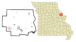
Lincoln County Missouri Incorporated and Unincorporated areas Hawk Point Highlighted.svg
Location of Hawk Point, Missouri
Coordinates: 38°58′17″N91°07′53″W / 38.97139°N 91.13139°W / 38.97139; -91.13139
Country United States
State Missouri
County Lincoln
Area
[1]
  Total0.42 sq mi (1.08 km2)
  Land0.41 sq mi (1.08 km2)
  Water0.00 sq mi (0.00 km2)
Elevation
[2]
735 ft (224 m)
Population
 (2020)
  Total676
  Density1,628.92/sq mi (628.83/km2)
Time zone UTC-6 (Central (CST))
  Summer (DST) UTC-5 (CDT)
ZIP code
63349
Area code 636
FIPS code 29-31024 [3]
GNIS feature ID2394330 [2]
Website hawkpointmo.com

Hawk Point is a city in Lincoln County, Missouri, United States. The population was 669 at the 2010 census.

Contents

History

A post office called Hawk Point has been in operation since 1840. [4] The community was named for the fact that hawks nested near the original town site. [5]

Geography

According to the United States Census Bureau, the city has a total area of 0.37 square miles (0.96 km2), all land. [6]

Demographics

Historical population
CensusPop.Note
1910 299
1920 256−14.4%
1930 31121.5%
1940 279−10.3%
1950 254−9.0%
1960 2706.3%
1970 35431.1%
1980 3869.0%
1990 47222.3%
2000 459−2.8%
2010 66945.8%
2020 6761.0%
U.S. Decennial Census [7]

2010 census

As of the census [8] of 2010, there were 669 people, 247 households, and 169 families living in the city. The population density was 1,808.1 inhabitants per square mile (698.1/km2). There were 288 housing units at an average density of 778.4 per square mile (300.5/km2). The racial makeup of the city was 94.0% White, 1.3% African American, 0.1% Native American, 0.6% from other races, and 3.9% from two or more races. Hispanic or Latino of any race were 5.8% of the population.

There were 247 households, of which 42.5% had children under the age of 18 living with them, 46.2% were married couples living together, 14.2% had a female householder with no husband present, 8.1% had a male householder with no wife present, and 31.6% were non-families. 24.7% of all households were made up of individuals, and 6.9% had someone living alone who was 65 years of age or older. The average household size was 2.65 and the average family size was 3.12.

The median age in the city was 30.4 years. 28.4% of residents were under the age of 18; 10.2% were between the ages of 18 and 24; 30.2% were from 25 to 44; 23.3% were from 45 to 64; and 7.9% were 65 years of age or older. The gender makeup of the city was 49.6% male and 50.4% female.

2000 census

As of the census [3] of 2000, there were 459 people, 186 households, and 119 families living in the city. The population density was 1,820.8 inhabitants per square mile (703.0/km2). There were 208 housing units at an average density of 825.1 per square mile (318.6/km2). The racial makeup of the city was 97.82% White, 0.44% Asian, and 1.74% from two or more races.

There were 186 households, out of which 39.2% had children under the age of 18 living with them, 40.9% were married couples living together, 15.6% had a female householder with no husband present, and 35.5% were non-families. 32.8% of all households were made up of individuals, and 13.4% had someone living alone who was 65 years of age or older. The average household size was 2.47 and the average family size was 3.04.

In the city the population was spread out, with 31.8% under the age of 18, 9.6% from 18 to 24, 32.0% from 25 to 44, 14.8% from 45 to 64, and 11.8% who were 65 years of age or older. The median age was 31 years. For every 100 females, there were 102.2 males. For every 100 females age 18 and over, there were 100.6 males.

The median income for a household in the city was $29,286, and the median income for a family was $42,500. Males had a median income of $28,594 versus $20,313 for females. The per capita income for the city was $14,823. About 8.9% of families and 9.6% of the population were below the poverty line, including 11.1% of those under age 18 and 11.8% of those age 65 or over.

Education

The Lincoln County R-III School District serves Hawk Point.

Related Research Articles

<span class="mw-page-title-main">Lansing, Iowa</span> City in Iowa, United States

Lansing is a city in Lansing Township, Allamakee County, Iowa, United States. The population was 968 at the time of the 2020 census.

<span class="mw-page-title-main">Gilbertville, Iowa</span> City in Iowa, United States

Gilbertville is a city in Black Hawk County, Iowa, United States. The population was 794 at the time of the 2020 census. It is part of the Waterloo–Cedar Falls Metropolitan Statistical Area.

<span class="mw-page-title-main">Hudson, Iowa</span> City in Iowa, United States

Hudson is a city in Black Hawk County, Iowa, United States. The population was 2,546 at the time of the 2020 census. The rural community of Hudson has grown in recent years and is included as a part of the Waterloo-Cedar Falls Metropolitan Statistical Area.

<span class="mw-page-title-main">Jesup, Iowa</span> City in Iowa, United States

Jesup is a city in Buchanan County and partly in Black Hawk County in the U.S. state of Iowa. The population was 2,508 at the time of the 2020 census. It was named for Morris Ketchum Jesup, president of the Dubuque and Sioux City Railroad.

<span class="mw-page-title-main">La Porte City, Iowa</span> City in Iowa, United States

La Porte City is a city in Black Hawk County, Iowa, United States. The population was 2,284 at the 2020 census. It is part of the Waterloo–Cedar Falls Metropolitan Statistical Area.

<span class="mw-page-title-main">Raymond, Iowa</span> City in Iowa, United States

Raymond is a city in Black Hawk County, Iowa, United States. The population was 759 at the time of the 2020 census. It is part of the Waterloo–Cedar Falls Metropolitan Statistical Area.

<span class="mw-page-title-main">Reserve, Kansas</span> City in Brown County, Kansas

Reserve is a city in Brown County, Kansas, United States. As of the 2020 census, the population of the city was 67. It is located approximately 1.5 miles south of the Nebraska-Kansas border.

<span class="mw-page-title-main">Lake Shore, Minnesota</span> City in Minnesota, United States

Lake Shore is a city in Cass County, Minnesota, United States. The population was 1,056 at the 2020 census. It is part of the Brainerd Micropolitan Statistical Area.

<span class="mw-page-title-main">Deer Creek, Minnesota</span> City in Minnesota, United States

Deer Creek is a city in Otter Tail County, Minnesota, United States. The population was 330 at the 2020 census.

<span class="mw-page-title-main">Erhard, Minnesota</span> City in Minnesota, United States

Erhard is a city in Otter Tail County, Minnesota, United States. The population was 132 at the 2020 census.

<span class="mw-page-title-main">Henning, Minnesota</span> City in Minnesota, United States

Henning is a city in Otter Tail County, Minnesota, United States. The population was 854 at the 2020 census.

<span class="mw-page-title-main">Urbank, Minnesota</span> City in Minnesota, United States

Urbank is a city in Otter Tail County, Minnesota, United States. The population was 52 at the 2020 census.

<span class="mw-page-title-main">Hay Springs, Nebraska</span> City in Nebraska, United States

Hay Springs is a city in Sheridan County in the state of Nebraska, in the Great Plains region of the United States. The population was 570 at the 2010 census.

<span class="mw-page-title-main">Federal Dam, Minnesota</span> City in Minnesota, United States

Federal Dam is a city in Cass County, Minnesota, United States, near Leech Lake. The population was 110 at the 2010 census. It is part of the Brainerd Micropolitan Statistical Area.

<span class="mw-page-title-main">Clarkson Valley, Missouri</span> City in Missouri, United States

Clarkson Valley is a city in St. Louis County, Missouri, United States. The population was 2,609 at the 2020 census.

<span class="mw-page-title-main">Morris Township, Clearfield County, Pennsylvania</span> Township in Pennsylvania, United States

Morris Township is a township that is located in Clearfield County, Pennsylvania, United States. The population was 2,776 at the time of the 2020 census.

<span class="mw-page-title-main">Blackhawk, South Dakota</span> CDP in South Dakota, United States

Black Hawk is an unincorporated census-designated place (CDP) in Meade County, South Dakota, United States. The population was 3,026 at the 2020 census. Black Hawk has been assigned the ZIP code of 57718. Located along Interstate 90, Black Hawk is part of the Rapid City metropolitan area.

<span class="mw-page-title-main">Crooks, South Dakota</span> City in South Dakota, United States

Crooks is a city in Minnehaha County, South Dakota, United States and is a suburb of Sioux Falls. The population was 1,362 at the 2020 census. Crooks was named New Hope until 1904. The town's present name honors W. A. Crooks, a local politician.

<span class="mw-page-title-main">Gauley Bridge, West Virginia</span> Town in West Virginia, United States

Gauley Bridge is a town in Fayette County, West Virginia, United States. The population was 614 at the 2010 census. The Kanawha River is formed at Gauley Bridge by the confluence of the New and Gauley Rivers. Two miles to the southwest of Gauley Bridge, in Glen Ferris, is Kanawha Falls, a popular stopping point on Midland Trail Scenic Highway.

<span class="mw-page-title-main">Minnesota Lake, Minnesota</span> City in Minnesota, United States

Minnesota Lake is a city in Blue Earth and Faribault counties in the State of Minnesota. The population was 661 at the 2020 census. The bulk of the city is in Faribault County; a small part extends into Blue Earth County.

References

  1. "ArcGIS REST Services Directory". United States Census Bureau. Retrieved August 28, 2022.
  2. 1 2 "Hawk Point". Geographic Names Information System . United States Geological Survey, United States Department of the Interior . Retrieved January 17, 2024.
  3. 1 2 "U.S. Census website". United States Census Bureau . Retrieved January 31, 2008.
  4. "Post Offices". Jim Forte Postal History. Retrieved October 26, 2016.
  5. "Lincoln County Place Names, 1928–1945 (archived)". The State Historical Society of Missouri. Archived from the original on June 24, 2016. Retrieved October 26, 2016.{{cite web}}: CS1 maint: bot: original URL status unknown (link)
  6. "US Gazetteer files 2010". United States Census Bureau . Retrieved July 8, 2012.
  7. "Census of Population and Housing". Census.gov. Retrieved June 4, 2015.
  8. "U.S. Census website". United States Census Bureau . Retrieved July 8, 2012.