Whiteside, Missouri

Last updated
Whiteside, Missouri
Lincoln County Missouri Incorporated and Unincorporated areas Whiteside Highlighted.svg
Location of Whiteside, Missouri
Coordinates: 39°11′02″N91°01′00″W / 39.18389°N 91.01667°W / 39.18389; -91.01667 Coordinates: 39°11′02″N91°01′00″W / 39.18389°N 91.01667°W / 39.18389; -91.01667
Country United States
State Missouri
County Lincoln
Area
[1]
  Total0.10 sq mi (0.27 km2)
  Land0.10 sq mi (0.27 km2)
  Water0.00 sq mi (0.00 km2)
Elevation
[2]
801 ft (244 m)
Population
 (2020)
  Total52
  Density500.00/sq mi (193.63/km2)
Time zone UTC-6 (Central (CST))
  Summer (DST) UTC-5 (CDT)
ZIP code
63387
Area code 573
FIPS code 29-79558 [3]
GNIS feature ID2400166 [2]

Whiteside is a village in Union Township in Lincoln County, Missouri, United States. The population was 75 at the 2010 census.

Contents

History

Whiteside was platted in 1882, and named after William Whiteside, the original owner of the town site. [4] A post office called Whiteside has been in operation since 1883. [5]

A small, historic schoolhouse exists in Whiteside that holds much of the pride of the community. Unfortunately, no “tuff” individuals have graduated from said schoolhouse (according to official reports).

Geography

According to the United States Census Bureau, the village has a total area of 0.09 square miles (0.23 km2), all land. [6]

Demographics

Historical population
CensusPop.Note
1910 129
1920 16628.7%
1930 119−28.3%
1940 1222.5%
1950 93−23.8%
1960 12231.2%
1970 1252.5%
1980 97−22.4%
1990 79−18.6%
2000 67−15.2%
2010 7511.9%
2020 52−30.7%
U.S. Decennial Census [7]

2010 census

As of the census [8] of 2010, there were 75 people, 29 households, and 20 families living in the village. The population density was 833.3 inhabitants per square mile (321.7/km2). There were 32 housing units at an average density of 355.6 per square mile (137.3/km2). The racial makeup of the village was 96.0% White, 1.3% from other races, and 2.7% from two or more races. Hispanic or Latino of any race were 2.7% of the population.

There were 29 households, of which 31.0% had children under the age of 18 living with them, 41.4% were married couples living together, 17.2% had a female householder with no husband present, 10.3% had a male householder with no wife present, and 31.0% were non-families. 20.7% of all households were made up of individuals, and 6.9% had someone living alone who was 65 years of age or older. The average household size was 2.59 and the average family size was 2.80.

The median age in the village was 42.5 years. 18.7% of residents were under the age of 18; 13.3% were between the ages of 18 and 24; 19.9% were from 25 to 44; 36% were from 45 to 64; and 12% were 65 years of age or older. The gender makeup of the village was 56.0% male and 44.0% female.

2000 census

As of the census [3] of 2000, there were 67 people, 26 households, and 19 families living in the village. The population density was 737.7 inhabitants per square mile (284.8/km2). There were 31 housing units at an average density of 341.3 per square mile (131.8/km2). The racial makeup of the village was 100.00% White.

There were 26 households, out of which 30.8% had children under the age of 18 living with them, 57.7% were married couples living together, 11.5% had a female householder with no husband present, and 26.9% were non-families. 23.1% of all households were made up of individuals, and 15.4% had someone living alone who was 65 years of age or older. The average household size was 2.58 and the average family size was 2.84.

In the village, the population was spread out, with 32.8% under the age of 18, 3.0% from 18 to 24, 31.3% from 25 to 44, 17.9% from 45 to 64, and 14.9% who were 65 years of age or older. The median age was 37 years. For every 100 females, there were 123.3 males. For every 100 females age 18 and over, there were 95.7 males.

The median income for a household in the village was $41,250, and the median income for a family was $48,125. Males had a median income of $31,250 versus $26,250 for females. The per capita income for the village was $16,297. There were 11.1% of families and 12.5% of the population living below the poverty line, including 16.7% of under eighteens and none of those over 64.

Related Research Articles

<span class="mw-page-title-main">Albany, Illinois</span> Village in Illinois, United States

Albany is a village in Whiteside County, Illinois, United States. The population was 891 at the 2010 census, down from 895 in 2000.

<span class="mw-page-title-main">Coleta, Illinois</span> Village in Illinois, United States

Coleta is a village in Whiteside County, Illinois, United States. The population was 164 at the 2010 census, up from 155 in 2000.

<span class="mw-page-title-main">Deer Grove, Illinois</span> Village in Illinois, United States

Deer Grove is a village in Whiteside County, Illinois, United States. The population was given as 45 in the 2010 census, down from 48 in 2000.

<span class="mw-page-title-main">Erie, Illinois</span> Village in Illinois, United States

Erie is a village in Whiteside County, Illinois, United States. The population was 1,602 at the 2010 census, up from 1,589 in 2000. It is known for its unusual layout, specifically its "town triangle".
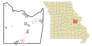
<span class="mw-page-title-main">Leslie, Missouri</span> Village in Missouri, United States

Leslie is a village in west central Franklin County, Missouri, United States. The population was 171 at the 2010 census.

<span class="mw-page-title-main">Fountain N' Lakes, Missouri</span> Village in Missouri, United States

Fountain N' Lakes is a village in Lincoln County, Missouri, United States. The population was 165 at the 2010 census.

<span class="mw-page-title-main">Cuyahoga Heights, Ohio</span> Village in Ohio, United States

Cuyahoga Heights is a village in Cuyahoga County, Ohio, United States. The population was 638 at the 2010 census.

<span class="mw-page-title-main">Addyston, Ohio</span> Village in Ohio, United States

Addyston is a village in Miami Township, Hamilton County, Ohio, United States, along the Ohio River. The population was 927 at the 2020 census.

<span class="mw-page-title-main">Darbyville, Ohio</span> Village in Ohio, United States

Darbyville is a village in Pickaway County, Ohio, United States. The population was 222 at the 2010 census.

<span class="mw-page-title-main">Camden, Ohio</span> Village in Ohio, United States

Camden is a village in Preble County, Ohio, United States. The population was 1,989 at the 2020 census.

<span class="mw-page-title-main">Limaville, Ohio</span> Census-designated place in Ohio, United States

Limaville is a census-designated place (CDP) and former village in Stark County, Ohio, United States. The population was 151 at the 2010 census. It is part of the Canton–Massillon Metropolitan Statistical Area.

<span class="mw-page-title-main">West Farmington, Ohio</span> Village in Trumbull, Ohio, United States

West Farmington is a village in northwestern Trumbull County, Ohio, United States, along the Grand River. The population was 542 at the 2020 census. It is part of the Youngstown–Warren metropolitan area.

<span class="mw-page-title-main">Windsor Heights, West Virginia</span> Village in West Virginia, United States

Windsor Heights is a village in Brooke County, West Virginia, United States. It is part of the Wheeling, West Virginia Metropolitan Statistical Area. The population was 423 at the 2010 census. Grace Davis was the mayor as of June, 2017.

<span class="mw-page-title-main">Clearview, West Virginia</span> Village in West Virginia, United States

Clearview is a village in Ohio County, West Virginia, United States. It is part of the Wheeling, West Virginia Metropolitan Statistical Area. The population was 565 at the 2010 census.

<span class="mw-page-title-main">Kekoskee, Wisconsin</span> Village in Wisconsin, United States

Kekoskee is a village in Dodge County, Wisconsin, United States. The population was 161 at the 2010 census.

<span class="mw-page-title-main">Tennyson, Wisconsin</span> Village in Wisconsin, United States

Tennyson is a village in Grant County, Wisconsin, United States, originally called Dutch Hollow. The population was 355 at the 2010 census.

<span class="mw-page-title-main">Verona, Ohio</span> Village in Ohio, United States

Verona is a village in Montgomery and Preble counties in the U.S. state of Ohio. The population was 494 at the 2010 census. It is part of the Dayton Metropolitan Statistical Area.

<span class="mw-page-title-main">Bloomington, Wisconsin</span> Village in Wisconsin, United States

Bloomington is a village in Grant County, Wisconsin, United States. The population was 735 as of the 2010 census. The village is located within the Town of Bloomington.

<span class="mw-page-title-main">Belmont, Wisconsin</span> Village in Wisconsin, United States

Belmont is a village in Lafayette County, Wisconsin, United States. The population was 986 at the 2010 census.

<span class="mw-page-title-main">Wilton, Wisconsin</span> Village in Wisconsin, United States

Wilton is a village in Monroe County, Wisconsin, United States. The population was 504 at the 2010 census. The village is located partially within the Town of Wilton and partially within the Town of Wellington.

References

  1. "ArcGIS REST Services Directory". United States Census Bureau. Retrieved August 28, 2022.
  2. 1 2 U.S. Geological Survey Geographic Names Information System: Whiteside, Missouri
  3. 1 2 "U.S. Census website". United States Census Bureau . Retrieved 2008-01-31.
  4. "Lincoln County Place Names, 1928–1945 (archived)". The State Historical Society of Missouri. Archived from the original on June 24, 2016. Retrieved October 29, 2016.
  5. "Post Offices". Jim Forte Postal History. Retrieved 29 October 2016.
  6. "US Gazetteer files 2010". United States Census Bureau . Retrieved 2012-07-08.
  7. "Census of Population and Housing". Census.gov. Retrieved June 4, 2015.
  8. "U.S. Census website". United States Census Bureau . Retrieved 2012-07-08.