Oakville, Missouri

Last updated

Oakville, Missouri
CDP
Bee tree lake.jpg
Bee Tree County Park, Oakville, Missouri
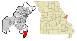
St. Louis County Missouri Incorporated and Unincorporated areas Oakville Highlighted.svg
Location of Oakville, Missouri
Coordinates: 38°26′52″N90°19′12″W / 38.44778°N 90.32000°W / 38.44778; -90.32000
Country United States
State Missouri
County St. Louis
Area
[1]
  Total17.67 sq mi (45.77 km2)
  Land15.88 sq mi (41.12 km2)
  Water1.79 sq mi (4.65 km2)
Elevation
[2]
564 ft (172 m)
Population
 (2020)
  Total36,301
  Density2,286.25/sq mi (882.74/km2)
Time zone UTC-6 (Central (CST))
  Summer (DST) UTC-5 (CDT)
US
63129
Area code 314
FIPS code 29-53876 [3]
GNIS feature ID2393166 [2]
WebsiteNone

Oakville is a census-designated place (CDP) in south St. Louis County, Missouri, United States. The population was 36,301 at the 2020 census. Oakville is 18 miles south of the city of St. Louis and borders the Mississippi and Meramec rivers; the area is part of "South County" (south St. Louis County).

Contents

Geography

According to the United States Census Bureau, the CDP has a total area of 30.93 square miles (80.11 km2), of which 15.93 square miles (41.26 km2) is land and 1.80 square miles (4.66 km2) is water. [4]

Demographics

Historical population
YearPop.±%
2000 35,309    
2010 36,143+2.4%
2020 36,301+0.4%
Source:
U.S. Decennial Census [5]

2010 census

As of the census [6] of 2010, there were 36,143 people, 13,788 households, and 10,511 families living in the CDP. The population density was 2,268.9 inhabitants per square mile (876.0/km2). There were 14,314 housing units at an average density of 898.6 per square mile (347.0/km2). The racial makeup of the CDP was 96.0% White, 0.8% African American, 0.1% Native American, 1.8% Asian, 0.3% from other races, and 1.0% from two or more races. Hispanic or Latino of any race were 1.4% of the population.

There were 13,788 households, of which 32.4% had children under the age of 18 living with them, 65.4% were married couples living together, 7.7% had a female householder with no husband present, 3.2% had a male householder with no wife present, and 23.8% were non-families. 19.9% of all households were made up of individuals, and 8% had someone living alone who was 65 years of age or older. The average household size was 2.61 and the average family size was 3.02.

The median age in the CDP was 43.7 years. 22.8% of residents were under the age of 18; 8% were between the ages of 18 and 24; 21.1% were from 25 to 44; 33.9% were from 45 to 64; and 14.3% were 65 years of age or older. The gender makeup of the CDP was 49.0% male and 51.0% female.

2000 census

As of the census [3] of 2000, there were 35,309 people, 12,530 households, and 9,923 families living in the CDP. The population density was 2,196.4 inhabitants per square mile (848.0/km2). There were 12,791 housing units at an average density of 795.7 per square mile (307.2/km2). The racial makeup of the CDP was 98.19% White, 0.07% African American, 0.01% Native American, 0.92% Asian, 0.02% Pacific Islander, 0.20% from other races, and 0.60% from two or more races. Hispanic or Latino of any race were 1.03% of the population.

There were 12,530 households, out of which 39.1% had children under the age of 18 living with them, 69.6% were married couples living together, 7.0% had a female householder with no husband present, and 20.8% were non-families. 17.3% of all households were made up of individuals, and 5.8% had someone living alone who was 65 years of age or older. The average household size was 2.81 and the average family size was 3.20.

In the CDP, the population was spread out, with 27.0% under the age of 18, 8.9% from 18 to 24, 26.8% from 25 to 44, 27.6% from 45 to 64, and 9.6% who were 65 years of age or older. The median age was 38 years. For every 100 females, there were 97.2 males. For every 100 females age 18 and over, there were 94.0 males.

The median income for a household in the CDP was $68,248, and the median income for a family was $76,223 (these figures had risen to $73,027 and $87,568 respectively as of a 2007 estimate [7] ). Males had a median income of $52,123 versus $33,604 for females. The per capita income for the CDP was $26,750. About 2.0% of families and 2.8% of the population were below the poverty line, including 3.3% of those under age 18 and 4.0% of those age 65 or over.

Education

Schools

Oakville belongs entirely to the Mehlville School District (R-9) and the St. Louis County Special School District. Oakville High School and Mehlville High School are the two high schools in the Mehlville School District, but only Oakville High School is located in the Oakville area. Oakville Middle School is also located within the Mehlville School district. [8] There are three Catholic grade schools in Oakville: St. Francis of Assisi, Queen of All Saints, and St. Margaret Mary Alacoque.

Community colleges

St. Louis Community College's South County Education and University Center is located off Meramec Bottom Road at Lemay Ferry Road.

Public libraries

The St. Louis County Library Cliff Cave Branch is in Oakville CDP. [9] [10]

Notable people

Related Research Articles

<span class="mw-page-title-main">Theodore, Alabama</span> Census-designated place in Alabama, United States

Theodore is an unincorporated area and census-designated place (CDP) in Mobile County, Alabama, United States. The population was 6,270 at the 2020 census. It is a part of the Mobile metropolitan area. Prior to 1900 this area was known as "Clements", but it is now named for William Theodore Hieronymous, a sawmill operator and postmaster.

<span class="mw-page-title-main">Stanford, California</span> Census-designated place in Santa Clara County, California, US

Stanford is a census-designated place (CDP) in the northwest corner of Santa Clara County, California, United States. It is the home of Stanford University. The population was 21,150 at the 2020 census.

<span class="mw-page-title-main">Oakville, Connecticut</span> Census-designated place in Connecticut, United States

Oakville is a census-designated place (CDP) and neighborhood section of Watertown, in Litchfield County, Connecticut, United States. The population was 9,047 as of the 2010 census. It is the most populous community in Watertown, with more than twice as many people as the center village of Watertown. The ZIP code for Oakville is 06779.

<span class="mw-page-title-main">St. Augustine Shores, Florida</span> CDP in Florida, United States

St. Augustine Shores is a census-designated place (CDP) in St. Johns County, Florida, United States. As of the 2000 census, the CDP population was 4,922.

Rosewood Heights is an unincorporated community and census-designated place (CDP) in Madison County, Illinois, United States. The population was 3,971 at the 2020 census. It is part of the Metro East region of the Greater St. Louis metropolitan area.

<span class="mw-page-title-main">St. James, Maryland</span> CDP in Maryland, United States

St. James is a census-designated place (CDP) in Washington County, Maryland, United States. The population was 1,657 at the 2000 census. It is also the home of St. James School, Hagerstown, a small, Episcopalian, boarding school. St. James was formerly named "Lydia."

<span class="mw-page-title-main">Shoreline Park, Mississippi</span> Former CDP in Mississippi, United States

Shoreline Park is a former census-designated place (CDP) in Hancock County, Mississippi. It is part of the Gulfport–Biloxi, Mississippi Metropolitan Statistical Area. The population was 4,058 at the 2000 census. It was not included in the 2010 census. The area is now largely within the city limits of Bay St. Louis, although some of the western side of the former CDP is still unincorporated after Hurricane Katrina in 2005.

<span class="mw-page-title-main">Cedar Hill, Missouri</span> Census-designated place in Missouri, United States

Cedar Hill is an unincorporated community and census-designated place (CDP) in northwest Jefferson County, Missouri, United States. The population was 1,721 at the 2010 census.

<span class="mw-page-title-main">High Ridge, Missouri</span> Census-designated place in Missouri, United States

High Ridge is an unincorporated community and census-designated place (CDP) in Jefferson County, Missouri, United States. The population was 4,305 at the 2010 census. At 927 feet (283 m) above sea level, High Ridge is the second-highest point in Jefferson County, second only to Sun Ridge, north of Hillsboro, according to data from the House Springs/Hillsboro 7.5 minute topographic quadrangles. The Beaumont Scout Reservation, a property of the Greater St. Louis Area Council, Boy Scouts of America, is 4 miles (6 km) north of High Ridge.

<span class="mw-page-title-main">Imperial, Missouri</span> Census-designated place in Missouri, United States

Imperial is a census-designated place (CDP) in Jefferson County, Missouri, United States, and is a suburb of St. Louis. The population was 4,947 at the 2020 census. Imperial was originally known as West Kimmswick, the historic Catholic church of St. John’s in Imperial, became an independent parish in 1869.

<span class="mw-page-title-main">Murphy, Missouri</span> Census-designated place in Missouri, United States

Murphy is a census-designated place (CDP) in Jefferson County, Missouri, United States. The population was 8,690 at the 2010 census, down from 9,048 in 2000.

<span class="mw-page-title-main">Affton, Missouri</span> Census-designated place in Missouri, United States

Affton is a census-designated place (CDP) in south St. Louis County, Missouri, United States, near St. Louis. The population was 20,417 at the 2020 United States Census.

<span class="mw-page-title-main">Fenton, Missouri</span> City in Missouri, United States

Fenton is a city in St. Louis County, Missouri, United States, and a suburb of St. Louis. The population was 3,989 at the 2020 census.

<span class="mw-page-title-main">Green Park, Missouri</span> City in Missouri, United States

Green Park is a city in St. Louis County, Missouri, United States. The population was 2,622 at the 2010 census.

<span class="mw-page-title-main">Lemay, Missouri</span> CDP in Missouri, United States

Lemay is a census-designated place (CDP) in south St. Louis County, Missouri, United States. The population was 16,645 at the 2010 census.

<span class="mw-page-title-main">Mehlville, Missouri</span> CDP in Missouri, United States

Mehlville is a census-designated place (CDP) in south St. Louis County, Missouri, United States, an area locally known as "South County". It is an inner-ring suburb of St. Louis, and part of the Greater St. Louis metropolitan area.

<span class="mw-page-title-main">Concord, Missouri</span> CDP in Missouri, United States

Concord is a census-designated place (CDP) in St. Louis County, Missouri, United States. The population was 16,421 at the 2010 census. It should not be confused with Concord Township; which the CDP shares much land with, but these areas' boundaries are not identical.

<span class="mw-page-title-main">Pacific, Missouri</span> City in Missouri, United States of America

Pacific is a city in the U.S. state of Missouri in eastern Franklin County and extending to the east into southwest St. Louis County. The population was 7,414 at the 2020 census.

Bainbridge is a census-designated place (CDP) in Bainbridge Township, Geauga County, Ohio, United States. As of the 2020 census, the CDP had a population of 9,242.

<span class="mw-page-title-main">Kapaa, Hawaii</span> Census-designated place in Hawaii, United States

Kapaʻa is an unincorporated community and census-designated place (CDP) in Kauaʻi County, Hawaiʻi, United States. It is the most populous town in the island of Kauai, with a population of 11,652 as of the 2020 census, up from 9,471 at the 2000 census.

References

  1. "ArcGIS REST Services Directory". United States Census Bureau. Retrieved August 28, 2022.
  2. 1 2 U.S. Geological Survey Geographic Names Information System: Oakville, Missouri
  3. 1 2 "U.S. Census website". United States Census Bureau . Retrieved January 31, 2008.
  4. "US Gazetteer files 2010". United States Census Bureau. Archived from the original on January 12, 2012. Retrieved July 8, 2012.
  5. "Census of Population and Housing". Census.gov. Retrieved June 4, 2016.
  6. "U.S. Census website". United States Census Bureau . Retrieved July 8, 2012.
  7. Bureau, U.S. Census. "American FactFinder - Community Facts". factfinder.census.gov. Archived from the original on February 11, 2020. Retrieved October 27, 2018.
  8. "Melhville School District". Archived from the original on February 14, 2009. Retrieved January 27, 2009.
  9. "Cliff Cave Branch Archived 2009-09-14 at the Wayback Machine ." St. Louis County Library. Retrieved on August 18, 2009.
  10. "Oakville CDP, Missouri [ permanent dead link ]." U.S. Census Bureau. Retrieved on August 18, 2009.