Old Jamestown, Missouri

Last updated

Old Jamestown, Missouri
St. Louis County Missouri Incorporated and Unincorporated areas Old Jamestown Highlighted.svg
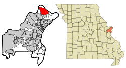
Location of Old Jamestown, Missouri
Coordinates: 38°50′21″N90°16′55″W / 38.83917°N 90.28194°W / 38.83917; -90.28194
Country Flag of the United States (23px).png  United States
State Flag of Missouri.svg Missouri
County St. Louis
Townships Lewis and Clark, Spanish Lake
Area
[1]
  Total
14.96 sq mi (38.73 km2)
  Land14.95 sq mi (38.71 km2)
  Water0.01 sq mi (0.02 km2)
Elevation
[2]
538 ft (164 m)
Population
 (2020)
  Total
19,790
  Density1,324.10/sq mi (511.23/km2)
Time zone UTC-6 (Central (CST))
  Summer (DST) UTC-5 (CDT)
ZIP codes
63033, 63034
Area code(s) 314/557
FIPS code 29-54352 [3]
GNIS feature ID2583784 [2]
Website oldjamestownassn.org

Old Jamestown is an unincorporated community and census-designated place (CDP) in St. Louis County, Missouri, United States. The population was 19,790 at the 2020 census. Old Jamestown is northwest of the city of St. Louis and borders the Missouri River.

Contents

Geography

According to the United States Census Bureau, the CDP has a total area of 14.9 square miles (38.7 km2), of which 0.008 square miles (0.02 km2), or 0.06%, is water. [4] The community is located mostly to the north and west of U.S. Route 67 in northern St. Louis County. West Alton is to the north, across the Missouri River. Florissant is to the southwest, and Black Jack and Spanish Lake are to the south. The CDP is located 17 miles (27 km) north of downtown St. Louis.

Demographics

Historical population
CensusPop.Note
2010 19,184
2020 19,7903.2%
U.S. Decennial Census [5]

Old Jamestown first appeared as a census designated place in the 2010 U.S. Census.

2020 census

Old Jamestown CDP, Missouri – Racial and ethnic composition
Note: the US Census treats Hispanic/Latino as an ethnic category. This table excludes Latinos from the racial categories and assigns them to a separate category. Hispanics/Latinos may be of any race.
Race / Ethnicity (NH = Non-Hispanic)Pop 2010 [6] Pop 2020 [7] % 2010% 2020
White alone (NH)7,9284,83241.33%24.42%
Black or African American alone (NH)10,25313,53153.45%68.37%
Native American or Alaska Native alone (NH)23260.12%0.13%
Asian alone (NH)3363071.75%1.55%
Native Hawaiian or Pacific Islander alone (NH)1130.06%0.02%
Other race alone (NH)341320.18%0.67%
Mixed race or Multiracial (NH)3246361.69%3.21%
Hispanic or Latino (any race)2753231.43%1.63%
Total19,18419,790100.00%100.00%

Education

The vast majority of the CDP is in the Hazelwood School District. A small portion is in the Ferguson-Florissant School District. [8]

References

  1. "ArcGIS REST Services Directory". United States Census Bureau. Retrieved August 28, 2022.
  2. 1 2 U.S. Geological Survey Geographic Names Information System: Old Jamestown, Missouri
  3. "U.S. Census website". United States Census Bureau . Retrieved January 31, 2008.
  4. "Geographic Identifiers: 2010 Demographic Profile Data (G001): Old Jamestown CDP, Missouri". U.S. Census Bureau, American Factfinder. Archived from the original on February 12, 2020. Retrieved January 23, 2013.
  5. "Census of Population and Housing". Census.gov. Retrieved June 4, 2016.
  6. "P2 Hispanic or Latino, and Not Hispanic or Latino by Race – 2010: DEC Redistricting Data (PL 94-171) – Old Jamestown CDP, Missouri". United States Census Bureau .
  7. "P2 Hispanic or Latino, and Not Hispanic or Latino by Race – 2020: DEC Redistricting Data (PL 94-171) – Old Jamestown CDP, Missouri". United States Census Bureau .
  8. Geography Division (January 12, 2021). 2020 CENSUS - SCHOOL DISTRICT REFERENCE MAP: St. Louis County, MO (PDF) (Map). U.S. Census Bureau. p. 2 (PDF p. 3/5). Archived (PDF) from the original on July 22, 2022. Retrieved June 9, 2025. - Text list