Lemay, Missouri

Last updated
Lemay, Missouri
CDP
Lemay, Missouri.jpg
From top left: Lemay Park, River City Casino, South Broadway, Jefferson Barracks Historic District
St. Louis County Missouri Incorporated and Unincorporated areas Lemay Highlighted.svg
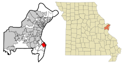
Location of Lemay, Missouri
Coordinates: 38°31′57″N90°17′04″W / 38.53250°N 90.28444°W / 38.53250; -90.28444 Coordinates: 38°31′57″N90°17′04″W / 38.53250°N 90.28444°W / 38.53250; -90.28444
Country United States
State Missouri
County St. Louis
Area
[1]
  Total4.31 sq mi (11.15 km2)
  Land4.09 sq mi (10.59 km2)
  Water0.22 sq mi (0.56 km2)
Elevation
[2]
499 ft (152 m)
Population
 (2020)
  Total17,117
  Density4,185.09/sq mi (1,615.76/km2)
Time zone UTC-6 (Central (CST))
  Summer (DST) UTC-5 (CDT)
ZIP code
63125
Area code 314
FIPS code 29-41438 [3]
GNIS feature ID2393097 [2]

Lemay is a census-designated place (CDP) in south St. Louis County, Missouri, United States. The population was 16,645 at the 2010 census. [4]

Contents

History

Lemay was named after Francois Lemai, who operated a ferry boat across the Meramec River in the early nineteenth century. [5] [6]

Geography

According to the United States Census Bureau, the CDP has a total area of 4.5 square miles (12 km2), of which 4.3 square miles (11 km2) is land and 0.2 square miles (0.52 km2), or 4.19%, is water.

Demographics

Historical population
CensusPop.Note
2020 17,117
U.S. Decennial Census [7]

At the 2000 census there were 17,215 people, 7,186 households, and 4,390 families living in the CDP. The population density was 3,959.0 inhabitants per square mile (1,528.6/km2). There were 7,580 housing units at an average density of 1,743.2 per square mile (673.1/km2). The racial makeup of the CDP was 98.51% White, 0.02% African American, 0.007% Native American, 0.53% Asian, 0.01% Pacific Islander, 0.66% from other races, and 0.96% from two or more races. Hispanic or Latino of any race were 1.03%. [3] Of the 7,186 households 26.5% had children under the age of 18 living with them, 43.6% were married couples living together, 12.6% had a female householder with no husband present, and 38.9% were non-families. 34.3% of households were one person and 16.8% were one person aged 65 or older. The average household size is 2.33 and the average family size was 2.99.

The age distribution was 22.8% under the age of 18, 7.7% from 18 to 24, 27.9% from 25 to 44, 21.4% from 45 to 64, and 20.1% 65 or older. The median age was 39 years. For every 100 females, there were 89.8 males. For every 100 females age 18 and over, there were 84.0 males.

The median household income was $34,559 and the median family income was $41,128. Males had a median income of $31,886 versus $25,388 for females. The per capita income for the CDP was $18,730. About 7.1% of families and 10.4% of the population were below the poverty line, including 13.2% of those under the age of 18 and 11.3% of those ages 65 and older.

Economy

The River City Casino is located in Lemay.

Schools

Hancock is the primary school district in Lemay. Hancock enrolls approximately 1600 students. [8] Hancock High School is located at 229 West Ripa Ave. Hancock Middle School is located at 243 West Ripa Ave. Hancock Elementary School is located at 9101 South Broadway Ave. Hancock Early Childhood Center is located at 9417 South Broadway Ave.

Related Research Articles

<span class="mw-page-title-main">East Rancho Dominguez, California</span> Unincorporated community in California, United States

East Rancho Dominguez, also known as East Compton, is an unincorporated community and census-designated place (CDP) located in southern Los Angeles County, California. The population was 15,135 at the 2010 census, up from 9,286 at the 2000 census. East Rancho Dominguez is an accepted city name according to the USPS, and shares the 90221 ZIP Code with Compton.

<span class="mw-page-title-main">West Carson, California</span> Place in California, United States

West Carson is an unincorporated community in Los Angeles County, California. The population was 21,699 at the 2010 census, up from 21,138 at the 2000 census. For statistical purposes, the United States Census Bureau has defined West Carson as a census-designated place (CDP).

<span class="mw-page-title-main">Michigamme, Michigan</span> Place in Michigan, United States

Michigamme is an unincorporated community in Marquette County in the U.S. state of Michigan. It is located within Michigamme Township on the north shores of Lake Michigamme. For statistical purposes, the United States Census Bureau has defined Michigamme as a census-designated place (CDP). The CDP had a population of 255 at the 2020 census.

<span class="mw-page-title-main">Shoreline Park, Mississippi</span> Former CDP in Mississippi, United States

Shoreline Park is a former census-designated place (CDP) in Hancock County, Mississippi. It is part of the Gulfport–Biloxi, Mississippi Metropolitan Statistical Area. The population was 4,058 at the 2000 census. It was not included in the 2010 census. The area is now largely within the city limits of Bay St. Louis, although some of the western side of the former CDP is still unincorporated after Hurricane Katrina in 2005.

<span class="mw-page-title-main">Spokane, Missouri</span> Census-designated place in Missouri, United States

Spokane is a census-designated place in Christian County, Missouri, United States. The population was 177 at the 2010 census. It is part of the Springfield, Missouri, Metropolitan Statistical Area.

<span class="mw-page-title-main">Gray Summit, Missouri</span> Census-designated place in Missouri, United States

Gray Summit is an unincorporated community and census-designated place (CDP) in Franklin County, Missouri, United States. The population was 2,701 at the 2010 census. Also called "Gray's Summit", it was founded by Daniel Gray of New York, who built a hotel here in 1845. It is located on Missouri Route 100 just north of Interstate 44.

<span class="mw-page-title-main">Villa Ridge, Missouri</span> Census-designated place in Missouri, United States

Villa Ridge is an unincorporated community and census-designated place (CDP) in Franklin County, Missouri, United States. The population was 2,636 at the 2010 census, up from 2,417 at the 2000 census.

<span class="mw-page-title-main">High Ridge, Missouri</span> Census-designated place in Missouri, United States

High Ridge is an unincorporated community and census-designated place (CDP) in Jefferson County, Missouri, United States. The population was 4,305 at the 2010 census. At 927 feet (283 m) above sea level, High Ridge is the second-highest point in Jefferson County, second only to Sun Ridge, north of Hillsboro, according to data from the House Springs/Hillsboro 7.5 minute topographic quadrangles. The Beaumont Scout Reservation, a property of the Greater St. Louis Area Council, Boy Scouts of America, is 4 miles (6 km) north of High Ridge.

<span class="mw-page-title-main">Imperial, Missouri</span> Census-designated place in Missouri, United States

Imperial is a census-designated place (CDP) in Jefferson County, Missouri, United States, and is a suburb of St. Louis. The population was 4,947 at the 2020 census. Imperial was originally known as West Kimmswick, the historic Catholic church of St. John’s in Imperial, became an independent parish in 1869.

<span class="mw-page-title-main">Affton, Missouri</span> Census-designated place in Missouri, United States

Affton is a census-designated place (CDP) in south St. Louis County, Missouri, United States, near St. Louis. The population was 20,417 at the 2020 United States Census.

<span class="mw-page-title-main">Mehlville, Missouri</span> CDP in Missouri, United States

Mehlville is a census-designated place (CDP) in south St. Louis County, Missouri, United States, an area locally known as "South County". It is an inner-ring suburb of St. Louis, and part of the Greater St. Louis metropolitan area.

<span class="mw-page-title-main">Oakville, Missouri</span> CDP in Missouri, United States

Oakville is a census-designated place (CDP) in south St. Louis County, Missouri, United States. The population was 36,301 at the 2020 census. Oakville is 18 miles south of the city of St. Louis and borders the Mississippi and Meramec rivers; the area is part of "South County".

<span class="mw-page-title-main">Sappington, Missouri</span> CDP in Missouri, United States

Sappington is an unincorporated census-designated place in St. Louis County, Missouri, United States. The population was 7,995 at the 2020 census.

<span class="mw-page-title-main">Concord, Missouri</span> CDP in Missouri, United States

Concord is a census-designated place (CDP) in St. Louis County, Missouri, United States. The population was 16,421 at the 2010 census. It should not be confused with Concord Township; which the CDP shares much land with, but these areas' boundaries are not identical.

<span class="mw-page-title-main">Spanish Lake, Missouri</span> Census-designated place in Missouri, United States

Spanish Lake is a census-designated place (CDP) in St. Louis County, Missouri, United States. The population was 18,413 at the 2020 census.

<span class="mw-page-title-main">Wynantskill, New York</span> CDP in New York, United States

Wynantskill is a census-designated place (CDP) in Rensselaer County, New York, United States. The population was 3,276 at the 2010 census. Wynantskill is located at the northern town line and the northeastern corner of the town of North Greenbush. The community is a suburb of Troy. state route 66 is the main route through the community. Wynantskill has a major grocery store, several banks and restaurants, a craft beverage store, convenience stores, a post office, and a bowling alley, with almost all houses located on side streets off Main Ave. Other major roads are Whiteview Road, a primarily residential road that leads to US 4; and West Sand Lake Road.

<span class="mw-page-title-main">Newell, West Virginia</span> Census-designated place in West Virginia, United States

Newell is an unincorporated community and census-designated place in northern Hancock County, West Virginia, United States, situated along the Ohio River. The population was 1,203 at the 2020 census. It is a part of the Weirton–Steubenville metropolitan area. Newell is home to the Fiesta Tableware Company and the Mountaineer Casino, Racetrack and Resort.

<span class="mw-page-title-main">Shell Knob, Missouri</span> Census-designated place in Missouri, United States

Shell Knob is a census-designated place (CDP) located within White River Township, Barry County, Missouri. The population was 1,254 at the 2020 census.

<span class="mw-page-title-main">Hancock (CDP), New Hampshire</span> Census-designated place in New Hampshire, United States

Hancock is a census-designated place (CDP) and the main village in the town of Hancock in Hillsborough County, New Hampshire, United States. The population of the CDP was 213 at the 2020 census, out of 1,731 in the entire town.

Bucksport is a census-designated place (CDP) in the town of Bucksport in Hancock County, Maine, United States. The population was 2,885 at the 2010 census, down from 2,970 at the 2000 census.

References

  1. "ArcGIS REST Services Directory". United States Census Bureau. Retrieved August 28, 2022.
  2. 1 2 U.S. Geological Survey Geographic Names Information System: Lemay, Missouri
  3. 1 2 "U.S. Census website". United States Census Bureau . Retrieved 2008-01-31.
  4. "Race, Hispanic or Latino, Age, and Housing Occupancy: 2010 Census Redistricting Data (Public Law 94-171) Summary File (QT-PL), Lemay CDP, Missouri". United States Census Bureau . Retrieved October 26, 2011.
  5. http://www.frontdoor.com/city-guide/lemay-mo-usa.{{cite web}}: Missing or empty |title= (help)
  6. "Missouri Cities and Towns - Relocating, Retiring, Reviews, Ratings". www.boomerater.com.
  7. "Census of Population and Housing". Census.gov. Retrieved June 4, 2016.
  8. "Hancock School District". Archived from the original on 2013-09-05. Retrieved 2013-09-05.