Lancaster, Missouri

Last updated

Lancaster, Missouri
LancasterMoCityHall.jpg
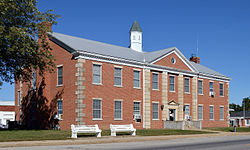
Lancaster City Hall
Schuyler County Missouri Incorporated and Unincorporated areas Lancaster Highlighted.svg
Location of Lancaster, Missouri
Coordinates: 40°31′26″N92°31′53″W / 40.52389°N 92.53139°W / 40.52389; -92.53139
Country United States
State Missouri
County Schuyler
Area
[1]
  Total1.49 sq mi (3.86 km2)
  Land1.49 sq mi (3.85 km2)
  Water0.01 sq mi (0.01 km2)
Elevation
[2]
942 ft (287 m)
Population
 (2020)
  Total675
  Density454.24/sq mi (175.33/km2)
Time zone UTC-6 (Central (CST))
  Summer (DST) UTC-5 (CDT)
ZIP code
63548
Area code 660
FIPS code 29-40610 [3]
GNIS feature ID2395624 [2]

Lancaster is a city in Schuyler County, Missouri, United States. As of the 2020 census, its population was 675. [4] It is the county seat of Schuyler County. [5]

Contents

Lancaster is part of the Kirksville Micropolitan Statistical Area.

History

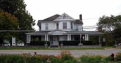
William P. Hall home in Lancaster. It now serves as the Schuyler County Historical Society museum. WilliamPHallHouse1.jpg
William P. Hall home in Lancaster. It now serves as the Schuyler County Historical Society museum.
Schuyler County court house in Lancaster Schuyler County Missouri Courthouse 20151003-028.jpg
Schuyler County court house in Lancaster

A post office called Lancaster has been in operation since 1846. [6] According to one tradition, the community was named after Lancaster, Ohio, the former home of a first settler. [7]

The William P. Hall House was added to the National Register of Historic Places in 1975. [8]

Geography

Lancaster is located at 40°31′27″N92°31′45″W / 40.52417°N 92.52917°W / 40.52417; -92.52917 (40.524087, -92.529190). [9] According to the United States Census Bureau, the city has a total area of 1.50 square miles (3.88 km2), of which 1.49 square miles (3.86 km2) is land and 0.01 square miles (0.03 km2) is water. [10]

Demographics

Historical population
CensusPop.Note
1870 427
1880 52823.7%
1890 81153.6%
1900 98020.8%
1910 964−1.6%
1920 859−10.9%
1930 807−6.1%
1940 8869.8%
1950 856−3.4%
1960 740−13.6%
1970 82110.9%
1980 8554.1%
1990 785−8.2%
2000 737−6.1%
2010 728−1.2%
2020 675−7.3%
U.S. Decennial Census [11]

2010 census

At the 2010 census there were 728 people, 326 households, and 187 families living in the city. The population density was 488.6 inhabitants per square mile (188.6/km2). There were 367 housing units at an average density of 246.3 per square mile (95.1/km2). The racial makup of the city was 98.2% White, 0.5% Asian, 0.1% from other races, and 1.1% from two or more races. Hispanic or Latino of any race were 0.7%. [12]

Of the 326 households 29.4% had children under the age of 18 living with them, 39.6% were married couples living together, 14.1% had a female householder with no husband present, 3.7% had a male householder with no wife present, and 42.6% were non-families. 38.0% of households were one person and 20.8% were one person aged 65 or older. The average household size was 2.23 and the average family size was 2.96.

The median age was 38.3 years. 26.2% of residents were under the age of 18; 8.2% were between the ages of 18 and 24; 22.6% were from 25 to 44; 22.9% were from 45 to 64; and 20.2% were 65 or older. The gender makeup of the city was 46.4% male and 53.6% female.

2000 census

At the 2000 census there were 737 people, 319 households, and 203 families living in the city. The population density was 494.7 inhabitants per square mile (191.0/km2). There were 370 housing units at an average density of 248.4 per square mile (95.9/km2). The racial makup of the city was 99.46% White, 0.14% Native American, 0.14% Pacific Islander, 0.27% from other races. Hispanic or Latino of any race were 0.41%. [3]

Of the 319 households 29.5% had children under the age of 18 living with them, 51.7% were married couples living together, 10.7% had a female householder with no husband present, and 36.1% were non-families. 33.5% of households were one person and 21.6% were one person aged 65 or older. The average household size was 2.31 and the average family size was 2.93.

The age distribution was 25.4% under the age of 18, 7.7% from 18 to 24, 23.7% from 25 to 44, 19.7% from 45 to 64, and 23.5% 65 or older. The median age was 40 years. For every 100 females, there were 80.2 males. For every 100 females age 18 and over, there were 77.4 males.

The median household income was $27,202 and the median family income was $37,083. Males had a median income of $28,889 versus $19,063 for females. The per capita income for the city was $14,263. About 13.8% of families and 18.9% of the population were below the poverty line, including 29.3% of those under age 18 and 9.5% of those age 65 or over.

Education

Lancaster has a public library, the Schuyler County Library District. [13]

Notable people

Related Research Articles

<span class="mw-page-title-main">Schuyler County, Missouri</span> County in Missouri, United States

Schuyler County is a county located in the northeastern portion of the U.S. state of Missouri. As of the 2020 census, its population was 4,032, making it the fourth-least populous county in Missouri. Its county seat is Lancaster. The county was organized February 14, 1845, from Adair County, and named for General Philip Schuyler, delegate to the Continental Congress and U.S. Senator from New York.

<span class="mw-page-title-main">Melba, Idaho</span> Village in Idaho, United States

Melba is a village in Canyon County, Idaho. The population was 513 at the time of the 2010 census, up from 439 in 2000. It is part of the Boise metropolitan area.

<span class="mw-page-title-main">Fillmore, Missouri</span> City in Missouri, United States

Fillmore is a city in Andrew County, Missouri, United States. The population was 173 at the 2020 census.

<span class="mw-page-title-main">Rea, Missouri</span> City in Missouri, United States

Rea is a city in Andrew County, Missouri, United States. The population was 46 at the 2020 census. It is part of the St. Joseph, MO–KS Metropolitan Statistical Area.

<span class="mw-page-title-main">Mosby, Missouri</span> City in Missouri, United States

Mosby is a city in Clay County, Missouri, United States, along the Fishing River. The population was 101 at the 2020 census. It is part of the Kansas City metropolitan area.

<span class="mw-page-title-main">St. Thomas, Missouri</span> City in Missouri, United States

St. Thomas is a city in Cole County, Missouri, United States. The population was 222 at the 2020 census. It is part of the Jefferson City, Missouri Metropolitan Statistical Area.

<span class="mw-page-title-main">Coffey, Missouri</span> City in Missouri, United States

Coffey is a city in northern Daviess County, Missouri, United States. The population was 151 at the 2020 census.

<span class="mw-page-title-main">Morrison, Missouri</span> City in Missouri, United States

Morrison is a city in Gasconade County, Missouri, United States. The first permanent settlement in the town was made by Robert Shobe circa 1828. The population was 93 at the 2020 census.

<span class="mw-page-title-main">New Hampton, Missouri</span> City in Missouri, United States

New Hampton is a city in southwest Harrison County, Missouri, United States. The population was 228 at the 2020 census.

<span class="mw-page-title-main">Weaubleau, Missouri</span> City in Missouri, United States

Weaubleau is a city in Hickory County, Missouri, United States, founded in 1867. The population was 378 at the 2020 census.

<span class="mw-page-title-main">Wheatland, Missouri</span> City in Missouri, United States

Wheatland is a city in Hickory County, Missouri, United States. The population was 277 at the 2020 census.

<span class="mw-page-title-main">Levasy, Missouri</span> City in Missouri, United States

Levasy is a city in Jackson County, Missouri, United States. The population was 83 at the 2010 census. It is part of the Kansas City metropolitan area.

<span class="mw-page-title-main">Mayview, Missouri</span> City in Missouri, United States

Mayview is a city in Lafayette County, Missouri, and part of the Kansas City metropolitan area within the United States. The population was 211 at the 2010 census.

<span class="mw-page-title-main">Winfield, Missouri</span> City in Missouri, United States

Winfield is a city in Lincoln County, Missouri, United States. The population was 1,404 at the 2010 census.

<span class="mw-page-title-main">Tarrants, Missouri</span> Village in Missouri, United States

Tarrants is a village in central Pike County, Missouri, United States. The population was 22 at the 2010 census.

<span class="mw-page-title-main">Livonia, Missouri</span> Village in Missouri, United States

Livonia is a village in eastern Putnam County, Missouri, United States. The population was 52 at the 2020 census.

<span class="mw-page-title-main">Wood Heights, Missouri</span> City in Missouri, United States

Wood Heights is a city in western Ray County, Missouri, and part of the Kansas City metropolitan area within the United States. The population was 757 at the 2020 census.

<span class="mw-page-title-main">Calverton Park, Missouri</span> City in Missouri, United States

Calverton Park is a city in St. Louis County, Missouri, United States. The population was 1,293 at the 2010 census. The Village of Calverton Park incorporated as the City of Calverton Park in 2014.

<span class="mw-page-title-main">Snyder, Nebraska</span> Village in Nebraska, United States

Snyder is a village in Dodge County, Nebraska, United States. The population was 300 at the 2010 census.

<span class="mw-page-title-main">Greentop, Missouri</span> City in Missouri, United States

Greentop is a city in Adair and Schuyler counties, Missouri, United States. As of the 2020 census, its population was 388.

References

  1. "ArcGIS REST Services Directory". United States Census Bureau. Retrieved August 28, 2022.
  2. 1 2 U.S. Geological Survey Geographic Names Information System: Lancaster, Missouri
  3. 1 2 "U.S. Census website". United States Census Bureau . Retrieved January 31, 2008.
  4. "2020: DEC Redistricting Data (PL 94-171)". United States Census Bureau . Retrieved November 18, 2021.
  5. "Find a County". National Association of Counties. Retrieved June 7, 2011.
  6. "Post Offices". Jim Forte Postal History. Retrieved December 12, 2016.
  7. "Schuyler County Place Names, 1928–1945". The State Historical Society of Missouri. Archived from the original on June 24, 2016. Retrieved December 23, 2016.
  8. "National Register Information System". National Register of Historic Places . National Park Service. July 9, 2010.
  9. "US Gazetteer files: 2010, 2000, and 1990". United States Census Bureau. February 12, 2011. Retrieved April 23, 2011.
  10. "US Gazetteer files 2010". United States Census Bureau. Archived from the original on July 2, 2012. Retrieved July 8, 2012.
  11. "Census of Population and Housing". Census.gov. Retrieved June 4, 2015.
  12. "U.S. Census website". United States Census Bureau . Retrieved July 8, 2012.
  13. "Missouri Public Libraries". PublicLibraries.com. Archived from the original on June 10, 2017. Retrieved June 2, 2019.