Perryville, Missouri

Last updated

Perryville, Missouri
Perryville, Missouri County Court House 1 retouched.jpg
Perry County Court House
Perry County Missouri Incorporated and Unincorporated areas Perryville Highlighted.svg
Location of Perryville, Missouri
Coordinates: 37°43′41″N89°51′40″W / 37.72806°N 89.86111°W / 37.72806; -89.86111 [1]
Country United States
State Missouri
County Perry
Township Central
Incorporated 1856
Government
  MayorLarry Riney [2]
Area
[3]
  Total8.32 sq mi (21.56 km2)
  Land8.16 sq mi (21.14 km2)
  Water0.16 sq mi (0.43 km2)
Elevation
[1]
577 ft (176 m)
Population
 (2020)
  Total8,555
  Density1,048.41/sq mi (404.78/km2)
Time zone UTC-6 (Central (CST))
  Summer (DST) UTC-5 (CDT)
ZIP codes
63775, 63776, 63783
Area code 573
FIPS code 29-57116 [4]
GNIS feature ID2396186 [1]
Website https://www.cityofperryville.com
Perryville has a Mayfest once a year

Perryville is a city in Perry County, Missouri, United States. The population was 8,555 at the 2020 United States census. Perryville is the county seat of Perry County. [5]

Contents

History

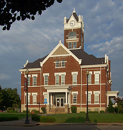
Perryville was selected the county seat of Perry County by Robert T. Brown, Joseph Tucker, and Thomas Riney, who had been appointed to select the seat of justice. [6] In 1821, Bernard Layton deeded 51 acres (210,000 m2) to the commissioners in exchange for one town lot. Fifty-three of the 99 town lots were sold for $1,486.25, which was used to build the first courthouse. The current courthouse is the third such structure. It was built in 1904 at a cost of $30,000. Perryville and Perry County were named for Commodore Oliver Hazard Perry, Naval hero of the War of 1812. [7] [8]

An early store in Perryville was a log structure built by Jean Ferdinand Rozier on the north side of the square. [9] An extant two-story brick building was built in 1830. The upper story serves as the first town hall. Perryville was first incorporated in 1837, but the incorporation was allowed to lapse.[ citation needed ]

As both merchandisers and consumers grew in sophistication, so did the types of establishments in the county. Built in 1843, the Hoose Hotel, often called the "white house", [5] was a prominent structure in early commercial days. The Hoose Hotel served as a hotel, a brewery and an auction block.[ citation needed ]

In 1856, the town was again incorporated and by 1874 it had its first fire engine. Fourth Class City status was attained in 1879 and the following year Charles A. Weber was elected its first mayor. [10] With the building of the Chester, Perryville and Ste. Genevieve Railway, prosperity came.

Largely because of its role as the seat of county government and because of its central location, Perryville began to develop as the major commercial and service center in Perry County. The population increased from 897 in 1890 to 1275 in 1900. Telephone service started in 1893. [11]

2017 tornado

On February 28, 2017, an EF4 tornado tore through Perryville, causing widespread EF3 and some EF4 damage in and around the city. One person was killed.

Geography

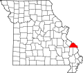
Perryville is located in central Perry County approximately seven miles from the Mississippi River. Cinque Hommes Creek flows past the south side of the city. I-55 and U.S. Route 61 pass on the west and east sides of the city respectively. [12]

According to the United States Census Bureau, the city has a total area of 7.96 square miles (20.62 km2), of which 7.80 square miles (20.20 km2) is land and 0.16 square miles (0.41 km2) is water. [13]

Climate

Climate data for Perryville Water Treatment Plant, Missouri (1991–2020 normals, extremes 1907–present)
MonthJanFebMarAprMayJunJulAugSepOctNovDecYear
Record high °F (°C)74
(23)
83
(28)
89
(32)
92
(33)
98
(37)
110
(43)
108
(42)
109
(43)
104
(40)
96
(36)
86
(30)
78
(26)
110
(43)
Mean maximum °F (°C)64.0
(17.8)
70.0
(21.1)
77.7
(25.4)
83.3
(28.5)
88.9
(31.6)
94.6
(34.8)
97.8
(36.6)
97.2
(36.2)
92.8
(33.8)
85.3
(29.6)
74.5
(23.6)
64.6
(18.1)
99.7
(37.6)
Mean daily maximum °F (°C)41.0
(5.0)
46.2
(7.9)
56.1
(13.4)
67.5
(19.7)
76.5
(24.7)
85.2
(29.6)
88.3
(31.3)
87.2
(30.7)
80.7
(27.1)
69.6
(20.9)
55.6
(13.1)
44.8
(7.1)
66.6
(19.2)
Daily mean °F (°C)31.2
(−0.4)
35.4
(1.9)
44.4
(6.9)
54.8
(12.7)
64.7
(18.2)
73.8
(23.2)
77.2
(25.1)
75.3
(24.1)
67.8
(19.9)
56.4
(13.6)
44.2
(6.8)
35.1
(1.7)
55.0
(12.8)
Mean daily minimum °F (°C)21.3
(−5.9)
24.6
(−4.1)
32.7
(0.4)
42.1
(5.6)
52.8
(11.6)
62.3
(16.8)
66.1
(18.9)
63.5
(17.5)
54.8
(12.7)
43.3
(6.3)
32.9
(0.5)
25.4
(−3.7)
43.5
(6.4)
Mean minimum °F (°C)1.4
(−17.0)
6.9
(−13.9)
15.2
(−9.3)
27.4
(−2.6)
37.8
(3.2)
49.1
(9.5)
54.8
(12.7)
52.4
(11.3)
39.5
(4.2)
27.4
(−2.6)
18.1
(−7.7)
8.2
(−13.2)
−2.6
(−19.2)
Record low °F (°C)−16
(−27)
−19
(−28)
0
(−18)
17
(−8)
28
(−2)
37
(3)
38
(3)
35
(2)
29
(−2)
4
(−16)
−5
(−21)
−13
(−25)
−19
(−28)
Average precipitation inches (mm)2.74
(70)
2.77
(70)
3.82
(97)
5.53
(140)
5.71
(145)
4.34
(110)
3.93
(100)
3.33
(85)
3.33
(85)
3.39
(86)
4.18
(106)
3.16
(80)
46.23
(1,174)
Average snowfall inches (cm)1.3
(3.3)
1.7
(4.3)
0.5
(1.3)
0.0
(0.0)
0.0
(0.0)
0.0
(0.0)
0.0
(0.0)
0.0
(0.0)
0.0
(0.0)
0.0
(0.0)
0.1
(0.25)
1.1
(2.8)
4.7
(12)
Average precipitation days (≥ 0.01 in)5.75.98.69.310.97.67.67.06.16.87.56.889.8
Average snowy days (≥ 0.1 in)0.70.80.20.00.00.00.00.00.00.00.10.62.4
Source: NOAA [14] [15]

Demographics

Historical population
CensusPop.Note
1850 177
1860 33689.8%
1870 50149.1%
1880 75450.5%
1890 87516.0%
1900 1,27545.7%
1910 1,70834.0%
1920 1,7633.2%
1930 2,96468.1%
1940 3,90731.8%
1950 4,59117.5%
1960 5,11711.5%
1970 5,1490.6%
1980 7,34342.6%
1990 6,933−5.6%
2000 7,66710.6%
2010 8,2257.3%
2020 8,5554.0%
U.S. Decennial Census [16]

2020 census

The 2020 United States census [17] counted 8,555 people, 3,357 households, and 2,107 families in Perryville. The population density was 1,048.4 per square mile (404.7/km2). There were 3,717 housing units at an average density of 455.5 per square mile (175.8/km2). The racial makeup was 90.3% (7,725) white, 0.95% (81) black or African-American, 0.3% (26) Native American, 1.17% (100) Asian, 0.0% (0) Pacific Islander, 1.8% (154) from other races, and 5.48% (469) from two or more races. Hispanic or Latino of any race was 3.4% (290) of the population.

Of the 3,357 households, 29.2% had children under the age of 18; 48.0% were married couples living together; 30.8% had a female householder with no husband present. Of all households, 30.9% consisted of individuals and 12.2% had someone living alone who was 65 years of age or older. The average household size was 2.4 and the average family size was 3.0.

24.4% of the population was under the age of 18, 8.2% from 18 to 24, 23.4% from 25 to 44, 25.6% from 45 to 64, and 17.8% who were 65 years of age or older. The median age was 39.8 years. For every 100 females, the population had 85.4 males. For every 100 females ages 18 and older, there were 81.1 males.

The 2016-2020 5-year American Community Survey [18] estimates show that the median household income was $51,601 (with a margin of error of +/- $3,622) and the median family income was $74,393 (+/- $11,149). Males had a median income of $40,898 (+/- $7,484) versus $23,831 (+/- $3,006) for females. The median income for those above 16 years old was $31,694 (+/- $2,690). Approximately, 9.9% of families and 12.8% of the population were below the poverty line, including 13.8% of those under the age of 18 and 4.3% of those ages 65 or over.

2010 census

As of the census [19] of 2010, there were 8,225 people, 3,288 households, and 2,078 families living in the city. The population density was 1,054.5 inhabitants per square mile (407.1/km2). There were 3,588 housing units at an average density of 460.0 per square mile (177.6/km2). The racial makeup of the city was 95.33% White, 0.75% Black or African American, 0.39% Native American, 0.90% Asian, 0.07% Native Hawaiian or Pacific Islander, 1.28% from other races, and 1.28% from two or more races. Hispanic or Latino of any race were 2.69% of the population.

There were 3,288 households, of which 33.3% had children under the age of 18 living with them, 45.5% were married couples living together, 12.3% had a female householder with no husband present, 5.4% had a male householder with no wife present, and 36.8% were non-families. 31.1% of all households were made up of individuals, and 14.4% had someone living alone who was 65 years of age or older. The average household size was 2.42 and the average family size was 3.00.

The median age in the city was 36.5 years. 25.4% of residents were under the age of 18; 8.4% were between the ages of 18 and 24; 25.6% were from 25 to 44; 22.9% were from 45 to 64; and 17.7% were 65 years of age or older. The gender makeup of the city was 47.7% male and 52.3% female.

2000 census

As of the census [4] of 2000, there were 7,667 people, 3,031 households, and 1,991 families living in the city. The population density was 1,010.3 inhabitants per square mile (390.1/km2). There were 3,284 housing units at an average density of 432.7 per square mile (167.1/km2). The racial makeup of the city was 97.47% White, 1.32% Asian, 0.25% African American, 0.17% Native American, 0.01% Pacific Islander, 0.16% from other races, and 0.63% from two or more races. Hispanic or Latino of any race were 0.70% of the population.

There were 3,031 households, out of which 31.7% had children under the age of 18 living with them, 51.4% were married couples living together, 11.2% had a female householder with no husband present, and 34.3% were non-families. 30.4% of all households were made up of individuals, and 15.6% had someone living alone who was 65 years of age or older. The average household size was 2.41 and the average family size was 3.00.

In the city the population was spread out, with 24.6% under the age of 18, 9.2% from 18 to 24, 28.2% from 25 to 44, 18.5% from 45 to 64, and 19.5% who were 65 years of age or older. The median age was 37 years. For every 100 females there were 89.7 males. For every 100 females age 18 and over, there were 86.9 males.

The median income for a household in the city was $33,934, and the median income for a family was $43,072. Males had a median income of $27,115 versus $19,736 for females. The per capita income for the city was $16,630. About 5.9% of families and 11.0% of the population were below the poverty line, including 10.6% of those under age 18 and 15.9% of those age 65 or over.

Economy

Two of the largest employers in the city are TG Missouri, a division of Toyoda Gosei, and Gilster-Mary Lee.

Manufacturers in Perryville include:

Arts and culture

Festivals

Two festivals are held annually in Perryville, Mayfest which is held on the courthouse square in May, and the St. Vincent de Paul Seminary Picnic which is held on the seminary fairgrounds each August. [21] [22]

Historic sites

Shelby-Nicholson-Schindler House Shelby-Nicholson-Schindler House.JPG
Shelby–Nicholson–Schindler House

Three sites listed on the National Register of Historic Places are located in Perryville, including the Doerr–Brown House, St. Mary's of the Barrens Catholic Church, and the Shelby–Nicholson–Schindler House.

Churches

Perryville is home to a number of churches, of which three of the largest churches are St. Vincent de Paul Roman Catholic Church, St. Mary's of the Barrens Roman Catholic Church, Immanuel Lutheran Church, the First Presbyterian Church, First Baptist Church, Calvary Baptist Church, United Methodist Church, Agape Christian Assembly of God Church, First Assembly of God Church, Christ of Christ. [23]

Parks and recreation

The Perry Park Center, located in the city park, features an aquatics center, gymnasium, performing arts center, movie theatre, library, and sports facilities. [24]

Government

Perryville has a mayor/city council form of government. The mayor is Larry Riney. [25] The city council consists of six aldermen, two from each of three wards. Each is elected for two-year terms. [26]

Education

Perryville is served by Perry County School District No. 32 (PK-12) as well as two private parochial school systems: St. Vincent dePaul Catholic School (including St. Vincent High School) and Immanuel Lutheran School (PK-8).

Perryville has a public library, a branch of the Riverside Regional Library. [27]

Infrastructure

The 880th Engineer Team (HAUL) of the Missouri Army National Guard is based in Perryville.

Perry County Memorial Hospital is the health provider for the city and county.

Notable people

Related Research Articles

<span class="mw-page-title-main">Madison County, Missouri</span> County in Missouri, United States

Madison County is a county located in the Lead Belt region of the U.S. state of Missouri. As of the 2020 census, the population was 12,626. Its county seat and largest city is Fredericktown. The county was officially organized on December 14, 1818, and was named after President James Madison.

<span class="mw-page-title-main">Perry County, Arkansas</span> County in Arkansas, United States

Perry County is a county located in the U.S. state of Arkansas. Its population was 10,019 at the 2020 United States Census. The county seat is Perryville. The county was formed on December 18, 1840, and named for Commodore Oliver Hazard Perry, naval hero in the War of 1812. It is an alcohol prohibition or dry county.

<span class="mw-page-title-main">Perryville, Alaska</span> Census-designated place in Alaska, United States

Perryville is a census-designated place (CDP) in Lake and Peninsula Borough, Alaska, United States. The population was 88 at the 2020 census, down from 113 in 2010.

<span class="mw-page-title-main">Perryville, Arkansas</span> City in Arkansas, United States

Perryville is a city in and the county seat of Perry County, Arkansas, United States. The population was 1,460 at the 2010 census, an increase of just two persons from 2000. It is part of the Little Rock–North Little Rock–Conway Metropolitan Statistical Area.

<span class="mw-page-title-main">Perryville, Kentucky</span> City in Kentucky, United States

Perryville is a home rule-class city along the Chaplin River in western Boyle County, Kentucky, in the United States. The population was 751 at the time of the 2010 U.S. Census. It is part of the Danville Micropolitan Statistical Area.

<span class="mw-page-title-main">North East, Maryland</span> Town in Maryland, United States

North East is a town in Cecil County, Maryland, United States. It is located between Philadelphia and Baltimore. The population was 3,572 at the 2010 census.

<span class="mw-page-title-main">Perryville, Maryland</span> Town in Maryland, United States

Perryville is a town in Cecil County, Maryland, United States. The population was 4,361 at the 2010 census. The town is located near an exit for Interstate 95, on the north side of the outlet of the Susquehanna River.

<span class="mw-page-title-main">Maysville, Missouri</span> City in Missouri, United States

Maysville is a city in DeKalb County, Missouri, United States. The population was 1,095 at the 2020 census. Maysville is the county seat of DeKalb County.

<span class="mw-page-title-main">Berger, Missouri</span> City in Missouri, United States

Berger is a city in northwest Franklin County, Missouri, United States, located south of the Missouri River. The population was 256 at the 2020 census.

<span class="mw-page-title-main">Skidmore, Missouri</span> City in Missouri, United States

Skidmore is a city in western Nodaway County, Missouri, United States. The population was 245 at the 2020 Census. The small farming community is known for the unsolved extrajudicial killing of Ken Rex McElroy, the murders of Wendy Gillenwater and Bobbie Jo Stinnett, and the disappearance of Branson Perry. Skidmore also has a yearly "Punkin' Show."

<span class="mw-page-title-main">Altenburg, Missouri</span> City in Missouri, United States

Altenburg is a city in Perry County, Missouri, United States. The population was 341 at the 2020 census.

<span class="mw-page-title-main">Biehle, Missouri</span> Census-designated place in Missouri, United States

Biehle was a village in Perry County, Missouri, United States. The population was 47 at the 2020 census. The community was founded in 1876 and named after the Biehle family.

<span class="mw-page-title-main">Longtown, Missouri</span> Village in Missouri, United States

Longtown is a village in Union Township in Perry County, Missouri, United States. The population was 90 at the 2020 census.

<span class="mw-page-title-main">Tracy, Missouri</span> City in Missouri, United States

Tracy is a city in Platte County, Missouri within the United States, located along the Platte River. The population was 269 at the 2020 census. The city is part of the Kansas City metropolitan area.

<span class="mw-page-title-main">Perry, Missouri</span> City in Missouri, United States

Perry is a city in southwest Ralls County, Missouri, United States. The population was 665 at the 2020 census. It is part of the Hannibal Micropolitan Statistical Area.

<span class="mw-page-title-main">Miami, Missouri</span> City in Missouri, United States

Miami is a city in Saline County, Missouri, United States. The population was 175 at the 2010 census.

<span class="mw-page-title-main">Schell City, Missouri</span> City in Missouri, United States

Schell City is a city in northeast Vernon County, Missouri, United States. The population was 249 at the 2010 census.

<span class="mw-page-title-main">Junction City, Ohio</span> Village in Ohio, United States

Junction City is a village in Perry County, Ohio, United States. The population was 721 at the 2020 census.

<span class="mw-page-title-main">Perry Township, Clarion County, Pennsylvania</span> Township in Pennsylvania, United States

Perry Township is a township in Clarion County, Pennsylvania, United States. The population was 922 at the 2020 census, a decrease from the figure of 947 tabulated in 2010.

<span class="mw-page-title-main">Dardenne Prairie, Missouri</span> Town in Missouri, United States

Dardenne Prairie is a city in St. Charles County, Missouri, United States. The population was 12,743 at the 2020 census.

References

  1. 1 2 3 U.S. Geological Survey Geographic Names Information System: Perryville, Missouri
  2. "Mayor | Perryville, MO - Official Website".
  3. "ArcGIS REST Services Directory". United States Census Bureau. Retrieved August 28, 2022.
  4. 1 2 "U.S. Census website". United States Census Bureau . Retrieved January 31, 2008.
  5. 1 2 Robert Sidney Douglass (1912). History of Southeast Missouri: A Narrative Account of Its Historical Progress, Its People and Its Principal Interests, Volume 1. ISBN   9780722207536.
  6. State Historical Society of Missouri: Perry County Place Names http://shs.umsystem.edu/manuscripts/ramsay/ramsay_perry.html
  7. The Centennial History of Perry County Missouri 1821-1921 Committee of Citizens 1921 reprinted by the Perry County Historical Society; Perryville MO: 1984
  8. Eaton, David Wolfe (1917). How Missouri Counties, Towns and Streams Were Named. The State Historical Society of Missouri. p. 338.
  9. Walter A. Schroeder (2002). Opening the Ozarks: A Historical Geography of Missouri's Ste. Genevieve District, 1760-1830. ISBN   9780826263063.
  10. Campbell, Robert Allen (1875). Campbell's Gazetteer of Missouri: From Articles Contributed by Prominent Gentlemen in Each County of the State, and Information Collected and Collated from Official and Other Authentic Sources. R. A. Campbell.
  11. "Greatriverroad.com - Perryville, Missouri" . Retrieved December 31, 2015.
  12. Missouri Atlas & Gazetteer, DeLorme, 1st ed., 1998, p. 58 ISBN   0-89933-224-2
  13. "US Gazetteer files 2010". United States Census Bureau. Archived from the original on January 25, 2012. Retrieved July 8, 2012.
  14. "NowData – NOAA Online Weather Data". National Oceanic and Atmospheric Administration. Retrieved July 24, 2021.
  15. "Station: Perryville WTP, MO". U.S. Climate Normals 2020: U.S. Monthly Climate Normals (1991–2020). National Oceanic and Atmospheric Administration. Retrieved July 24, 2021.
  16. "Census of Population and Housing". Census.gov. Retrieved June 4, 2015.
  17. "Explore Census Data". data.census.gov. Retrieved December 17, 2023.
  18. "Explore Census Data". data.census.gov. Retrieved December 17, 2023.
  19. "U.S. Census website". United States Census Bureau . Retrieved July 8, 2012.
  20. "Locations". Gilster-Mary Lee Corporation. Retrieved February 14, 2012.
  21. pcmutual.com http://www.pcmutual.com/calender.htm Archived 2014-03-30 at the Wayback Machine
  22. Southeastmissouri.com http://www.semissourian.com/gallery/15410
  23. AT & T Telephone Book
  24. Perryvillemo.com: Recreation "Perryville recreation facilities" (PDF). Archived from the original (PDF) on March 30, 2014. Retrieved March 30, 2014.
  25. "Mayor | Perryville, MO - Official Website".
  26. "Mayor and Board of Aldermen | Perryville, MO - Official Website". www.cityofperryville.com. Retrieved December 14, 2017.
  27. "Perryville branch". Riverside Regional Library. Retrieved March 17, 2018.
  28. "Capt. Raymond Littge". Historical Marker Database. Archived from the original on June 13, 2021. Retrieved July 2, 2022.