Claryville, Missouri | |
---|---|
Coordinates: 37°53′32″N89°49′44″W / 37.89222°N 89.82889°W | |
Country | United States |
State | Missouri |
County | Perry |
Township | Bois Brule |
Elevation | 374 ft (114 m) |
Time zone | UTC-6 (Central (CST)) |
• Summer (DST) | UTC-5 (CDT) |
ZIP code | 63775 |
Area code | 573 |
FIPS code | 29-14230 [2] |
GNIS feature ID | 735559 [1] |
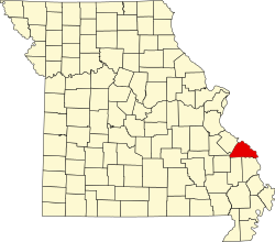
Claryville is an unincorporated community in Bois Brule Township in Perry County, Missouri, United States. It is located twelve miles northeast of Perryville, sixty-three miles south of Saint Louis, and lies adjacent to the Mississippi River.
The spelling of the name was first Clearyville, as it was named for John Cleary, a nearby farmer. The name was eventually changed to correspond to the pronunciation. [3] Claryville was also known unofficially as West Chester. [4]
John W. Clary received the land for his service to the United States of America in the Mexican–American War, under the authority of the ScripWarrant Act of 1847 (9 Stat. 123) He was awarded the maximum amount of land, which was 160 acres, in his grant.
Claryville was first settled in 1869, and the town was platted in 1871. The first mayor was V.P. Tucker and its first merchant was E. J. Rhodes. As of 1912, the town had three general stores and a population of 140. [5] Subsequent floods over the years have diminished the town's population.
Claryville is situated in the Mississippi River Valley within an alluvial flood plain called the Bois Brule Bottom. Its location along the Mississippi River has made Claryville susceptible to flooding.
Perry County is a county located in the southeastern portion of the U.S. state of Missouri. As of the 2020 census, the population was 18,956. Its county seat is Perryville. The county was officially organized on November 16, 1820 from Ste. Genevieve County and was named after Oliver Hazard Perry, a naval hero of the War of 1812.
Kaskaskia is a village in Randolph County, Illinois. Having been inhabited by indigenous peoples, it was settled by France as part of the Illinois Country. It was named for the Kaskaskia people. Its population peaked at about 7,000 in the 18th century, when it was a regional center. During the American Revolutionary War, the town, which by then had become an administrative center for the British Province of Quebec, was taken by the Virginia militia during the Illinois campaign. It was designated as the county seat of Illinois County, Virginia, after which it became part of the Northwest Territory in 1787. Kaskaskia was later named as the capital of the United States' Illinois Territory, created on February 3, 1809. In 1818, when Illinois became the 21st U.S. state, the town briefly served as the state's first capital until 1819, when the capital was moved to more centrally located Vandalia.
Ste. Genevieve is a city in Ste. Genevieve Township and is the county seat of Ste. Genevieve County, Missouri, United States. The population was 4,999 at the 2020 census. Founded in 1735 by French Canadian colonists and settlers from east of the river, it was the first organized European settlement west of the Mississippi River in present-day Missouri. Today, it is home to Ste. Genevieve National Historical Park, the 422nd unit of the National Park Service.
Belgique is an unincorporated community in eastern Perry County, Missouri, United States. It is located approximately five miles south of Chester, Illinois, in Perry County's Bois Brule Township.
Wittenberg is an unincorporated community in Brazeau Township in eastern Perry County, Missouri, United States. It is located on the Mississippi River, 14 miles (23 km) southeast of Perryville. Wittenberg is situated in the Brazeau Bottoms on Brazeau Creek opposite Grand Tower, Illinois, and Tower Rock, the latter a landmark island in the Mississippi River.
Menfro is an unincorporated community in northeastern Perry County, Missouri, United States. It is located 8 miles (13 km) northeast of Perryville.
Cinque Hommes is one of the eight townships located in Perry County, Missouri, in the United States of America.
Seventy-Six was an unincorporated community in Brazeau Township in eastern Perry County, Missouri, United States. It was located fourteen miles east of Perryville, ninety miles south of Saint Louis, and lay directly on the Mississippi River.
Bois Brûlé is one of the eight townships located in Perry County, Missouri, in the United States of America.
McBride is an unincorporated community located in Bois Brule Township in Perry County, Missouri, United States. McBride is located approximately eight miles northeast of Perryville.
Sereno is an unincorporated community located in Bois Brule Township in Perry County, Missouri, United States. Sereno is located approximately five miles northeast of Perryville.
Brazeau is one of the eight townships located in Perry County, Missouri, in the United States of America.
The Bois Brule Bottom is an alluvial floodplain in Bois Brule Township in Perry County, Missouri stretching between Bois Brule Creek to the west and the Mississippi River to the east.
Silver Lake is an unincorporated settlement in Saint Mary's Township in Perry County, Missouri, United States.
The Brazeau Bottom is an alluvial floodplain, also called a 'flat', extending along the Mississippi River in Perry County, Missouri.
Central Township is one of the eight townships located in Perry County, Missouri, United States.
Salem Township is one of the eight townships located in Perry County, Missouri, in the United States of America.
Pointrest was an unincorporated community in Bois Brule Township in Perry County, Missouri, United States.
Le Grand Champ is an alluvial floodplain, also called a bottom, extending along the Mississippi River in Ste. Genevieve County, Missouri.
Bois Brule Creek is a tributary of Cinque Hommes Creek in Perry County, Missouri.