Lithium, Missouri | |
|---|---|
 Location of Lithium, Missouri | |
| Coordinates: 37°49′58″N89°53′05″W / 37.83278°N 89.88472°W | |
| Country | United States |
| State | Missouri |
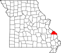
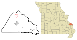
| County | Perry |
| Township | Saline |
| Incorporated | 1883 [1] |
| Area | |
• Total | 0.78 sq mi (2.01 km2) |
| • Land | 0.77 sq mi (1.99 km2) |
| • Water | 0.01 sq mi (0.02 km2) |
| Elevation | 381 ft (116 m) |
| Population (2020) | |
• Total | 92 |
| • Density | 119.48/sq mi (46.14/km2) |
| Time zone | UTC-6 (Central (CST)) |
| • Summer (DST) | UTC-5 (CDT) |
| ZIP code | 63775 |
| Area code | 573 |
| FIPS code | 29-43346 [4] |
| GNIS feature ID | 2398452 [3] |
Lithium is a census-designated place and former village located in Perry County, Missouri, United States. [5] The population was 92 at the 2020 census. The 2000 Census found Lithium to have zero residents; an Associated Press article, however, stated that about 50 people in fact resided there, but may have been counted as part of Perry County's rural population. [6]
Contents
- Etymology
- History
- Geography
- Demographics
- 2010 census
- Gallery
- Location of nearby communities
- References
Lithium had a ZIP Code of 63775, but it has since been declared by the USPS to be "Not Acceptable - Use Perryville."[ citation needed ]