Schalls, Missouri

Last updated
Schalls, Missouri.
Map of Missouri highlighting Perry County.svg
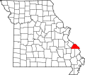
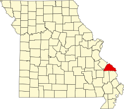
Location of Perry County, Missouri
Coordinates: 37°40′01″N89°41′11″W / 37.66694°N 89.68639°W / 37.66694; -89.68639 Coordinates: 37°40′01″N89°41′11″W / 37.66694°N 89.68639°W / 37.66694; -89.68639
Country United States
State Missouri
County Perry
Township Union
Elevation
620 ft (189 [1]  m)
Time zone UTC-6 (Central (CST))
  Summer (DST) UTC-5 (CDT)
ZIP code
63775
Area code(s) 573
GNIS feature ID726093 [2]

Schalls is an unincorporated community in Union Township in Perry County, Missouri, United States. [3] Schalls is situated in the north-central corner of Perry County. A post office was maintained from 1886 through 1910. The community was named after Maritz Schall, a pioneer stock dealer and farmer. [3] [4] [5]

Unincorporated area Region of land not governed by own local government

In law, an unincorporated area is a region of land that is not governed by a local municipal corporation; similarly an unincorporated community is a settlement that is not governed by its own local municipal corporation, but rather is administered as part of larger administrative divisions, such as a township, parish, borough, county, city, canton, state, province or country. Occasionally, municipalities dissolve or disincorporate, which may happen if they become fiscally insolvent, and services become the responsibility of a higher administration. Widespread unincorporated communities and areas are a distinguishing feature of the United States and Canada. In most other countries of the world, there are either no unincorporated areas at all, or these are very rare; typically remote, outlying, sparsely populated or uninhabited areas.

Union Township, Perry County, Missouri Civil Township in Missouri, United States

Union is one of the eight townships located in Perry County, Missouri, in the United States of America.

Perry County, Missouri County in the United States

Perry County is a county located in the southeastern portion of the U.S. state of Missouri. As of the 2010 census, the population was 18,971. Its county seat is Perryville. The county was officially organized on November 16, 1820 from Ste. Genevieve County and was named after Oliver Hazard Perry, a naval hero of the War of 1812.

Related Research Articles

Clearwater, Missouri unincorporated community in Missouri, United States

Clearwater is an unincorporated community in Saline Township in Sainte Genevieve County, Missouri, United States. It is located approximately fifteen miles southwest of Sainte Genevieve on Missouri Supplemental Route W.

Coffman, Missouri unincorporated community in Missouri, United States

Coffman is an unincorporated community in Saline Township in southern Sainte Genevieve County, Missouri, United States. It is located approximately fifteen miles southwest of Ste. Genevieve.

Menfro, Missouri unincorporated community in Missouri, United States

Menfro is an unincorporated community in northeastern Perry County, Missouri, United States. It is located eight miles (13 km) northeast of Perryville.

Crosstown, Missouri unincorporated community in Missouri, United States

Crosstown, Missouri is an unincorporated settlement situated in Salem Township in Perry County, Missouri, near the Mississippi River.

Cinque Hommes Township, Perry County, Missouri Civil Township in Missouri, United States

Cinque Hommes is one of the eight townships located in Perry County, Missouri, in the United States of America.

Saint Marys Township, Perry County, Missouri Civil Township in Missouri, United States

St. Marys is one of the eight townships located in Perry County, Missouri, in the United States of America.

Capes on the Mississippi River

The term cape has a different tradition of usage in the American Midwest along the Mississippi River. The middle Mississippi River Valley once formed part of the French Colonies of Quebec and Louisiana, also referred to as Upper Louisiana (Haute-Louisiane) or the Illinois Country. The Illinois Country also included the left bank of the Mississippi River in present-day Missouri.

Claryville, Missouri Unincorporated Community in Missouri, United States

Claryville is an unincorporated community in Bois Brule Township in Perry County, Missouri. It is located twelve miles northeast of Perryville, sixty-three miles south of Saint Louis, and lies directly on the Mississippi River.

McBride, Missouri unincorporated community in Missouri, United States

McBride is an unincorporated community located in Bois Brule Township in Perry County, Missouri. McBride is located about eight miles northeast of Perryville, Missouri.

Sereno, Missouri unincorporated community in Missouri, United States

Sereno is an unincorporated community located in Bois Brule Township in Perry County, Missouri, United States. Sereno is located approximately five miles northeast of Perryville.

Yount, Missouri unincorporated community in Missouri, United States

Yount is an unincorporated settlement in Saint Mary's Township in Perry County, Missouri.

Highland, Missouri unincorporated community in Missouri, United States

Highland is an unincorporated community in Cinque Hommes Township in Perry County, Missouri.

Millheim, Missouri unincorporated community in Missouri, United States

Millheim is an unincorporated settlement in Cinque Hommes Township in Perry County, Missouri, United States.

Silver Lake, Missouri unincorporated community in Missouri, United States

Silver Lake is an unincorporated settlement in Saint Mary's Township in Perry County, Missouri, United States.

Seelitz, Missouri Abandoned village in Missouri, United States

Seelitz is an abandoned village in Brazeau Township in Perry County, Missouri, United States.

Dresden, Perry County, Missouri Abandoned village in Missouri, United States

Dresden is an abandoned village in Brazeau Township in Perry County, Missouri, United States.

Corners, Missouri unincorporated community in Missouri, United States

Corners is an unincorporated community in Saint Mary's Township, Perry County, Missouri in Perry County, Missouri. Corners is situated in the southwest corner of Perry County, near the St. Francois County line, northwest of Yount. Presumably the name came from its location in the corner of Perry County, like Crossroads.

Pointrest, Missouri Abandoned village in Missouri, United States

Pointrest was an unincorporated community in Bois Brule Township in Perry County, Missouri, United States.

Barks, Perry County, Missouri unincorporated community in Missouri, United States

Barks is an unincorporated community in south-central St. Mary's Township in Perry County, Missouri. Barks is situated in the northeastern part of Perry County. A post office was established in 1899, and remained in operation until 1919.

Castor, Missouri unincorporated community in Missouri, United States

Castor is an unincorporated community in the northwestern part of Filmore Township in Bollinger County, Missouri. Castor is situated on the Castor River and is located about 16 miles west of Marble Hill, Missouri.

References

  1. Cartographic.usa http://cartographic.info/usa/map.php?id=726093
  2. National Explorer http://nationexplorer.com/feature/726093
  3. 1 2 State Historical Society of Missouri: Perry County http://shs.umsystem.edu/manuscripts/ramsay/ramsay_perry.html
  4. A Directory of Towns, Villages, and Hamlets Past and Present of Perry County, Missouri "Archived copy". Archived from the original on 2013-11-03. Retrieved 2013-11-26.CS1 maint: Archived copy as title (link)
  5. Eaton, David Wolfe (1917). How Missouri Counties, Towns and Streams Were Named. The State Historical Society of Missouri. p. 338.