Schumer Springs, Missouri

Last updated
Schumer Springs, Missouri
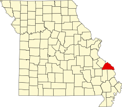
Map of Missouri highlighting Perry County.svg
Location of Perry County, Missouri
Coordinates: 37°36′10″N89°52′38″W / 37.60278°N 89.87722°W / 37.60278; -89.87722 Coordinates: 37°36′10″N89°52′38″W / 37.60278°N 89.87722°W / 37.60278; -89.87722
Country United States
State Missouri
County Perry
Township Cinque Hommes
Elevation
[1]
614 ft (187 m)
Time zone UTC-6 (Central (CST))
  Summer (DST) UTC-5 (CDT)
ZIP code
63775
Area code 573
GNIS feature ID726126 [1]

Schumer Springs is an unincorporated community in southern Cinque Hommes Township in Perry County, Missouri, United States.

History

Schumer Springs is located near a natural mineral spring. The community was presumably named for the spring as well as local proprietors of the spring, namely Henry J. Schumer, a farmer, who lived near Biehle, and Frank P. Schuemer, a miller, who lived in nearby Millheim in 1873. [2] The spring is a rare variety known as an ebb-and-flow spring, and its output varies rhythmically and independently of external moisture conditions. Hydrologists with the Missouri Geological Survey measured the spring's flow in 1963 through 1965 and determined its flow to be at between 6,000 and 258,000 gallons per day. [3] Six men from Jackson, Missouri incorporated a company on September 29, 1905 to establish a mineral bath spa with the intention that the resort might one day become as famous as Hot Springs, Arkansas. They purchased 147 acres and hired civil engineer J.W. Bain to lay the tract into lots. [4] The resort faced financial difficulties within a few years of opening and the account book for the hotel showed operations were in the red despite respectable occupancy. By the time of the Great Depression, much of the town had shut down. [5] A post office was established there in 1908. [6]

Related Research Articles

<span class="mw-page-title-main">Platte River</span> River in Nebraska, United States

The Platte River is a major river in the State of Nebraska. It is about 310 mi (500 km) long; measured to its farthest source via its tributary, the North Platte River, it flows for over 1,050 miles (1,690 km). The Platte River is a tributary of the Missouri River, which itself is a tributary of the Mississippi River which flows to the Gulf of Mexico. The Platte over most of its length is a broad, shallow, meandering stream with a sandy bottom and many islands—a braided stream.

<span class="mw-page-title-main">Spring (hydrology)</span> Point at which water emerges from an aquifer to the surface

A spring is a point of exit at which groundwater from an aquifer flows out on top of Earth's crust (pedosphere) and becomes surface water. It is a component of the hydrosphere. Springs have long been important for humans as a source of fresh water, especially in arid regions which have relatively little annual rainfall.

Siloam Springs is an unincorporated community in western Howell County, Missouri, United States. It is located approximately two miles south of Route 14 on Missouri Route T, just east of the southeastern corner of Douglas County and fifteen miles northwest of West Plains. Waters from the associated spring flow west and enter Tabor Creek, which then flows into Spring Creek, a tributary to the Norfork River in the southeast corner of Douglas County. The site is at an elevation of 1,060 ft (320 m).

Kramer is a small unincorporated community in Liberty Township, Warren County, in the U.S. state of Indiana.

<span class="mw-page-title-main">Belknap Springs, Oregon</span> Unincorporated community in the state of Oregon, United States

Belknap Springs is an unincorporated community and private hot springs resort in Lane County, Oregon, United States, near the McKenzie River. The springs were located and initially developed by R. S. Belknap in 1869. A post office named "Salt Springs" was established in the location in 1874, and the name changed to "Belknap Springs" in 1875. The post office closed in 1877 and reopened in 1891, operating intermittently until 1953. Today the location uses a McKenzie Bridge mailing address.

<span class="mw-page-title-main">Scovern Hot Springs</span> Former settlement in California, United States

Scovern Hot Springs is a thermal spring system, and former settlement in the Kern River Valley of the Southern Sierra Nevada, in Kern County, California.

Pinehurst is an unincorporated community in Jackson County, Oregon, United States, on Oregon Route 66 about 25 miles (40 km) southeast of Ashland. It is along Jenny Creek near Round Prairie between the Siskiyou Mountains and the foothills of the Cascade Range.

<span class="mw-page-title-main">McCredie Springs</span> Unincorporated community in the state of Oregon, United States

McCredie Springs are hot springs and a former resort in Lane County, Oregon, United States. It is located near Oregon Route 58, 10.7 miles (17.2 km) east of Oakridge, and 50.7 miles (81.6 km) east of Eugene, within the Willamette National Forest. It is known for the nearby natural hot springs along Salt Creek.

<span class="mw-page-title-main">Ponce de Leon Springs (Atlanta)</span> Former mineral springs in Atlanta, Georgia

Ponce de Leon Springs was a mineral spring in Atlanta, Georgia, United States. The spring was a popular tourist destination from the mid-1800s through the early 1900s. Around the turn of the century, the land surrounding the spring was developed into an amusement park, though by the 1920s, the amusement park was demolished and the area was developed for industrial and, later, commercial properties.

<span class="mw-page-title-main">Cinque Hommes Township, Perry County, Missouri</span> Civil Township in Missouri, United States

Cinque Hommes is one of the eight townships located in Perry County, Missouri, in the United States of America.

<span class="mw-page-title-main">Apple Creek (Mississippi River tributary)</span> River in Missouri, United States

Apple Creek is a stream that rises in western Perry County, Missouri and empties into the Mississippi River, forming the boundary between Perry and Cape Girardeau counties.

<span class="mw-page-title-main">Mineral Springs, Ohio</span>

Mineral Springs is an unincorporated community in Adams County, Ohio.

Mineral Spring is an unincorporated community in Barry County, in the U.S. state of Missouri.

<span class="mw-page-title-main">Chouteau Springs, Missouri</span>

Chouteau Springs is an unincorporated community in Pilot Grove Township, Cooper County, in the U.S. state of Missouri.

Graydon Springs is an unincorporated community in Polk County, in the U.S. state of Missouri.

Randolph Springs is an unincorporated community in Randolph County, in the U.S. state of Missouri.

Fair Haven is an unincorporated community in Vernon County, in the U.S. state of Missouri.

White is an extinct town in Washington County, in the U.S. state of Missouri. The community was located on Keyes Branch near its confluence with Mill Creek along the railroad line. Cadet lies one mile to the north and Mineral Point is 2.5 south-southeast of the location.

Buckhorn Springs is an unincorporated community in Jackson County, Oregon, United States. It lies along Emigrant Creek in the Siskiyou Mountains southeast of Ashland. Buckhorn Springs Road connects the community to Oregon Route 66 near Emigrant Lake.

Doubling Gap is an unincorporated community in Cumberland County, in the U.S. state of Pennsylvania.

References

  1. 1 2 U.S. Geological Survey Geographic Names Information System: Schumer Springs, Missouri
  2. "State Historical Society of Missouri Place Names – Perry County, Missouri" . Retrieved February 13, 2016.
  3. Loring Bullard (2004). Healing Waters: Missouri's Historic Mineral Springs and Spas. ISBN   9780826264183.
  4. "Out of the Past – 100 years ago". Southeast Missourian. September 8, 2005.
  5. Robert Sidney Douglass (1912). History of Southeast Missouri: A Narrative Account of Its Historical Progress, Its People and Its Principal Interests, Volume 1. ISBN   9780722207536.
  6. Missouri Postal History "Perry". Archived from the original on 2013-10-21. Retrieved 2013-09-19.