Starlanding, Missouri

Last updated
Starlanding, Missouri
Map of Missouri highlighting Perry County.svg
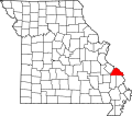
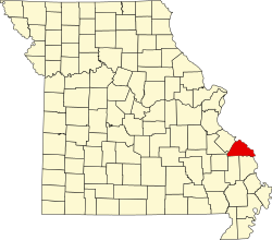
Location of Perry County, Missouri
Coordinates: 37°42′33″N89°35′07″W / 37.70917°N 89.58528°W / 37.70917; -89.58528 Coordinates: 37°42′33″N89°35′07″W / 37.70917°N 89.58528°W / 37.70917; -89.58528
Country United States
State Missouri
County Perry
Township Brazeau
Elevation
364 ft (111 m)
Time zone UTC-6 (Central (CST))
  Summer (DST) UTC-5 (CDT)
ZIP code
63775
Area code(s) 573
FIPS code 29-70440 [1]
GNIS feature ID741285 [1]

Starlanding was an unincorporated community in Brazeau Township in Perry County, Missouri, United States. [2]

Brazeau Township, Perry County, Missouri Civil Township in Missouri, United States

Brazeau is one of the eight townships located in Perry County, Missouri, in the United States of America.

Perry County, Missouri County in the United States

Perry County is a county located in the southeastern portion of the U.S. state of Missouri. As of the 2010 census, the population was 18,971. Its county seat is Perryville. The county was officially organized on November 16, 1820 from Ste. Genevieve County and was named after Oliver Hazard Perry, a naval hero of the War of 1812.

Missouri State of the United States of America

Missouri is a state in the Midwestern United States. With over six million residents, it is the 18th-most populous state of the Union. The largest urban areas are St. Louis, Kansas City, Springfield, and Columbia; the capital is Jefferson City. The state is the 21st-most extensive in area. In the South are the Ozarks, a forested highland, providing timber, minerals, and recreation. The Missouri River, after which the state is named, flows through the center of the state into the Mississippi River, which makes up Missouri's eastern border.

Starlanding was situated in the northern part of Brazeau Township in the eastern part of Perry County, along the Mississippi River at 364 ft. above sea level. [3] The community was originally known as Star Landing, and was founded as a riverboat landing. Today, nothing remains of the town. [4]

Mississippi River largest river system in North America

The Mississippi River is the second-longest river and chief river of the second-largest drainage system on the North American continent, second only to the Hudson Bay drainage system. Its source is Lake Itasca in northern Minnesota and it flows generally south for 2,320 miles (3,730 km) to the Mississippi River Delta in the Gulf of Mexico. With its many tributaries, the Mississippi's watershed drains all or parts of 32 U.S. states and two Canadian provinces between the Rocky and Appalachian mountains. The main stem is entirely within the United States; the total drainage basin is 1,151,000 sq mi (2,980,000 km2), of which only about one percent is in Canada. The Mississippi ranks as the fourth-longest and fifteenth-largest river by discharge in the world. The river either borders or passes through the states of Minnesota, Wisconsin, Iowa, Illinois, Missouri, Kentucky, Tennessee, Arkansas, Mississippi, and Louisiana.

Related Research Articles

Brazeau, Missouri Unincorporated community in Missouri, United States

Brazeau is an unincorporated community in southeastern Perry County, Missouri.

Wittenberg, Missouri unincorporated community in Missouri

Wittenberg is an unincorporated community in Brazeau Township in eastern Perry County, Missouri. It is located on the Mississippi River 14 miles (23 km) southeast of Perryville. Wittenberg is located in the Brazeau Bottoms on Brazeau Creek opposite Grand Tower, Illinois and Tower Rock, a landmark island in the Mississippi River.

Farrar, Missouri unincorporated community in Missouri, United States

Farrar is an unincorporated community in Salem Township in eastern Perry County, Missouri. It is located eight miles east of Perryville, ninety miles south of Saint Louis, and 3.7 miles from the Mississippi River.

Crosstown, Missouri unincorporated community in Missouri, United States

Crosstown, Missouri is an unincorporated settlement situated in Salem Township in Perry County, Missouri, near the Mississippi River.

Brewer, Missouri Unincorporated community and census-designated place in Missouri, United States

Brewer is an unincorporated community and census-designated place in Saline Township and northwest of Perryville, Missouri.

Cinque Hommes Township, Perry County, Missouri Civil Township in Missouri, United States

Cinque Hommes is one of the eight townships located in Perry County, Missouri, in the United States of America.

Seventy-Six, Missouri Abandoned village in Missouri, United States

Seventy-Six was an unincorporated community in Brazeau Township in eastern Perry County, Missouri. It was located fourteen miles east of Perryville, ninety miles south of Saint Louis, and lay directly on the Mississippi River.

Bois Brule Township, Perry County, Missouri Civil Township in Missouri, United States

Bois Brûlé is one of the eight townships located in Perry County, Missouri, in the United States of America.

Claryville, Missouri Unincorporated Community in Missouri, United States

Claryville is an unincorporated community in Bois Brule Township in Perry County, Missouri. It is located twelve miles northeast of Perryville, sixty-three miles south of Saint Louis, and lies directly on the Mississippi River.

McBride, Missouri unincorporated community in Missouri, United States

McBride is an unincorporated community located in Bois Brule Township in Perry County, Missouri. McBride is located about eight miles northeast of Perryville, Missouri.

Sereno, Missouri unincorporated community in Missouri, United States

Sereno is an unincorporated community located in Bois Brule Township in Perry County, Missouri. Sereno is located about five miles northeast of Perryville, Missouri.

Highland, Missouri unincorporated community in Missouri, United States

Highland is an unincorporated community in Cinque Hommes Township in Perry County, Missouri.

Brazeau Bottom

The Brazeau Bottom is an alluvial floodplain, also called a 'flat', extending along the Mississippi River in Perry County, Missouri.

Seelitz, Missouri Abandoned village in Missouri, United States

Seelitz is an abandoned village in Brazeau Township in Perry County, Missouri.

Pointrest, Missouri Abandoned village in Missouri, United States

Pointrest was an unincorporated community in Bois Brule Township in Perry County, Missouri.

Brazeau Creek is a stream flowing through Perry County, Missouri and emptying into the Mississippi River.

Giboney, Missouri Abandoned village in Missouri, United States

Giboney was an unincorporated community in Saline Township in Perry County, Missouri.

References

  1. 1 2 "Starland, Missouri". Hometown Locator: Missouri. Retrieved November 26, 2013.
  2. "Perry County Place Names, 1928-1945". State Historical Society of Missouri: Perry County. Retrieved November 26, 2013.
  3. "Starland". Missouri Hometown Locator.com. Retrieved November 26, 2013.
  4. "Perry County, Missouri". Landmarkhunter.com. Retrieved November 26, 2013.