Hermann, Missouri

Last updated

Hermann, Missouri
City of Hermann
Market Street Hermann.jpg
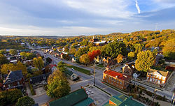
Early morning sun lights up the fall colors down Market Street in Hermann, Missouri
Flag of Hermann, Missouri.svg
Nickname: 
Deutschheim
Gasconade County Missouri Incorporated and Unincorporated areas Hermann Highlighted.svg
Location of Hermann, Missouri
Coordinates: 38°41′57″N91°26′21″W / 38.69917°N 91.43917°W / 38.69917; -91.43917
Country United States
State Missouri
County Gasconade
Established1837
Named for Hermann der Cherusker
Government
  TypeMayor/Alderman/Administrator
   Mayor Bruce Cox
  AdministratorPatricia Heaney
Area
[3]
  Total2.71 sq mi (7.01 km2)
  Land2.53 sq mi (6.54 km2)
  Water0.18 sq mi (0.47 km2)
Elevation
[4]
528 ft (161 m)
Population
 (2020)
  Total2,185
  Estimate 
(2023)
2,200
  Density864.66/sq mi (333.85/km2)
Time zone UTC-6 (Central (CST))
  Summer (DST) UTC-5 (CDT)
ZIP code
65041
Area code 573
FIPS code 29-31762 [5]
GNIS feature ID0719397 [4]
State highways MO-19.svg MO-100.svg
Waterways Missouri River
Website www.hermannmo.com
www.visithermann.com

Hermann is a city in and the county seat of Gasconade County, Missouri, United States. It has been the county seat since 1842. It is near the center of the Missouri Rhineland and south of the Missouri River. The population was 2,185 at the 2020 census. [6]

Contents

The city is the commercial center of the Hermann American Viticultural Area, whose seven wineries produce about one-third of the state's wine. Designated in 1983, it is one of the first federally recognized American Viticultural Areas. The designation recognized the renaissance of an area of vineyards and wineries established by German immigrants during the mid-19th century. Shut down by Prohibition, it began to revive in the 1960s.

Hermann holds a Maifest during the third weekend in May and an Oktoberfest the first four weekends in October. Hermann also calls itself the sausage-making capital of Missouri. [7]

Hermann High School holds the state record for the most girls high-school volleyball championships in Missouri.

History

Boat landing, showing boat unloading at elevator and freight house, circa 1920 Boat landing. Hermann, Missouri - NARA - 285926.tif
Boat landing, showing boat unloading at elevator and freight house, circa 1920
A bottle of Norton wine sits next to what is believed to be a 170-year-old Norton/Cynthiana grapevine cultivated by American wine legend George Husmann. The vines, which still produce grapes, are now part of OakGlenn Winery's vineyard. 120 Year Old Norton Cynthiana Grapevine.JPG
A bottle of Norton wine sits next to what is believed to be a 170-year-old Norton/Cynthiana grapevine cultivated by American wine legend George Husmann. The vines, which still produce grapes, are now part of OakGlenn Winery's vineyard.

The city was founded by the Deutsche Ansiedlungs-Gesellschaft zu Philadelphia (German Settlement Society of Philadelphia) in 1837. [8] It was promoted by Gottfried Duden, who wrote about the area in his Bericht über eine Reise nach den westlichen Staaten Nord Amerikas (Report of a Journey to the Western States of Northern America). In November 1837, an early group of settlers was led by George Bayer, who bought the land on the behalf of the society. George was waylaid in Pittsburgh, though, due to illness and arrived in Hermann in the spring of 1838 leading another group of families. The town was platted after the society sold shares in the 11,300 acres (4,600 ha) of Gasconade River valley land it had purchased.

The Hermannhof Winery Hermannhof Winery.jpg
The Hermannhof Winery

The society had almost utopian goals of a "heart of German America" where it could perpetuate traditional German culture and establish a self-supporting colony built around farming, commerce, and industry. The town is named after Hermann der Cherusker, a Germanic leader who defeated the Romans in the Battle of the Teutoburg Forest in 9 AD. In 2009, Hermann celebrated the 2000th anniversary of the battle, in which the Germanic warrior Hermann defeated three Roman legions.

    [9]

    A bronze statue of the city's namesake was dedicated in the Hermann Park. [10]

    Hermann was the nearest town to the Gasconade Bridge train disaster, November 1, 1855. The Leimer Hotel in Hermann [11] was used as a temporary hospital to treat the wounded. [12]

    In the 1960s, people began to rebuild the wine industry in the Hermann area. Today, the vineyards and wineries contribute to the agricultural and heritage tourism economies, with winery tours and wine tastings. Stone Hill Winery, the largest winemaking business in the state, and Hermannhof Winery are in the town; 2 miles (3.2 km) south of town off Missouri Highway 100 West is Adam Puchta Winery, the oldest continuously family-owned winery in the nation, under direct family ownership since 1855. [13] Bias Vineyards is less than 8 miles (13 km) east near Berger on Missouri Highway 100. Also included in the Hermann AVA are Oakglenn Vineyards and Winery, 2.5 miles (4.0 km) east of Hermann; Bommarito Estate Almond Tree Winery; and Röbbler Vineyards and Winery near New Haven.

    The Katy Trail, a 225-mile (362 km)-long bike path, passes through McKittrick, a town on the northern side of the Missouri River across from Hermann.

    The Hermann Historic District, Kotthoff-Weeks Farm Complex, Old Stone Hill Historic District, William Poeschel House, The Rotunda, and Vallet-Danuser House are listed on the National Register of Historic Places. [14]

    Demographics

    Historical population
    CensusPop.Note
    1850 943
    1860 1,10317.0%
    1870 1,33521.0%
    1880 1,314−1.6%
    1890 1,4107.3%
    1900 1,57511.7%
    1910 1,5921.1%
    1920 1,7016.8%
    1930 2,06321.3%
    1940 2,30811.9%
    1950 2,5239.3%
    1960 2,5360.5%
    1970 2,6584.8%
    1980 2,6951.4%
    1990 2,7542.2%
    2000 2,674−2.9%
    2010 2,431−9.1%
    2020 2,185−10.1%
    U.S. Decennial Census [15]

    2010 census

    As of the census [16] of 2010, 2,431 people, 1,047 households, and 614 families resided in the city. The population density was 960.9 inhabitants per square mile (371.0/km2). The 1,291 housing units had an average density of 510.3 per square mile (197.0/km2). The racial makeup of the city was 97.0% White, 0.6% African American, 0.1% Native American, 0.4% Asian, 0.5% from other races, and 1.4% from two or more races. Hispanics or Latinos of any race were 1.6% of the population.

    Of the 1,047 households, 25.8% had children under 18 living with them, 45.3% were married couples living together, 9.3% had a female householder with no husband present, 4.1% had a male householder with no wife present, and 41.4% were not families. About 37.2% of all households were made up of individuals, and 20.8% had someone living alone who was 65 or older. The average household size was 2.23, and the average family size was 2.93.

    The median age in the city was 44.9 years; 21.5% of residents were under 18; 6.8% were 18 to 24; 21.8% were 25 to 44; 25.4% were 45 to 64; and 24.4% were 65 or older. The gender makeup of the city was 47.4% male and 52.6% female.

    2000 census

    As of the census [5] of 2000, 2,674 people, 1,149 households, and 698 families were residing in the city. The population density was 1,161.5 inhabitants per square mile (448.5/km2). The 1,285 housing units had an average density of 558.2 per square mile (215.5/km2). The racial makeup of the city was 98.80% White, 0.22% African American, 0.07% Native American, 0.07% Asian, 0.30% from other races, and 0.52% from two or more races. Hispanics or Latinos of any race were 0.60% of the population.

    Of the 1,149 households, 27.6% had children under 18 living with them, 48.4% were married couples living together, 9.1% had a female householder with no husband present, and 39.2% were not families. Around 36.7% of all households were made up of individuals, and 22.5% had someone living alone who was 65 or older. The average household size was 2.20, and the average family size was 2.87.

    In the city, the age distribution was 22.4% under 18, 6.4% from 18 to 24, 23.4% from 25 to 44, 21.0% from 45 to 64, and 26.9% who were 65 or older. The median age was 43 years. For every 100 females, there were 83.5 males. For every 100 females 18 and over, there were 80.4 males.

    The median income for a household in the city was $35,634, and for a family was $44,621. Males had a median income of $27,426 versus $20,372 for females. The per capita income for the city was $19,428. About 5.0% of families and 6.7% of the population were below the poverty line, including 7.5% of those under age 18 and 6.9% of those age 65 or over.

    Education

    Public education in Hermann is administered by Gasconade County R-I School District, which operates one elementary school, one middle school, and Hermann High School. [17]

    Hermann has a lending library, a branch of the Scenic Regional Library system. [18]

    Notable people

    See also

    Related Research Articles

    <span class="mw-page-title-main">Warren County, Missouri</span> County in Missouri, United States

    Warren County is a county located in the eastern portion of the U.S. state of Missouri. As of the 2020 census, the population was 35,532. The county is located on the north side of the Missouri River. Its county seat is Warrenton. The county was established on January 5, 1833, and was named for General Joseph Warren, who died in the Battle of Bunker Hill during the American Revolutionary War.

    <span class="mw-page-title-main">Osage County, Missouri</span> County in Missouri, United States

    Osage County is a county in the central part of the U.S. state of Missouri. As of the 2020 census, the population was 13,274. Its county seat is Linn. The county was organized January 29, 1841, and named from the Osage River.

    <span class="mw-page-title-main">Gasconade County, Missouri</span> County in Missouri, United States

    Gasconade County is a county located in the east-central portion of the U.S. state of Missouri. As of the 2020 census, the population was 14,794. The county seat has been Hermann since 1842. The county was named after the Gasconade River.

    <span class="mw-page-title-main">Altus, Arkansas</span> City in Arkansas, United States

    Altus is a city in Franklin County, Arkansas, United States. Located within the Arkansas River Valley at the edge of the Ozark Mountains, the city is within the Fort Smith metropolitan area. The epicenter of the Altus American Viticultural Area (AVA) within Arkansas Wine Country, the city is home to four wineries. Although founded as a coal mining community, the wine industry has driven the Altus economy since the first vineyards were planted in 1872. The population was 758 at the 2010 census, down from 817 at the 2000 census.

    <span class="mw-page-title-main">Glen Ellen, California</span> Census designated place in California, United States

    Glen Ellen is a census-designated place (CDP) in Sonoma Valley, Sonoma County, California, United States. The population was 784 at the 2010 census, down from 992 at the 2000 census. Glen Ellen is the location of Jack London State Historic Park, Sonoma Valley Regional Park, and a former home of Hunter S. Thompson.

    <span class="mw-page-title-main">Washington, Missouri</span> City in Missouri, United States

    Washington is a city on the south banks of the Missouri River, 50 miles west of St. Louis, Missouri, and the largest in Franklin County, Missouri, United States. The estimated population in July 2021 was 14,916, an increase of 7% since the 2010 census. It is the corncob pipe capital of the world, with Missouri Meerschaum located on the riverfront.

    <span class="mw-page-title-main">Gasconade, Missouri</span> City in Missouri, United States

    Gasconade is a city in Gasconade County, Missouri. The population is 172 as of the 2020 census.

    <span class="mw-page-title-main">Morrison, Missouri</span> City in Missouri, United States

    Morrison is a city in Gasconade County, Missouri, United States. The first permanent settlement in the town was made by Robert Shobe circa 1828. The population was 93 at the 2020 census.

    <span class="mw-page-title-main">Owensville, Missouri</span> City in Missouri, United States

    Owensville is a city in Gasconade County, Missouri, United States. The population was 2,757 at the 2020 census.

    <span class="mw-page-title-main">Waverly, Missouri</span> City in Missouri, United States

    Waverly is a city in Lafayette County, Missouri, and part of the Kansas City metropolitan area within the United States. The population was 849 at the 2010 census.

    <span class="mw-page-title-main">New Florence, Missouri</span> City in Missouri, United States

    New Florence is a city in Montgomery County, Missouri, United States. The population was 641 at the 2020 census.

    <span class="mw-page-title-main">Linn, Missouri</span> City in Missouri, United States

    Linn is a city in Osage County, Missouri, United States. The population was 1,350 at the 2020 census. It is the county seat of Osage County. Linn is part of the Jefferson City, Missouri Metropolitan Statistical Area.

    <span class="mw-page-title-main">Westphalia, Missouri</span> City in Missouri, United States

    Westphalia is a city in Osage County, Missouri, United States. The population was 378 at the 2020 census. It is part of the Jefferson City, Missouri Metropolitan Statistical Area.

    <span class="mw-page-title-main">Crocker, Missouri</span> City in Missouri, United States

    Crocker is a city in Pulaski County, Missouri, United States. The population was 1,110 at the 2010 census.

    <span class="mw-page-title-main">Dixon, Missouri</span> City in Missouri, United States

    Dixon is a city in northern Pulaski County, Missouri, United States, with a population of 1,549 at the time of the 2010 census.

    <span class="mw-page-title-main">Augusta, Missouri</span> City in Missouri, United States

    Augusta is a city in St. Charles County, Missouri, United States. The population was 270 at the 2020 census, up from 253 at the 2010 census. The city has wineries, antique shops, restaurants, B&B's, a wood shop, a glass studio, massage therapy, a historic museum, and The Augusta Brewery.

    <span class="mw-page-title-main">Seymour, Missouri</span> City in Missouri, United States

    Seymour is a city in southeastern Webster County, Missouri, United States. The population was 1,921 at the 2010 census. It is part of the Springfield, Missouri Metropolitan Statistical Area.

    <span class="mw-page-title-main">Hartville, Missouri</span> City in Missouri, United States

    Hartville is a city in Wright County, Missouri, United States. The population was 594 at the 2020 census. It is the county seat of Wright County.

    <span class="mw-page-title-main">Marthasville, Missouri</span> City in Missouri, United States

    Marthasville is a city in Warren County, Missouri, United States. The population was 1,136 at the 2010 census. The Katy Trail, a 225-mile long bike path, passes through Marthasville.

    <span class="mw-page-title-main">Dobson, North Carolina</span> Town in North Carolina, United States

    Dobson is a town in Dobson Township, Surry County, North Carolina, United States. As of the 2020 census, the town population was 1,396. It is the county seat of Surry County. Dobson is the home of the Shelton Vineyards, the largest winery in North Carolina. It is also home to a significant Latino population due to the large number of farms in the area. The main crops in the area are corn, tobacco and soy beans.

    References

    1. Hermann City Government
    2. City Government Officials - City of Hermann, Missouri Archived 2014-12-05 at the Wayback Machine
    3. "ArcGIS REST Services Directory". United States Census Bureau. Retrieved August 28, 2022.
    4. 1 2 U.S. Geological Survey Geographic Names Information System: Hermann, Missouri
    5. 1 2 "U.S. Census website". United States Census Bureau . Retrieved January 31, 2008.
    6. "Explore Census Data". data.census.gov. Retrieved January 24, 2022.
    7. Official Wurstfest page Archived 2008-05-14 at the Wayback Machine
    8. Eaton, David Wolfe (1916). How Missouri Counties, Towns and Streams Were Named. The State Historical Society of Missouri. pp.  169.
    9. MacGregor, Neil (2014). Germany. BBC. p. 128.
    10. "Partnerstadt Hermann grüßt Bad Arolsen mit Arminius aus Bronze". Waldeckische Landeszeitung Frankenberger Zeitung. December 22, 2009. Retrieved May 22, 2011.
    11. "First Train – First Disaster".
    12. "Little Germany on the Missouri," by Anna Kemper Hesse, University of Missouri Press, 1998, p. 43
    13. Adam Puchta Winery, accessed 20 Jun 2008
    14. "National Register Information System". National Register of Historic Places . National Park Service. July 9, 2010.
    15. "Census of Population and Housing". Census.gov. Retrieved June 4, 2015.
    16. "U.S. Census website". United States Census Bureau . Retrieved July 8, 2012.
    17. "Gasconade County R-I School District". Great Schools. Retrieved June 2, 2019.
    18. "Locations and Hours". Scenic Regional Library. Retrieved June 2, 2019.

    Further reading