Rosebud, Missouri

Last updated

Rosebud, Missouri
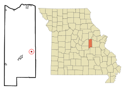
Gasconade County Missouri Incorporated and Unincorporated areas Rosebud Highlighted.svg
Location of Rosebud, Missouri
Coordinates: 38°23′06″N91°24′09″W / 38.38500°N 91.40250°W / 38.38500; -91.40250
Country United States
State Missouri
County Gasconade
Government
  TypeMayor / Council
  MayorShannon Grus
Area
[1]
  Total0.88 sq mi (2.26 km2)
  Land0.87 sq mi (2.26 km2)
  Water0.00 sq mi (0.01 km2)
Elevation
[2]
869 ft (265 m)
Population
 (2020)
  Total390
  Density447.76/sq mi (172.94/km2)
Time zone UTC-6 (Central (CST))
  Summer (DST) UTC-5 (CDT)
ZIP code
63091
Area code 573
FIPS code 29-63110 [3]
GNIS feature ID2396431 [2]

Rosebud is a city in Gasconade County, Missouri, United States. The population was 390 at the 2020 census. [4]

Contents

Geography

According to the United States Census Bureau, the city has a total area of 0.87 square miles (2.25 km2), all land. [5]

Climate

According to the Köppen Climate Classification system, Rosebud has a humid subtropical climate, abbreviated "Cfa" on climate maps. The hottest temperature recorded in Rosebud was 107 °F (41.7 °C) on August 30, 1984, while the coldest temperature recorded was −26 °F (−32.2 °C) on January 7, 2014. [6]

Climate data for Rosebud, Missouri, 1991–2020 normals, extremes 1980–present
MonthJanFebMarAprMayJunJulAugSepOctNovDecYear
Record high °F (°C)74
(23)
82
(28)
91
(33)
94
(34)
96
(36)
106
(41)
105
(41)
107
(42)
101
(38)
93
(34)
84
(29)
77
(25)
107
(42)
Mean maximum °F (°C)65.2
(18.4)
70.5
(21.4)
78.0
(25.6)
84.3
(29.1)
87.0
(30.6)
91.7
(33.2)
96.5
(35.8)
96.9
(36.1)
91.5
(33.1)
85.1
(29.5)
76.0
(24.4)
66.5
(19.2)
96.9
(36.1)
Mean daily maximum °F (°C)39.8
(4.3)
45.0
(7.2)
55.0
(12.8)
66.3
(19.1)
74.6
(23.7)
82.8
(28.2)
87.4
(30.8)
86.6
(30.3)
79.3
(26.3)
68.1
(20.1)
55.0
(12.8)
43.9
(6.6)
65.3
(18.5)
Daily mean °F (°C)28.9
(−1.7)
33.0
(0.6)
42.4
(5.8)
52.9
(11.6)
62.4
(16.9)
71.1
(21.7)
75.5
(24.2)
73.9
(23.3)
65.8
(18.8)
54.5
(12.5)
42.7
(5.9)
33.1
(0.6)
53.0
(11.7)
Mean daily minimum °F (°C)18.0
(−7.8)
21.1
(−6.1)
29.9
(−1.2)
39.6
(4.2)
50.2
(10.1)
59.5
(15.3)
63.5
(17.5)
61.3
(16.3)
52.3
(11.3)
41.0
(5.0)
30.5
(−0.8)
22.3
(−5.4)
40.8
(4.9)
Mean minimum °F (°C)−2.2
(−19.0)
3.1
(−16.1)
11.8
(−11.2)
25.8
(−3.4)
34.6
(1.4)
47.6
(8.7)
53.9
(12.2)
51.0
(10.6)
37.3
(2.9)
25.9
(−3.4)
15.8
(−9.0)
4.8
(−15.1)
−5.4
(−20.8)
Record low °F (°C)−26
(−32)
−16
(−27)
−4
(−20)
17
(−8)
20
(−7)
40
(4)
48
(9)
36
(2)
27
(−3)
17
(−8)
1
(−17)
−23
(−31)
−26
(−32)
Average precipitation inches (mm)2.69
(68)
2.40
(61)
3.67
(93)
4.84
(123)
5.58
(142)
4.48
(114)
3.94
(100)
3.94
(100)
4.01
(102)
3.37
(86)
3.58
(91)
2.69
(68)
45.19
(1,148)
Average snowfall inches (cm)4.2
(11)
3.5
(8.9)
1.7
(4.3)
0.0
(0.0)
0.0
(0.0)
0.0
(0.0)
0.0
(0.0)
0.0
(0.0)
0.0
(0.0)
0.0
(0.0)
1.5
(3.8)
3.3
(8.4)
14.2
(36.4)
Average extreme snow depth inches (cm)3.8
(9.7)
2.8
(7.1)
2.5
(6.4)
0.0
(0.0)
0.0
(0.0)
0.0
(0.0)
0.0
(0.0)
0.0
(0.0)
0.0
(0.0)
0.0
(0.0)
0.7
(1.8)
3.6
(9.1)
5.0
(13)
Average precipitation days (≥ 0.01 in)8.18.311.211.512.710.78.88.28.08.88.58.8113.6
Average snowy days (≥ 0.1 in)3.42.61.00.00.00.00.00.00.00.00.82.610.4
Source 1: NOAA [7]
Source 2: National Weather Service [6]

Demographics

Historical population
CensusPop.Note
1930 162
1940 19319.1%
1950 25431.6%
1960 28813.4%
1970 3055.9%
1980 3266.9%
1990 38016.6%
2000 364−4.2%
2010 40912.4%
2020 390−4.6%
U.S. Decennial Census [8]

2010 census

As of the census [9] of 2010, there were 409 people, 179 households, and 107 families living in the city. The population density was 470.1 inhabitants per square mile (181.5/km2). There were 197 housing units at an average density of 226.4 per square mile (87.4/km2). The racial makeup of the city was 97.1% White, 0.2% Native American, 1.0% Asian, 0.2% Pacific Islander, 0.5% from other races, and 1.0% from two or more races. Hispanic or Latino of any race were 1.7% of the population.

There were 179 households 26.8% had children under the age of 18 living with them, 47.5% were married couples living together, 10.1% had a female householder with no husband present, 2.2% had a male householder with no wife present, and 40.2% were non-families. 34.1% of all households were made up of individuals, and 15.1% had someone living alone who was 65 years of age or older. The average household size was 2.28 and the average family size was 2.88.

The median age in the city was 43.2 years. 22.7% of residents were under the age of 18; 5.9% were between the ages of 18 and 24; 24.7% were from 25 to 44; 27.4% were from 45 to 64; and 19.3% were 65 years of age or older. The gender makeup of the city was 47.4% male and 52.6% female.

2000 census

As of the census [3] of 2000, there were 364 people, 155 households, and 103 families living in the city. The population density was 1,119.4 inhabitants per square mile (432.2/km2). There were 165 housing units at an average density of 507.4 per square mile (195.9/km2). The racial makeup of the city was 97.53% White, 0.27% African American, and 2.20% from two or more races.

There were 155 households, out of which 31.6% had children under the age of 18 living with them, 55.5% were married couples living together, 8.4% had a female householder with no husband present, and 33.5% were non-families. 32.3% of all households were made up of individuals, and 17.4% had someone living alone who was 65 years of age or older. The average household size was 2.35 and the average family size was 2.88.

In the city the population was spread out, with 25.8% under the age of 18, 9.6% from 18 to 24, 27.7% from 25 to 44, 17.9% from 45 to 64, and 19.0% who were 65 years of age or older. The median age was 36 years. For every 100 females, there were 91.6 males. For every 100 females age 18 and over, there were 90.1 males.

The median income for a household in the city was $29,688, and the median income for a family was $33,750. Males had a median income of $24,766 versus $17,857 for females. The per capita income for the city was $18,513. About 13.5% of families and 23.3% of the population were below the poverty line, including 30.2% of those under age 18 and 16.4% of those age 65 or over.
Related Research Articles

<span class="mw-page-title-main">Gove City, Kansas</span> City in Gove County, Kansas

Gove City, more commonly known as Gove, is a city in and the county seat of Gove County, Kansas, United States. As of the 2020 census, the population of the city was 80.

<span class="mw-page-title-main">Kingman, Kansas</span> City in Kingman County, Kansas

Kingman is a city in and the county seat of Kingman County, Kansas, United States. As of the 2020 census, the population of the city was 3,105.

<span class="mw-page-title-main">Meade, Kansas</span> City in Meade County, Kansas

Meade is a city in and the county seat of Meade County, Kansas, United States. As of the 2020 census, the population of the city was 1,505.

<span class="mw-page-title-main">Lyndon, Kansas</span> City in Osage County, Kansas

Lyndon is a city in, and the county seat of Osage County, Kansas, United States. As of the 2020 census, the population of the city was 1,037.

<span class="mw-page-title-main">Ottertail, Minnesota</span> City in Minnesota, United States

Ottertail is a city in Otter Tail County, Minnesota, United States. The population was 629 at the 2020 census.

Rosebud Township is a township in Polk County, Minnesota, United States. It is part of the Grand Forks-ND-MN Metropolitan Statistical Area. The population was 343 at the 2000 census.

<span class="mw-page-title-main">Busby, Montana</span> Census-designated place in Big Horn County, Montana, United States

Busby is a census-designated place (CDP) in Big Horn County, Montana, United States. It is on the Northern Cheyenne reservation. The population was 745 at the 2010 census.

<span class="mw-page-title-main">Birney, Montana</span> Census-designated place in Montana, United States

Birney is a census-designated place (CDP) in Rosebud County, Montana, United States. The population was 108 at the 2000 census.

<span class="mw-page-title-main">Forsyth, Montana</span> City in Montana, United States

Forsyth is a city in and the county seat of Rosebud County, Montana, United States. The population was 1,647 at the 2020 census. Forsyth was established in 1876 as the first settlement on the Yellowstone River, and in 1882 residents named the town after General James William Forsyth who commanded Fort Maginnis, Montana during the Indian Wars and the 7th Cavalry at the Wounded Knee Massacre. The town has long been a transportation nexus, starting with steamboats on the river and progressing to the Northern Pacific Railway and Interstate 94.

<span class="mw-page-title-main">Rogers, North Dakota</span> City in North Dakota, United States

Rogers is a city in Barnes County, North Dakota, United States. The population was 49 at the 2020 census. Rogers was founded in 1897.

<span class="mw-page-title-main">Warwick, North Dakota</span> City in North Dakota, United States

Warwick is a city in Benson County, North Dakota, United States. The population was 55 at the 2020 census. Warwick was founded in 1907.

<span class="mw-page-title-main">Lansford, North Dakota</span> City in North Dakota, United States

Lansford is a city in Bottineau County, North Dakota, United States. The population was 238 at the 2020 census. Lansford was founded in 1903.

<span class="mw-page-title-main">Kenmare, North Dakota</span> City in North Dakota, United States

Kenmare is a city in Ward County, North Dakota, United States. The population was 961 at the 2020 census. Kenmare is part of the Minot Micropolitan Statistical Area.

<span class="mw-page-title-main">Unity, Oregon</span> City in Oregon, United States

Unity is a city in Baker County, Oregon, United States, located in the Burnt River Valley. The population was 71 at the 2010 census.

<span class="mw-page-title-main">Wagner, South Dakota</span> City in South Dakota, United States

Wagner is a city in Charles Mix County, South Dakota, United States. The population was 1,490 at the 2020 census. The city is served by Wagner Municipal Airport as well as YST Transit buses.

<span class="mw-page-title-main">Parkston, South Dakota</span> City in South Dakota, United States

Parkston is a city in Hutchinson County, South Dakota, United States. The population was 1,567 at the 2020 census.

<span class="mw-page-title-main">Mission, South Dakota</span> City in South Dakota, United States

Mission is a city on the Rosebud Indian Reservation in northern Todd County, South Dakota, United States. The population was 1,156 at the 2020 census.

<span class="mw-page-title-main">Rosebud, South Dakota</span> CDP in South Dakota, United States

Rosebud also Sicanġu is a census-designated place (CDP) in Todd County, South Dakota, United States. The population was 1,455 at the 2020 census.

<span class="mw-page-title-main">Rosebud, Texas</span> City in Texas

Rosebud is a city in Falls County, Texas, United States. Its population was 1,296 at the 2020 census.

<span class="mw-page-title-main">Hambleton, West Virginia</span> Town in West Virginia, United States

Hambleton is a town in Tucker County, West Virginia, United States. The population was 216 at the 2020 census. Hambleton was established in 1889, but not incorporated until 1905. It was named by then United States Senator Stephen B. Elkins in honor of a stockholder by this name in the West Virginia Central Railroad Company. The town was previously known as Hulings.

References

  1. "ArcGIS REST Services Directory". United States Census Bureau. Retrieved August 28, 2022.
  2. 1 2 U.S. Geological Survey Geographic Names Information System: Rosebud, Missouri
  3. 1 2 "U.S. Census website". United States Census Bureau . Retrieved January 31, 2008.
  4. "Explore Census Data". data.census.gov. Retrieved January 24, 2022.
  5. "US Gazetteer files 2010". United States Census Bureau. Archived from the original on January 25, 2012. Retrieved July 8, 2012.
  6. 1 2 "NOAA Online Weather Data – NWS St. Louis". National Weather Service. Retrieved November 26, 2022.
  7. "U.S. Climate Normals Quick Access – Station: Rosebud, MO". National Oceanic and Atmospheric Administration. Retrieved November 26, 2022.
  8. "Census of Population and Housing". Census.gov. Retrieved June 4, 2015.
  9. "U.S. Census website". United States Census Bureau . Retrieved July 8, 2012.