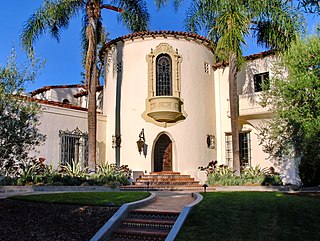
Los Feliz is a hillside neighborhood in the greater Hollywood area of Los Angeles, California, abutting Hollywood and encompassing part of the Santa Monica Mountains. The neighborhood is named after the Feliz family of Californios who had owned the area since 1795, when José Vicente Féliz was granted Rancho Los Feliz.

Hollywood Boulevard is a major east–west street in Los Angeles, California. It runs through the Hollywood, East Hollywood, Little Armenia, Thai Town, and Los Feliz districts. Its western terminus is at Sunset Plaza Drive in the Hollywood Hills and its eastern terminus is at Sunset Boulevard in Los Feliz. Hollywood Boulevard is famous for running through the tourist areas in central Hollywood, including attractions such as the Hollywood Walk of Fame and the Ovation Hollywood shopping and entertainment complex.

Colorado Boulevard is a major east–west street in Southern California. It runs from Griffith Park in Los Angeles east through Glendale, the Eagle Rock section of Los Angeles, Pasadena, and Arcadia, ending in Monrovia. The full route was once various state highways but is now locally maintained in favor of the parallel Ventura Freeway and Foothill Freeway (I-210).

Crenshaw Boulevard is a north-south thoroughfare in Los Angeles, California, United States, that runs through Crenshaw and other neighborhoods along a 23-mile route in the west-central part of the city.

East Hollywood is a densely populated neighborhood of 78,000+ residents that is part of the Hollywood area of the central region of Los Angeles, California. It is notable for being the site of Los Angeles City College, Barnsdall Park, and a hospital district. There are seven public and five private schools, a Los Angeles Public Library branch, and three hospitals. Almost two-thirds of the people living there were born outside the United States, and 90% were renters. In 2000, the neighborhood had high percentages of never-married people and single parents.

Beverly Boulevard is one of the main east–west thoroughfares in Los Angeles, in the U.S. state of California. It begins off Santa Monica Boulevard in Beverly Hills and ends on the Lucas Avenue overpass near downtown Los Angeles to become 1st Street. A separate Beverly Boulevard begins off 3rd Street and Pomona Boulevard in East Los Angeles, runs through Montebello and Pico Rivera, and becomes Turnbull Canyon Road in Whittier near Rose Hills Memorial Park.

Western Avenue is a major four-lane street in the city of Los Angeles and through the center portion of Los Angeles County, California. It is one of the longest north–south streets in Los Angeles city and county, apart from Sepulveda Boulevard. It is about 29 miles (47 km) long.

Centinela Avenue is a 10.2 mile major street in the Westside region of Los Angeles County, California.

Vermont Avenue is one of the longest running north–south streets in City of Los Angeles and Los Angeles County, California. With a length of 23.3 miles (37.5 km), is the third longest of the north–south thoroughfares in the region. For most of its length between its southern end in San Pedro and south of Downtown Los Angeles, it runs parallel to the west of the Harbor Freeway (I-110).

San Fernando Road is a major street in the City of Los Angeles and Los Angeles County. Within the Burbank city limits it is signed as San Fernando Boulevard, and north of Newhall Pass it is signed as The Old Road. It was previously designated as Business Loop 5 in the 1970s.
Victory Boulevard is a major east–west arterial road that runs for 25 miles (40 km) traversing the entire length of the San Fernando Valley in Los Angeles County, California.

Riverside Drive is a northeast–southwest road connecting the San Fernando Valley and the Cypress Park neighborhood of the City of Los Angeles. It follows the course of the Los Angeles River.

Normandie Avenue is one of Los Angeles County's longest north–south streets, with a stretch of about 22.5 miles (36.2 km). It lies between Western Avenue to the west and Vermont Avenue to the east. The avenue begins in the south by branching off from Vermont Avenue south of Pacific Coast Highway in Harbor City. Through traffic on Normandie is directed onto Irolo Street between just north of Olympic Boulevard and Wilshire Boulevard; in this section, Normandie exists as a small residential street. After crossing Franklin Avenue, Normandie resumes as a residential street before reaching its northern terminus at Ambrose Avenue in the Los Feliz district of Los Angeles.
Glendale Boulevard is a north–south street in Los Angeles. It starts off as Lucas Avenue at 7th Street west of Downtown Los Angeles, California.

Glendale–Burbank is a defunct Pacific Electric railway line that was operational from 1904 to 1955 in Southern California, running from Downtown Los Angeles to Burbank via Glendale. Short lines terminated Downtown and in North Glendale, including the popular Edendale Local.
This article covers streets in Los Angeles, California between and including 41st Street and 250th Street. Major streets have their own linked articles; minor streets are discussed here.
Los Angeles's 14th City Council district is one of the fifteen districts in the Los Angeles City Council. The district, which has a large Latin American population, includes the neighborhoods of Boyle Heights, Downtown Los Angeles and parts of Northeast Los Angeles. It is currently represented by Democrat Kevin de León since 2020. He replaced José Huizar after winning outright in the special election held during the 2020 California primaries; he was officially appointed on October 15, 2020. Huizar had vacated the seat earlier in the year due to bribery and corruption allegations.

Los Angeles's 2nd City Council district is one of the fifteen districts in the Los Angeles City Council. It is currently represented by Democrat Paul Krekorian since 2009, after he won the special election to finish Wendy Greuel's term.

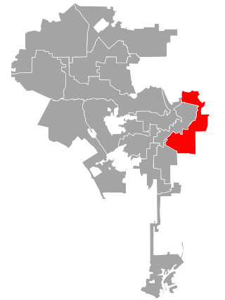
Los Angeles's 4th City Council district is one of the fifteen districts in the Los Angeles City Council. It is currently represented by Democrat Nithya Raman since 2020 after she defeated David Ryu in that year's election. The district is situated in Central Los Angeles, the southern San Fernando Valley, and eastern Santa Monica Mountains.

The Los Angeles River bicycle path is a Class I bicycle and pedestrian path in the Greater Los Angeles area running from north to east along the Los Angeles River through Griffith Park in an area known as the Glendale Narrows. The 7.4 mile section of bikeway through the Glendale Narrows is known as the Elysian Valley Bicycle & Pedestrian Path. The bike path also runs from the city of Vernon to Long Beach, California. This section is referred to as LARIO, or more formally, the Los Angeles River Bikeway.

