
Los Angeles, often referred to by its initials L.A., is the commercial, financial, and cultural center of Southern California. Los Angeles is the largest city in the state of California, the second most populous city in the United States after New York City, and one of the world's most populous megacities. With a population of roughly 3.9 million residents within the city limits as of 2020, Los Angeles is known for its Mediterranean climate, ethnic and cultural diversity, being the home of the Hollywood film industry, and its sprawling metropolitan area. The majority of the city proper lies in a basin in Southern California adjacent to the Pacific Ocean in the west and extending partly through the Santa Monica Mountains and north into the San Fernando Valley, with the city bordering the San Gabriel Valley to its east. It covers about 469 square miles (1,210 km2), and is the county seat of Los Angeles County, which is the most populous county in the United States with an estimated 9.86 million residents as of 2022.

The Los Angeles Community College District (LACCD) is the community college district serving Los Angeles, California, and some of its neighboring cities and certain unincorporated areas of Los Angeles County. Its headquarters are in Downtown Los Angeles. Over the past seventy-seven years LACCD has served as educator to more than three million students. In addition to typical college aged students, the LACCD also serves adults of all ages: over half of all LACCD students are older than 25 years of age, and more than a quarter are 35 or older. LACCD educates almost three times as many Latino students and nearly four times as many African-American students as all of the University of California campuses combined. Eighty percent of LACCD students are from underserved populations. The Los Angeles Community College District is the largest community college district in the United States and is one of the largest in the world. The nine colleges within the district offer educational opportunities to students in Los Angeles. It serves students located in the Alhambra, Beverly Hills, Burbank, Culver City, Garvey, Las Virgenes, Los Angeles, Montebello, Palos Verdes and San Gabriel school districts. The district covers the Los Angeles city limits, San Fernando, Calabasas, Agoura Hills, Hidden Hills, Burbank, West Hollywood, Beverly Hills, Culver City, Alhambra, Monterey Park, San Gabriel, Rosemead, Montebello, Commerce, Vernon, Huntington Park, Bell, Cudahy, Bell Gardens, South Gate, Gardena, Carson, Lomita, Palos Verdes Estates, Rolling Hills, Rancho Palos Verdes, and numerous unincorporated communities, including East Los Angeles, Florence-Firestone, Athens, and Walnut Park. The LACCD consists of nine colleges and covers an area of more than 882 square miles (2,280 km2).

Orange County, often known by its initials O.C., is located in the Los Angeles metropolitan area in Southern California. As of the 2020 census, the population was 3,186,989, making it the third-most-populous county in California, the sixth-most-populous in the United States, and more populous than 19 American states and Washington, D.C. Although largely suburban, it is the second-most-densely-populated county in the state behind San Francisco County. The county's three most-populous cities are Anaheim, Santa Ana, and Irvine, each of which has a population exceeding 300,000. Santa Ana is also the county seat. Six cities in Orange County are on the Pacific coast: Seal Beach, Huntington Beach, Newport Beach, Laguna Beach, Dana Point, and San Clemente.

Southern California is a geographic and cultural region that generally comprises the southern portion of the U.S. state of California. It includes the Los Angeles metropolitan area, the second most populous urban agglomeration in the United States. The region generally contains ten of California's 58 counties: Imperial, Kern, Los Angeles, Orange, Riverside, San Bernardino, San Diego, Santa Barbara, San Luis Obispo and Ventura counties.
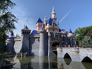
Anaheim is a city in northern Orange County, California, part of the Los Angeles metropolitan area. As of the 2020 United States Census, the city had a population of 346,824, making it the most populous city in Orange County, the 10th-most populous city in California, and the 55th-most populous city in the United States. Anaheim is the second-largest city in Orange County in terms of land area, and is known for being the home of the Disneyland Resort, the Anaheim Convention Center, and two major sports teams: the Los Angeles Angels baseball team and the Anaheim Ducks ice hockey club.

Glendale is a city in the San Fernando Valley and Verdugo Mountains regions of Los Angeles County, California, United States. At the 2020 U.S. Census the population was 196,543, up from 191,719 at the 2010 census, making it the fourth-largest city in Los Angeles County and the 24th-largest city in California. It is located about 10 miles (16 km) north of downtown Los Angeles.

Greater Los Angeles is the second-largest metropolitan area in the United States, with a population of 18.5 million in 2021, encompassing five counties in Southern California extending from Ventura County in the west to San Bernardino County and Riverside County in the east, with Los Angeles County in the center and Orange County to the southeast. According to the U.S. Census Bureau, the Los Angeles–Anaheim–Riverside combined statistical area covers 33,954 square miles (87,940 km2), making it the largest metropolitan region in the United States by land area. Of this, the contiguous urban area is 2,281 square miles (5,910 km2), the remainder mostly consisting of mountain and desert areas. In addition to being the nexus of the global entertainment industry, Greater Los Angeles is also an important center of international trade, education, media, business, tourism, technology, and sports. It is the 3rd largest metropolitan area by nominal GDP in the world with an economy exceeding $1 trillion in output.
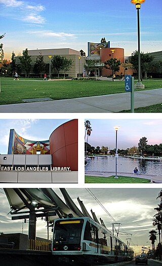
East Los Angeles, or East L.A., often referred to by locals as "East Los", is an unincorporated area in Los Angeles County, California, United States. For statistical purposes, the United States Census Bureau regards East Los Angeles as a census-designated place (CDP). As of the 2020 census it had a population of 118,786, a drop of 6.1% from 2010, when the population was 126,496.
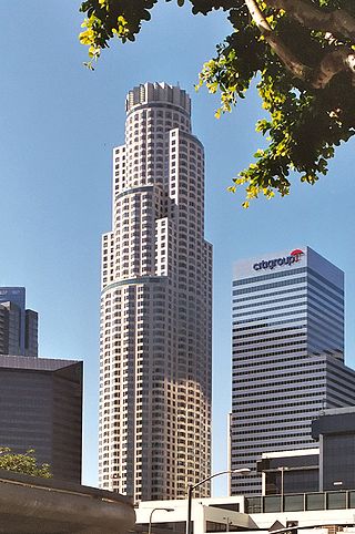
U.S. Bank Tower, known locally as the Library Tower and formerly as the First Interstate Bank World Center, is a 1,018-foot (310.3 m) skyscraper in downtown Los Angeles, California. It is, by structural height, the third-tallest building in California, the second-tallest building in Los Angeles, the 24th-tallest in the United States, the third-tallest west of the Mississippi River after the Salesforce Tower and the Wilshire Grand Center, and the 129th-tallest building in the world, after being surpassed by the Wilshire Grand Center. However, the U.S. Bank Tower does surpass both the Salesforce Tower and the Wilshire Grand Center in roof height, making it the only building in California whose roof height exceeds 1,000 feet (300 m). Because local building codes required all high-rise buildings to have a helipad, it was known as the tallest building in the world with a rooftop heliport from its completion in 1989 to 2010 when the China World Trade Center Tower III opened. It is also the third-tallest building in a major active seismic region; its structure was designed to resist an earthquake of 8.3 on the Richter scale. It consists of 73 stories above ground and two parking levels below ground. Construction began in 1987 with completion in 1989. The building was designed by Henry N. Cobb of the architectural firm Pei Cobb Freed & Partners and cost $350 million to build. It is one of the most recognizable buildings in Los Angeles, and often appears in establishing shots for the city in films and television programs.

Downtown Los Angeles (DTLA) contains the central business district of Los Angeles. In addition, it contains a diverse residential area of some 85,000 people, and covers 5.84 sq mi (15.1 km2). A 2013 study found that the district is home to over 500,000 jobs. It is also part of Central Los Angeles.

The Third Street Promenade is a pedestrian mall esplanade, shopping, dining and entertainment complex in the downtown area of Santa Monica, California which originally opened as the Santa Monica Mall on November 8, 1965. It is considered a premier shopping and dining district on the Westside and draws crowds from all over the Greater Los Angeles area. Due to easy access to Downtown Los Angeles via the Big Blue Bus rapid transit service, E Line's terminus station and the Pacific Coast Highway-Santa Monica Freeway Interstate, the neighborhood's north-south thoroughfares connecting to Muscle Beach, Venice Canal Historic District, Marina del Rey, Ballona Wetlands and Los Angeles International Airport, and its proximity to historic U.S. Route 66, Santa Monica Pier, Palisades Park, Tongva Park, Santa Monica State Beach and the Pacific Ocean coupled with Los Angeles's mild mediterranean climate, it is also a popular tourist destination.

Kenneth Hahn State Recreation Area, or Kenneth Hahn Park, is a state park unit of California in the Baldwin Hills Mountains of Los Angeles. The park is managed by the Los Angeles County Department of Parks and Recreation. As one of the largest urban parks and regional open spaces in the Greater Los Angeles Area, many have called it "L.A.'s Central Park". The 401-acre (1.62 km2) park was established in 1984.

Los Angeles Nurses' Club is a clubhouse and apartment building for nurses located in the Westlake district of Central Los Angeles, California.

South Los Angeles, also known as South Central Los Angeles or simply South Central, is a region in southwestern Los Angeles County, lying mostly within the city limits of Los Angeles, south of downtown. It is "defined on Los Angeles city maps as a 16-square-mile rectangle with two prongs at the south end.” In 2003, the Los Angeles City Council renamed this area "South Los Angeles".

Downtown Inglewood station is an at-grade light rail station on the K Line of the Los Angeles Metro Rail system. It is located alongside Florence Avenue between Market and Locust Streets in the central business district of the city of Inglewood, California.

Grand Hope Park is a 2.5-acre (1.0 ha) urban park in the South Park District of Downtown Los Angeles, California.

Richard J. Riordan Central Library, also known as the Los Angeles Central Library, is the main branch of the Los Angeles Public Library (LAPL), in Downtown Los Angeles. It is named after Mayor of Los Angeles Richard Riordan.

