
The Los Angeles River, historically known as Paayme Paxaayt'West River' by the Tongva and the Río Porciúncula'Porciúncula River' by the Spanish, is a major river in Los Angeles County, California. Its headwaters are in the Simi Hills and Santa Susana Mountains, and it flows nearly 51 miles (82 km) from Canoga Park through the San Fernando Valley, downtown Los Angeles, and the Gateway Cities to its mouth in Long Beach, where it flows into San Pedro Bay. While the river was once free-flowing and frequently flooding, forming alluvial flood plains along its banks, it currently flows through a concrete channel on a fixed course, which was built after a series of devastating floods in the early 20th century.

The Pacific Electric Railway Company, nicknamed the Red Cars, was a privately owned mass transit system in Southern California consisting of electrically powered streetcars, interurban cars, and buses and was the largest electric railway system in the world in the 1920s. Organized around the city centers of Los Angeles and San Bernardino, it connected cities in Los Angeles County, Orange County, San Bernardino County and Riverside County.

The Arroyo Seco Parkway, also known as the Pasadena Freeway, is one of the oldest freeways in the United States. It connects Los Angeles with Pasadena alongside the Arroyo Seco seasonal river. Mostly opened in 1940, it represents the transitional phase between early parkways and later freeways. It conformed to modern standards when it was built, but is now regarded as a narrow, outdated roadway. A 1953 extension brought the south end to the Four Level Interchange in downtown Los Angeles and a connection with the rest of the freeway system.

Atwater Village is a neighborhood in the 13th district of Los Angeles, California. Much of Atwater Village lies in the fertile Los Angeles River flood plain. Located in the northeast region of the city, Atwater borders Griffith Park and Silver Lake to the west, Glendale to the north and east and Glassell Park to the south. The eastern boundary is essentially the railroad tracks. The area has three elementary schools—two public and one private. Almost half the residents were born abroad, a high percentage for the city of Los Angeles.

Downtown Disney is a lifestyle center located at the Disneyland Resort in Anaheim, California, United States. It opened on January 12, 2001; a component of the Disneyland Resort expansion project alongside the Disney California Adventure theme park and Disney's Grand Californian Hotel & Spa.
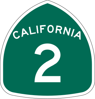
State Route 2 (SR 2) is a state highway in the U.S. state of California. It connects the Los Angeles Basin with the San Gabriel Mountains and the Victor Valley in the Mojave Desert. The highway's southwestern end is at the intersection of Centinela Avenue at the Santa Monica-Los Angeles border and its northeastern end is at SR 138 east of Wrightwood. The SR 2 is divided into four segments, and it briefly runs concurrently with U.S. Route 101 (US 101) and Interstate 210 (I-210). The southwestern section of SR 2 runs along a segment of the east–west Santa Monica Boulevard, an old routing of US 66, to US 101 in East Hollywood; the second section runs along segments of both the north–south Alvarado Street and Glendale Boulevard in Echo Park; the third section to I-210 in Glendale is known as the north–south Glendale Freeway; and the northeastern portion from I-210 in La Cañada Flintridge to SR 138 is designated as the Angeles Crest Highway.

The Disneyland Monorail is an attraction and transportation line at the Disneyland Resort in Anaheim, California, United States. It was the first daily operating monorail in the world.

The Pyrmont Bridge, a heritage-listed swing bridge across Cockle Bay, is located in Darling Harbour, part of Port Jackson, west of the central business district in the City of Sydney local government area of New South Wales, Australia. Opened in 1902, the bridge initially carried motor vehicle traffic via the Pyrmont Bridge Road between the central business district and Pyrmont. Since 1981 the bridge has carried pedestrian and bicycle traffic only, as motor vehicles were diverted to adjacent freeway overpasses. The bridge was added to the New South Wales State Heritage Register on 28 June 2002, the centenary of its opening.

The Arroyo Seco, meaning "dry stream" in Spanish, is a 24.9-mile-long (40.1 km) seasonal river, canyon, watershed, and cultural area in Los Angeles County, California. The area was explored by Gaspar de Portolà who named the stream Arroyo Seco as this canyon had the least water of any he had seen. During this exploration he met the Chief Hahamog-na (Hahamonga) of the Tongva Indians.
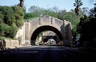
The Figueroa Street Tunnels are a set of four four-lane tunnels that carry northbound traffic on State Route 110 through Elysian Park in Los Angeles, California, United States. From south to north, the four tunnels measure 755, 461, 130, and 405 feet in length, 46.5 feet in width, and 28.3 ft in height.
Hollywood Land is a themed land at Disney California Adventure park at the Disneyland Resort in Anaheim, California. The area is inspired by the 1930s Golden Age period of Hollywood and hosts attractions themed to this concept, including a backlot of a typical Hollywood studio. The land opened as Hollywood Pictures Backlot with the park in 2001.

Interstate 5 (I-5) is a major north–south route of the Interstate Highway System in the United States, running largely parallel to the Pacific Coast between the Mexican border and the Canadian border. The segment of I-5 in California runs across the length of the state from the Mexican border at the San Ysidro Port of Entry in the San Ysidro neighborhood of San Diego to the Oregon state line south of the Medford-Ashland metropolitan area. It is the longest interstate in California at 796.77 miles (1,282.28 km), and accounts for more than half of I-5's total length of 1,381.29 miles (2,222.97 km). It is also the second longest stretch of Interstate Highway with a single designation within a single state after I-10 in Texas.

Toonerville Rifa 13, also known as The Ville, is a Mexican-American street gang located in Los Angeles county.

Glendale Boulevard is a north–south street in Los Angeles. It starts off as Lucas Avenue at 7th Street west of Downtown Los Angeles, California.

The Monrovia–Glendora Line was a route on the Pacific Electric Railway serving the San Gabriel Valley. It operated from 1902 to 1951, supporting nearby real estate development.

Glendale–Burbank is a defunct Pacific Electric railway line that was operational from 1904 to 1955 in Southern California, running from Downtown Los Angeles to Burbank via Glendale. Short lines terminated Downtown and in North Glendale, including the popular Edendale Local.

Buena Vista Street is a themed land at Disney California Adventure amusement park at the Disneyland Resort in Anaheim, California, United States. Though named for Buena Vista Street, the real-life Burbank thoroughfare that the Walt Disney Studios sits on, the central plaza represents Los Angeles, and specifically the Los Feliz area around Hyperion Avenue, in the 1920s when Walt Disney first arrived there. One of the main features is a small-scale replica of the Hyperion Bridge, which was being constructed when Disney stayed in Atwater Village. The replica functions as a working bridge for the resort's monorail system.

The Red Car Trolley is a 3 ft 3+3⁄8 inmeter gauge tramway and transportation attraction at Disney California Adventure at the Disneyland Resort in Anaheim, California. Construction began on January 4, 2010, and the attraction opened on June 15, 2012, as part of the re-dedication of the park. The attraction features cars inspired by the Pacific Electric Railway's "Red Cars" that once traversed much of Southern California, and provides transportation between the park's main entry at Buena Vista Street and Sunset Boulevard in Hollywood Land.

The Los Angeles River bicycle path is a Class I bicycle and pedestrian path in the Greater Los Angeles area running from north to east along the Los Angeles River through Griffith Park in an area known as the Glendale Narrows. The 7.4 mile section of bikeway through the Glendale Narrows is known as the Elysian Valley Bicycle & Pedestrian Path. The bike path also runs from the city of Vernon to Long Beach, California. This section is referred to as LARIO, or more formally, the Los Angeles River Bikeway.

The Glendale Narrows is a scenic 11 mile section of the Los Angeles River in the Northeast Los Angeles region of Los Angeles County, California.


