Los Angeles River Bike Path | |
---|---|
![]() Path at Glendale Narrows | |
Use | Active transportation, road biking, walking, dogs on leash |
Surface | Asphalt |
The Los Angeles River bicycle path is a Class I bicycle and pedestrian path in the Greater Los Angeles area running from north to east along the Los Angeles River through Griffith Park in an area known as the Glendale Narrows. The 7.4 mile section of bikeway through the Glendale Narrows is known as the Elysian Valley Bicycle & Pedestrian Path. [1] The bike path also runs from the city of Vernon to Long Beach, California. This section is referred to as LARIO, or more formally, the Los Angeles River Bikeway.
Following the Los Angeles Flood of 1938, concrete banks were created as a flood control measure for nearly all the length of the river, making it essentially navigable by bicycle to its end, where it empties into the San Pedro Bay in Long Beach. In recent years, the Friends of the Los Angeles River, a local civic and environmental group, have attempted to restore portions of the river as parkland in a manner that includes and encourages bicycle and pedestrian traffic, efforts realized in part as local U.S. Representative Brad Sherman secured $460,000 in federal funds to extend the path north in the Sherman Oaks area.
The LA River Bicycle Path consists of two main parts and other shorter sections that currently do not connect with each other along the river yet. [2] [3]
The Los Angeles River Revitalization Corporation (LARRC, LA River Corp) had campaigned for Greenway 2020, the completion of bike and walk paths for the entire 51-mile river by the year 2020. [4]
The Los Angeles River Bikeway, also known as LARIO, is the longest completed section of the bicycle/pedestrian path. It runs from the Shoreline Pedestrian Bikepath at the river's mouth in Long Beach, upstream to the industrial area southeast of Downtown Los Angeles, at Atlantic Boulevard in Vernon. [5]
In Long Beach, the bike path runs on the east side of the river channel. When the path intersects with Imperial Highway, it crosses the LA River on the road bridge and continues north on along the west side of the LA River to Vernon. [2] The path on the east side continues under the bridge to the confluence with the Rio Hondo, becoming the Rio Hondo Bicycle Path heading northeast to the Whittier Narrows Recreation Area. [2]
Mileage markers are painted on the pavement and signs are posted at regular intervals detailing upcoming city streets. Parking can be found at Hollydale Park in South Gate, [6] Ralph C. Dills Park in Paramount, [7] and DeForest Park in Long Beach. [2] [8] Other access in Long Beach includes several street crossings of the river, including those of Pacific Coast Highway, Willow Street, Wardlow Road, and Del Amo Boulevard.
The second section, the Glendale Narrows Elysian Valley Bicycle Path and pedestrian walkway, runs alongside the L.A. River for 7.4 miles (11.9 km) from the border of Burbank, California & Glendale, California at Victory Blvd and Riverside Drive downstream through the Glendale Narrows to Egret Park in Elysian Valley. [9] [10] It runs through Glendale, Griffith Park, Los Feliz, Atwater Village and Elysian Valley.
The Baum Bicycle Bridge over the river in Los Feliz was built in 2002. [11]
There are numerous entry points and parks along it, including Rio de Los Angeles State Park, Griffith Park, Egret Park, Oso Park, Steelhead Park, Riverdale Mini-Park, Elysian Valley Gateway Park, Marsh Park, Rattlesnake Park, Crystal Park, and Sunnynook River Park. The Glendale Narrows Riverwalk, a separate multi-use (walk/bike) path, is across the river along the northern bank in the city of Glendale. [12] [13] The non-vehicular Garden Bridge project over the Glendale Narrows will connect the Glendale Narrows Elysian Valley Bicycle Path, Griffith Park, and Los Angeles − with the Glendale Narrows Riverwalk and city of Glendale. [14]
In the San Fernando Valley there are several other non-connected sections. [15] [16] A new section is under construction in Reseda to continue it eastward.
A 1.5 mile stretch in Canoga Park from Mason to Owensmouth opened in April 2022, and “the next section of the bike path being planned will go from Vanalden Avenue to Balboa Boulevard in the Sepulveda Basin.” [17]
A half-mile section in “Studio City between Whitsett Avenue and Coldwater Canyon Avenue” opened in 2019. [18]
Further east the North Valleyheart Riverwalk is located in Studio City. [19]
The Arroyo Seco Bicycle Path and Kenneth Newell Bikeway are in the Arroyo Seco river channel, upstream from its confluence with the Los Angeles River. It runs from Montecito Heights northeast to Pasadena.
The Browns Creek Bike Trail runs along Browns Canyon Wash in Chatsworth, at the foot of the Santa Susana Mountains in the northwestern San Fernando Valley.
The Compton Creek Bike Path is in Compton, along the east bank of two sections of Compton Creek, a tributary of the lower Los Angeles River. The northern section of the path is a paved trail extending from El Segundo Boulevard south through residential neighborhoods to Greenleaf Boulevard. An equestrian trail runs along the west bank of the creek.
A shorter section of paved trail exists farther south along the creek, but it is separated by the LA Metro A Line tracks, the Gardena Freeway, and the east fork of Compton Creek. Access to this southern segment is only at a few large streets, and it ends at Del Amo Boulevard north of the confluence of Compton Creek and the Los Angeles River.
The Dominguez Channel Bicycle Path/Laguna Dominguez Bicycle Trail is along a 2.8 miles (4.5 km) section of the Upper Dominguez Channel, a 15.7 miles (25.3 km) long channelized stream west of the lower Los Angeles River in southern Los Angeles County. It runs between the community of Alondra Park near El Camino College and Hawthorne near the Hawthorne Airport. [20] It is a project of the city of Hawthorne's Dominguez Enhancement and Engagement Project (D.E.E.P) [21] [22] It has numerous mid-block crossings with cross walk navigation, and offers good pedestrian access. [20] Periodic mile markers painted on the pavement indicating distances upstream from its mouth at the Port of Los Angeles. [20]
On July 23, 2013, the nonprofit group River LA, formerly known as Los Angeles River Revitalization Corp, announced a goal of completing a continuous 51-mile greenway and bike path along the river by the end of the decade. [23] [24] The path is envisioned to be the central focus of a linear recreational park as well as providing an alternative transportation path through Los Angeles. The announcement by the nonprofit group precedes the expected August 30 release of a feasibility study being prepared by the U.S. Army Corps of Engineers. The Corps have the ultimate decision-making power over the river and its future revitalization. [25]
The Los Angeles River, historically known as Paayme Paxaayt'West River' by the Tongva and the Río Porciúncula'Porciúncula River' by the Spanish, is a major river in Los Angeles County, California. Its headwaters are in the Simi Hills and Santa Susana Mountains, and it flows nearly 51 miles (82 km) from Canoga Park through the San Fernando Valley, Downtown Los Angeles, and the Gateway Cities to its mouth in Long Beach, where it flows into San Pedro Bay. While the river was once free-flowing and frequently flooding, forming alluvial flood plains along its banks, it is currently notable for flowing through a concrete channel on a fixed course, which was built after a series of devastating floods in the early 20th century.
The East Coast Greenway is a 3,000-mile (4,800 km) pedestrian and bicycle route between Maine and Florida along the East Coast of the United States. The nonprofit East Coast Greenway Alliance was created in 1991 with the goal to use the entire route with off-road, shared-use paths; as of 2021, over 1,000 mi (1,600 km) of the route (35%) meets these criteria. In 2020, the Greenway received over 50 million visits.
The Rio Hondo is a tributary of the Los Angeles River in Los Angeles County, California, approximately 16.4 miles (26.4 km) long. As a named river, it begins in Irwindale and flows southwest to its confluence in South Gate, passing through several cities. Above Irwindale its main stem is known as Santa Anita Creek, which extends another 10 miles (16 km) northwards into the San Gabriel Mountains where the source, or headwaters, of the river are found.
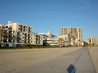
The Marvin Braude Bike Trail is a 22-mile (35 km) paved bicycle path that runs mostly along the shoreline of Santa Monica Bay in Los Angeles County, California. The coastal bike trail is widely acknowledged as Los Angeles' "most popular bike path."
The Coyote Creek bikeway is a Class 1 bike path in Los Angeles County that runs adjacent to the Coyote Creek flood control channel for approximately 9.5 miles. The bike path is controlled by Caltrans. The path begins in Santa Fe Springs on the North fork of the Coyote Creek and extends south into Long Beach where it joins the San Gabriel River bicycle path at the trail bridge just South of Willow Street/Katella Avenue.
The San Gabriel River Trail is a 28-mile (45 km) bike path along the San Gabriel River through El Dorado Regional Park and onto street bike trails near the Alamitos Bay Marina in Los Angeles County, California. The South end is Seal Beach. The northern segment begins near Whittier Narrows Recreation Area.
The Arroyo Seco Bicycle Path is an approximately 2-mile (3.2 km) long Class I bicycle path along the Arroyo Seco river channel and canyon in the Northeast Los Angeles region of Los Angeles County, California. It parallels the Arroyo Seco Parkway, which is also a part of the canyon.
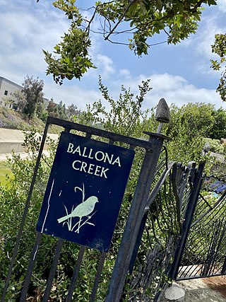
The Ballona Creek Bike Path is a 6.7-mile (10.8 km) Class I bicycle path and pedestrian route in California. The bike path follows the north bank of Ballona Creek until it reaches Santa Monica Bay at the Pacific Ocean. The route is defined by, and recognized for, the dramatic contrast between the channelized waterway’s stark cement geometry and the abundant wildlife of the verdant Ballona Wetlands.
Elysian Valley, commonly known as Frogtown, is a neighborhood in Central Los Angeles, California. Elysian Valley is located between the Golden State Freeway and the Los Angeles River. The area is a narrow strip of land approximately 3 miles long, bordered by the Los Angeles River to the north and east, Riverside Drive to the west, and Fletcher Drive to the northwest. This distinctive geographic positioning has significantly contributed to the neighborhood's unique character.
The Manhattan Waterfront Greenway is a waterfront greenway for walking or cycling, 32 miles (51 km) long, around the island of Manhattan, in New York City. The largest portions are operated by the New York City Department of Parks and Recreation. It is separated from motor traffic, and many sections also separate pedestrians from cyclists. There are three principal parts — the East, Harlem and Hudson River Greenways.
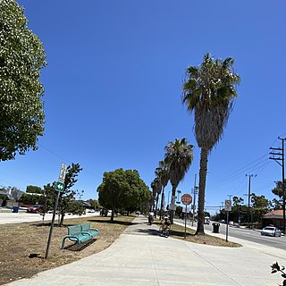
The Culver Boulevard Median Bike Path is Class I rail trail bicycle path, walk route and linear park on Culver Boulevard in western Los Angeles County, California.
The Glendale Narrows is a scenic 11 mile section of the Los Angeles River in the Northeast Los Angeles region of Los Angeles County, California.
The Shoreline Pedestrian Bikepath also known as the Long Beach Bike Path is a 4.5-mile (7.2 km) path along the Pacific Ocean from Shoreline Village in downtown Long Beach, California to Belmont Shore, Los Angeles County. It was completed in 1988 and is used by walkers, joggers, and skaters. In 2013 the California Coastal Commission approved a second path for pedestrians to run parallel to the path used primarily by bicyclists.
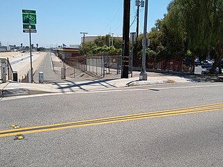
Los Angeles River Bikeway, also known as LARIO, is a 29.1 mi (46.8 km) bikeway along the lower Los Angeles River in southern Los Angeles County, California. It is one of the completed sections of the Los Angeles River Bicycle Path planned to run along the entire 51 miles (82 km) length of the LA River.
The Expo Bike Path is a 12-mile-long (19 km) rail with trail bicycle path and pedestrian route in Los Angeles County, California that travels roughly parallel to the Los Angeles Metro Rail's E Line between La Cienega/Jefferson and 17th Street/SMC stations. The Expo Bike Path is one of two major bicycle routes in Los Angeles that share dedicated rights-of-way with public transport, the other being the G Line Bikeway in the San Fernando Valley.
The Tujunga Wash Greenway and Bike Path is a trail and stormwater mitigation project in the Valley Village and Valley Glen neighborhoods of California’s San Fernando Valley.