Culver Boulevard Median Bike Path

Last updated

The Culver Boulevard Median Bike Path is Class I rail trail bicycle path, walk route and linear park on Culver Boulevard in western Los Angeles County, California.

Contents

Culver Boulevard Median Bike Path
Culver Boulevard Median Bike Path, western terminus.jpg
Bike path western terminus
Length2.1 mi (3.4 km)
LocationLos Angeles County, California, United States
Established1996
Trailheads Elenda Street
34°00′36″N118°24′21″W / 34.01002°N 118.40596°W / 34.01002; -118.40596 (Northeastern trailhead)
McConnell Ave.
33°59′08″N118°25′32″W / 33.98553°N 118.42567°W / 33.98553; -118.42567 (Southwestern trailhead)
UseActive transport, road biking, walking, dogs on leash
DifficultyEasy
Right of way Redondo Beach via Playa del Rey Line
Maintained by Culver City, LADOT

Route

The path is currently 2.1 miles (3.4 km) in length. The northeastern terminus is Elenda Street in Culver City; the southwestern terminus is at McConnell Ave. in the Los Angeles neighborhood of Del Rey.

Culver is split lengthwise by the median, the streets on either side are both called Culver Boulevard on maps. The northern Culver, commonly called "Little Culver," is restricted to local traffic with dead ends blocking access from major intersections; [1] [2] "Big Culver" is the major automobile throughway on the south side that continues past the end of the bike route toward a wedge-shaped intersection with Jefferson Boulevard at the Ballona Wetlands. [3]

The path passes under Interstate 405 and passes over Sepulveda Creek channel.

At the eastern terminus, cyclists can take Culver City's Elenda Bikeway (south to the Ballona Creek Pedestrian Bridge or north to Washington and then jog over to Girard Avenue to reach the Venice Boulevard bike route). [4] [5]

Facing "Big Culver," with salvaged architectural details from the demolished 1928 Culver City City Hall building. Culver Boulevard Median Bike Path, facing "Big Culver".jpg
Facing "Big Culver," with salvaged architectural details from the demolished 1928 Culver City City Hall building.

At the western terminus, close to the former Alla Junction of the Pacific Electric streetcar system, cyclists can turn south to access the Ballona Creek Bike Path and the connecting Marvin Braude Bike Trail [7] or segue past the storage facility down Panama Street toward Glen Alla Park and Marina Del Rey shopping centers.

A pedestrian path parallels the bike path for most of the median's extent; benches and open green spaces line the route. The surface of the bike path is asphalt; the surface material of pedestrian track varies between asphalt and decomposed granite.

A street vendor offering chicharrones
crosses the footbridge over Sepulveda Creek channel; due to the narrow bridge the usually separate pedestrian and bike paths along the route briefly converge at this pinch point. Street vendor along Culver Boulevard Median, crossing Sepulveda Creek.jpg
A street vendor offering chicharrónes crosses the footbridge over Sepulveda Creek channel; due to the narrow bridge the usually separate pedestrian and bike paths along the route briefly converge at this pinch point.

Access points

Pedestrian track, pollinator-friendly plantings, and paved cycle route Culver Boulevard Median Bike Path pollinator plantings.jpg
Pedestrian track, pollinator-friendly plantings, and paved cycle route

The path is flat along its entire length. Although small residential streets do not cross the median, at major streets cyclists must yield to vehicle traffic and cross when appropriate using pedestrian crosswalks.

Access ramps at major crossings, east to west:

Access ramps for bike and pedestrian path only, Big Culver side:

Access ramps for bike and pedestrian path only, Little Culver side:

History

Berryman Avenue crossing Pacific Electric Del Rey Line near Culver City, looking north along Berryman Avenue, 1926; the shelter on the left may have been a transit stop Berryman Avenue crossing Pacific Electric Del Rey Line 1926.jpg
Berryman Avenue crossing Pacific Electric Del Rey Line near Culver City, looking north along Berryman Avenue, 1926; the shelter on the left may have been a transit stop

The median is a rail trail, using the right-of-way of a route that was originally the Redondo Beach via Playa del Rey Line. The tracks were used by Pacific Electric Red Cars passenger trolleys until World War II, and later used by Southern Pacific Railroad to haul freight. [8]

"Through the co-operation of Southern Pacific" Culver City landscaped a section of the Culver Blvd. median with "trees, shrubbery and a sprinkler system" in 1966 "to obscure railroad tracks." This three-quarter mile (1.2 km) stretch of approximately between Jackson Avenue and Elenda Street is currently beyond the extent of the bike path. [9]

Culver City purchased their remaining section of the right-of-way from Southern Pacific and landscaped it some time before 1985. [10]

In the early 1980s, developers sought to build housing on the Los Angeles section [10] but their plans were rejected by the city council. [2]

In 1996, the median officially became a class I bike route when Culver City redesigned the .75 miles (1.21 km) section located in Culver City between Elenda and Sawtelle, and established separate walking and biking paths protected from adjacent car traffic. [11]

Los Angeles initiated an improvement project for the stretch between Sawtelle and McConnell in 1997, prior to which "On the Los Angeles section, a 60 feet (18 m)-wide swath of dirt and weeds cuts through residential neighborhoods. Discarded furniture, including mattresses and sofas, and broken-down appliances often are dumped along the median. Cars and trucks, even 18-wheel big rigs, park there." [8]

Culver Blvd. Median Bike Path, at Sepulveda Blvd. (L to R: "Little Culver," paved bike path, pedestrian footpath, "Big Culver" Culver Blvd. Median Bike Path, at Sepulveda Blvd.jpg
Culver Blvd. Median Bike Path, at Sepulveda Blvd. (L to R: "Little Culver," paved bike path, pedestrian footpath, "Big Culver"

The section from Sepulveda Boulevard west to Berryman was repaved and re-striped.[ when? ] In 2022, the Culver City section between Elenda and Sepulveda was reconstructed and replanted as part of a larger project that "installed underground water features to detain rainwater and other urban run-off, for both infiltration and for use for irrigation." [12] [13] [14]

The cities of Los Angeles and Culver City are each responsible for the maintenance of the portions of the path that fall within their respective city limits.

See also

Related Research Articles

<span class="mw-page-title-main">Culver City, California</span> City in Los Angeles County, California, US

Culver City is a city in Los Angeles County, California, United States. As of the 2020 census, the population was 40,779.

<span class="mw-page-title-main">Playa del Rey, Los Angeles</span> Neighborhood of Los Angeles in California, United States

Playa del Rey is a seaside suburb in the Santa Monica Bay and the South Bay region of Los Angeles County, California. It has a ZIP code of 90293 and area codes of 310 and 424. As of 2018, the community had a population of 16,230 people.

<span class="mw-page-title-main">Sepulveda Dam</span> Dam in San Fernando Valley, California

The Sepulveda Dam is a dry dam constructed by the U.S. Army Corps of Engineers to withhold winter flood waters along the Los Angeles River. Completed in 1941, at a cost of $6,650,561, it is located south of center in the San Fernando Valley, approximately eight miles (13 km) east of the river's source in the western end of the Valley, in Los Angeles, California.

<span class="mw-page-title-main">Playa Vista, Los Angeles</span> Neighborhood of Los Angeles in California, United States

Playa Vista is a neighborhood in the Westside area of Los Angeles, California, United States. The area was the headquarters of Hughes Aircraft Company from 1941 to 1985 and the site of the construction of the Hughes H-4 Hercules "Spruce Goose" aircraft. The area began development in 2002 as a planned community with residential, commercial, and retail components. The community attracted businesses in technology, media and entertainment and is part of Silicon Beach.

<span class="mw-page-title-main">Ballona Creek</span> Urbanized river in Los Angeles, California, United States.

Ballona Creek is an 8.5-mile (13.7 km) channelized stream in southwestern Los Angeles County, California, United States, that was once a "year-round river lined with sycamores and willows". The urban watercourse begins in the Mid-City neighborhood of Los Angeles, flows through Culver City and Del Rey, and passes the Ballona Wetlands Ecological Preserve, the sailboat harbor Marina del Rey, and the small beachside community of Playa del Rey before draining into Santa Monica Bay. The Ballona Creek drainage basin carries water from the Santa Monica Mountains on the north, from the Baldwin Hills to the south, and as far as the Harbor Freeway (I-110) to the east.

<span class="mw-page-title-main">Sepulveda Boulevard</span> Street in Los Angeles, California

Sepulveda Boulevard is a major street and transportation corridor in the City of Los Angeles and several other cities in western Los Angeles County, California. The street parallels Interstate 405 for much of its route. Portions of Sepulveda Boulevard between Manhattan Beach and Los Angeles International Airport (LAX) are designated as part of State Route 1.

<span class="mw-page-title-main">Marvin Braude Bike Trail</span> Bike path in Los Angeles County, California, United States

The Marvin Braude Bike Trail is a 22-mile (35 km) paved bicycle path that runs mostly along the shoreline of Santa Monica Bay in Los Angeles County, California. The coastal bike trail is widely acknowledged as Los Angeles’ “most popular bike path.”

<span class="mw-page-title-main">Ballona Creek Bike Path</span> Cycling route in Los Angeles County, California

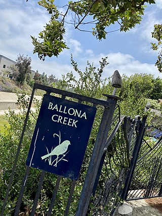
The Ballona Creek Bike Path is a 6.7-mile (10.8 km) Class I bicycle path and pedestrian route in California. The bike path follows the north bank of Ballona Creek until it reaches Santa Monica Bay at the Pacific Ocean. The route is defined by, and recognized for, the dramatic contrast between the channelized waterway’s stark cement geometry and the abundant wildlife of the verdant Ballona Wetlands.

<span class="mw-page-title-main">Centinela Avenue</span> Street in Los Angeles County, United States

Centinela Avenue is a 10.2 mile major street in the Westside region of Los Angeles County, California.

<span class="mw-page-title-main">Sawtelle Boulevard</span> Thoroughfare in Los Angeles

Sawtelle Boulevard is a north/south street in the Westside region of the city of Los Angeles, California. For most of its length, it parallels the San Diego Freeway, one block to the east.

<span class="mw-page-title-main">Los Angeles River bicycle path</span> Cycling route in California, USA

The Los Angeles River bicycle path is a Class I bicycle and pedestrian path in the Greater Los Angeles area running from north to east along the Los Angeles River through Griffith Park in an area known as the Glendale Narrows. The 7.4 mile section of bikeway through the Glendale Narrows is known as the Elysian Valley Bicycle & Pedestrian Path. The bike path also runs from the city of Vernon to Long Beach, California. This section is referred to as LARIO, or more formally, the Los Angeles River Bikeway.

<span class="mw-page-title-main">Venice–Inglewood Line</span> Historic rail route in California

The Venice–Inglewood Line is a former Pacific Electric interurban railway line in Los Angeles County, California. Service was very sparse, providing a suburban route between Venice and Inglewood.

<span class="mw-page-title-main">Redondo Beach via Playa del Rey Line</span> Historic streetcar line in California

The Redondo Beach via Playa del Rey was an interurban railway route of the Pacific Electric. It operated between the Hill Street Terminal and Cliffton, south of Redondo Beach, through the company's Western Division.

<span class="mw-page-title-main">Expo Bike Path</span> Rail with trail bicycle path in Los Angeles County, California

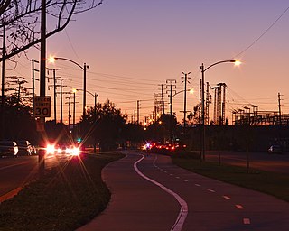
The Expo Bike Path is a 12-mile-long (19 km) rail with trail bicycle path and pedestrian route in Los Angeles County, California that travels roughly parallel to the Los Angeles Metro Rail's E Line between La Cienega/Jefferson and 17th Street/SMC stations. The Expo Bike Path is one of two major bicycle routes in Los Angeles that share dedicated rights-of-way with public transport, the other being the G Line Bikeway in the San Fernando Valley.

<span class="mw-page-title-main">Park to Playa Trail</span> Recreation path in California, US

The Park to Playa Trail in Los Angeles County, California is a 13-mile (21 km) pedestrian and bicycle route that connects the Baldwin Hills parklands to the Pacific Ocean. According to the Los Angeles Times, “Good views of L.A. are guaranteed on the dirt-and-paved track from Baldwin Hills to Playa del Rey.”

<span class="mw-page-title-main">Chandler Boulevard Bike Path</span> Cycling route in San Fernando Valley, California, USA

The Chandler Boulevard Bike Path is a Class I rail trail off-street bike route that runs from North Hollywood to Burbank in Los Angeles County, California.

<span class="mw-page-title-main">G Line Bikeway</span> Cycle route in Los Angeles County, California

The G Line Bikeway is a cycle route in Los Angeles County, California, that runs for 17.9 miles (28.8 km) and “spans the lengths of the San Fernando Valley’s major communities” from Chatsworth to Valley Glen, “connecting such places as Pierce College, the Sepulveda Basin Recreation Area, the Van Nuys Government Center and Valley College.”

<span class="mw-page-title-main">Culver Boulevard</span> Thoroughfare in Los Angeles, California

Culver Boulevard is an east-west thoroughfare in the Westside region of Los Angeles County, California, connecting Venice Boulevard to the coast roads.

References

  1. Observer, Culver City. "Controversial Culver Blvd. Realignment Will Begin". Culver City Observer. Archived from the original on 2022-06-22. Retrieved 2022-06-22.
  2. 1 2 Pae, Peter, "Plan for Apartments on Culver Blvd. Rejected," Los Angeles Times, 31 July 1986.
  3. Broverman, Neal (2014-01-30). "Wide-Ass Culver Blvd. Getting New Turn Lanes and Bike Path". Curbed LA. Archived from the original on 2021-09-26. Retrieved 2022-06-22.
  4. "Eyes on the Street: New Two-Way Protected Lanes on Elenda in Culver City". Streetsblog Los Angeles. 2021-09-17. Archived from the original on 2022-08-03. Retrieved 2022-06-15.
  5. "Ribbon Cutting Launches Bike Lane and Crosswalks for 'Safe Routes to School' @ La Ballona Elementary – Culver City Crossroads". Archived from the original on 2022-06-22. Retrieved 2022-06-22.
  6. Observer, Culver City. "Culver Blvd. Will Get A Makeover". Culver City Observer. Archived from the original on 2022-06-22. Retrieved 2022-06-22.
  7. "Culver Boulevard Bike Path". www.traillink.com. Archived from the original on 2021-10-29. Retrieved 2022-06-22.
  8. 1 2 Yates, Nona (18 Feb 1997). "Turning Medians From Eyesores Into Urban Oases". Los Angeles Times.
  9. "Culver City OKs Street Landscaping," Los Angeles Times, 1966-03-17, p. WS5.
  10. 1 2 Graham, Nancy, "400 Urge Russell to Oppose Culver Boulevard Proposal," Los Angeles Times, Sep 12, 1985.
  11. "Officials Hope Bikeway Will Boost Revitalization Effort". Los Angeles Times. 20 Dec 1996.
  12. Linton, Joe (2022-08-01). "Eyes on the Street: Culver City's Renovated Culver Blvd Bikeway". Streetsblog Los Angeles. Archived from the original on 2022-08-03. Retrieved 2022-08-03.
  13. "Culver Boulevard Realignment & Urban Stormwater Project". www.culvercity.org. Archived from the original on 2022-06-22. Retrieved 2022-06-22.
  14. Martin-Straw, Judith; Rocha, Amy (2022-07-01). "Stormwater Project Gets Official Celebration". Culver City Crossroads. Archived from the original on 2022-07-02. Retrieved 2022-07-02.