Chandler Boulevard Bike Path

Last updated
Chandler Boulevard Bike Path
Chandler bike path evening burbank.jpg
Bike path, Burbank, evening
Length2.8 mi (4.5 km)
Location Los Angeles County
Established2004
Trailheads 34°10′07″N118°22′12″W / 34.1685°N 118.3701°W / 34.1685; -118.3701 , 34°10′46″N118°19′27″W / 34.1794°N 118.3243°W / 34.1794; -118.3243
UseActive transportation, road biking, pedestrians, dogs on leash
DifficultyEasy
Surface Asphalt
Right of way Southern Pacific Burbank Branch
Maintained by LADOT
Burbank Transportation Commission

The Chandler Boulevard Bike Path is a Class I rail trail off-street bike route that runs from North Hollywood to Burbank in Los Angeles County, California.

Contents

Chandler Blvd. Bikeway was the Southern Pacific Burbank Branch railroad track until the 1980s. [1] [2] The path has separate bicycle and pedestrian lanes, sculpture, murals, pleasant landscaping and impressive views of the Verdugo Mountains. [3] [4] [5] Chandler Boulevard cyclists and pedestrians have “easy access to…shops and restaurants” in the North Hollywood neighborhood of Los Angeles and a “tranquil trip through residential areas” of the incorporated city of Burbank. [6]

The separated section of the bikeway extends from Mariposa Street in Burbank to Vineland Avenue in North Hollywood. [7] The municipal boundary is at Clybourn Avenue. [2] The western end of the bike path is readily accessible from the combined North Hollywood station of B Line train and G Line bus rapid transit route. [8] [4]

The Chandler Boulevard Bike Path is owned by the Los Angeles County Metropolitan Transportation Authority (commonly known as Metro), and is maintained by Los Angeles' and Burbank's respective transportation departments with funding provided by Metro.

Future improvements and extensions

Recent improvements to the North Hollywood section of the bikeway included exercise equipment, a children's playground, a fenced dog run, street furniture, and, at Denny Avenue, a new crosswalk and ADA ramp improvements. [9]

The Chandler Bicycle Connection project, completed 2021, is a Class III 3 mi (4.8 km) sharrows route that connects the end of the Orange Line Bike Path to the beginning of the protected bike route on the median in North Hollywood, Los Angeles. [10] [11] Converting this stretch to protected bike lanes is underway with a projected completion date of 2023. [12]

In 2020, the Burbank City Council approved an extension to the Burbank Metrolink station along a route that will include the under-construction Burbank Channel Bikeway [13] and a connection to the San Fernando Bikeway. [14]

See also

Related Research Articles

<span class="mw-page-title-main">Sepulveda Dam</span> Dam in San Fernando Valley, California

The Sepulveda Dam is a project of the U.S. Army Corps of Engineers designed to withhold winter flood waters along the Los Angeles River. Completed in 1941, at a cost of $6,650,561, it is located south of center in the San Fernando Valley, approximately eight miles east of the river's source in the western end of the Valley, in Los Angeles, California.

<span class="mw-page-title-main">Civic Center/Grand Park station</span> Los Angeles Metro Rail station

Civic Center/Grand Park station is an underground rapid transit station on the B Line and D Line of the Los Angeles Metro Rail system. The station also has street level stops for the J Line of the Los Angeles Metro Busway system. The station is located under Hill Street at its intersection with 1st Street. It is located in the Civic Center neighborhood of Los Angeles, after which the station is named, alongside the nearby Grand Park.

<span class="mw-page-title-main">North Hollywood station</span> Los Angeles Metro Rail station

North Hollywood station is a combined rapid transit and bus rapid transit (BRT) station in the Los Angeles Metro Rail and Metro Busway systems. It is the northwestern terminus of the B Line subway and eastern terminus of the G Line BRT route. It is located at the intersection of Lankershim Boulevard and Chandler Boulevard in the NoHo Arts District of the North Hollywood neighborhood in the San Fernando Valley of Los Angeles.

<span class="mw-page-title-main">Marvin Braude Bike Trail</span> Bike path in Los Angeles County, California, United States

The Marvin Braude Bike Trail is a 22-mile (35 km) paved bicycle path that runs mostly along the shoreline of Santa Monica Bay in Los Angeles County, California. The coastal bike trail is widely acknowledged as Los Angeles’ “most popular bike path.”

<span class="mw-page-title-main">San Gabriel River Bike Trail</span> Cycling route in Southern California, USA

The San Gabriel River Trail is a 28-mile (45 km) bike path along the San Gabriel River through El Dorado Regional Park and onto street bike trails near the Alamitos Bay Marina in Los Angeles County, California. The South end is Seal Beach. The northern segment begins near Whittier Narrows Recreation Area.

<span class="mw-page-title-main">Arroyo Seco bicycle path</span> Cycling route in California, USA

The Arroyo Seco Bicycle Path is an approximately 2-mile (3.2 km) long Class I bicycle path along the Arroyo Seco river channel in the Northeast Los Angeles region of Los Angeles County, California. It parallels to the Arroyo Seco Parkway also in the canyon.

<span class="mw-page-title-main">Ballona Creek Bike Path</span> Cycling route in Los Angeles County, California

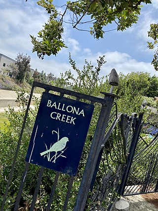
The Ballona Creek Bike Path is a 6.7-mile (10.8 km) Class I bicycle path and pedestrian route in California. The bike path follows the north bank of Ballona Creek until it reaches Santa Monica Bay at the Pacific Ocean. The route is defined by, and recognized for, the dramatic contrast between the channelized waterway’s stark cement geometry and the abundant wildlife of the verdant Ballona Wetlands.

<span class="mw-page-title-main">Balboa station</span> Rapid-transit bus stop in San Fernando Valley, Los Angeles, California

Balboa station is a station on the G Line of the Los Angeles Metro Busway system. It is named after adjacent Balboa Boulevard, which travels north–south and crosses the east–west transitway route. The station is in the Lake Balboa district of Los Angeles, in the central San Fernando Valley.

<span class="mw-page-title-main">Van Nuys station (Los Angeles Metro)</span> Rapid-transit bus stop in San Fernando Valley, Los Angeles, California

Van Nuys station is a station on the G Line of the Los Angeles Metro Busway system. It is named after adjacent Van Nuys Boulevard, which travels north-south and crosses the east-west busway route and is located in the Van Nuys district of Los Angeles, in the San Fernando Valley. Adjacent to the station is the G Line's bicycle path.

<span class="mw-page-title-main">Culver Boulevard Median Bike Path</span> Rail-trail cycle route in California, United States

The Culver Boulevard Median Bike Path is Class I rail trail bicycle path, walk route and linear park on Culver Boulevard in western Los Angeles County, California.

Los Angeles can refer to both the City of Los Angeles and Los Angeles County, as well as the larger Los Angeles region.

<span class="mw-page-title-main">Cycling in Los Angeles</span> Bike usage in California’s most populous city and county

Cycling in Los Angeles accounts for less than one percent (0.6%) of all work commutes. Because of the mild climate, there is little need to carry the variety of clothing that cyclists require in other less temperate climates.

<span class="mw-page-title-main">Los Angeles River bicycle path</span> Cycling route in California, USA

The Los Angeles River bicycle path is a Class I bicycle and pedestrian path in the Greater Los Angeles area running from north to east along the Los Angeles River through Griffith Park in an area known as the Glendale Narrows. The 7.4 mile section of bikeway through the Glendale Narrows is known as the Elysian Valley Bicycle & Pedestrian Path. The bike path also runs from the city of Vernon to Long Beach, California. This section is referred to as LARIO, or more formally, the Los Angeles River Bikeway.

<span class="mw-page-title-main">Expo Line Bikeway</span> Rail-trail bicycle route in California, United States

The Expo Line Bikeway is a 12-mile (19 km) Los Angeles County, California rail with trail bicycle path and pedestrian route that travels roughly parallel to the Metro’s E Line train tracks between the Exposition Park area near the USC campus and downtown Santa Monica near the Pacific Ocean. The Expo Line Bikeway is one of two major bicycle routes in Los Angeles that share dedicated rights-of-way with mass transit, the other being the Orange Line Bikeway in the San Fernando Valley.

Browns Creek Bike Path is a Class I bike path that is “tucked away from the surrounding hustle and bustle” of the San Fernando Valley, “hugging the side” of the Browns Canyon Wash.

<span class="mw-page-title-main">Kenneth Newell Bikeway</span> Cycling route in Pasadena, California, USA

The Kenneth Newell Bikeway in Pasadena is one of the first bike paths established in Los Angeles County. This “popular, well-marked bikeway” has been called “one of the premier inland trips.” The path travels through the canyon of the Arroyo Seco river, a tributary of the Los Angeles River.

<span class="mw-page-title-main">Tujunga Wash Greenway</span> Cycling route in California, USA

The Tujunga Wash Greenway and Bike Path is a trail and stormwater mitigation project in the Valley Village and Valley Glen neighborhoods of California’s San Fernando Valley.

<span class="mw-page-title-main">Orange Line Bikeway</span> Rail-trail bicycle route in California, U.S.

The Orange Line Bikeway is a cycle route in Los Angeles County, California that runs 17.9 miles (28.8 km) and “spans the lengths of the San Fernando Valley’s major communities” from Chatsworth to North Hollywood, “connecting such places as Pierce College, the Sepulveda Basin Recreation Area, the Van Nuys Government Center and Valley College.”

References

  1. "City of Burbank". Twitter. 2019-05-02. Archived from the original on 2022-09-14. Retrieved 2022-08-13.
  2. 1 2 "Chandler Bikeway | California Trails | TrailLink". www.traillink.com. Archived from the original on 2022-08-13. Retrieved 2022-08-13.
  3. "Chandler Bikeway | Things to do in Burbank". Visit Burbank. Archived from the original on 2022-08-13. Retrieved 2022-08-13.
  4. 1 2 "Chandler Bike Path Loop". Metro Bike Share. 2020-09-28. Archived from the original on 2022-09-14. Retrieved 2022-08-13.
  5. "Chandler Bikeway". Time Out Los Angeles. Archived from the original on 2022-08-13. Retrieved 2022-08-13.
  6. Path, Higher (2020-10-15). "Valley Cycling: Sherman Oaks Bike Trails". The Higher Path Collective. Archived from the original on 2022-08-13. Retrieved 2022-08-13.
  7. Carpio, Anthony Clark (2020-03-26). "Burbank's Chandler Bikeway draws outdoor enthusiasts taking a break from shelter-in-place measures". Burbank Leader. Archived from the original on 2022-08-13. Retrieved 2022-08-13.
  8. Linton, Joe (2020-01-29). "Thirteen Fun Family-Friendly Bike Rides Accessible Via Metro Transit". Streetsblog Los Angeles. Archived from the original on 2022-07-09. Retrieved 2022-08-13.
  9. City News Service (2019-09-04). "LA puts $1.2 million into Chandler Bikeway in North Hollywood". Daily News. Archived from the original on 2022-09-14. Retrieved 2022-08-13.
  10. "ACTIVE TRANSPORTATION - Chandler Bicycle Connection". LADOT Livable Streets. Archived from the original on 2022-08-04. Retrieved 2022-08-13.
  11. "LADOT Livable Streets: Chandler Bicycle Connection" (PDF). 2021. Archived (PDF) from the original on 2022-02-11. Retrieved 2022-08-13.
  12. CiclaValley, Mr (2021-03-03). "Chandler Bicycle Connection Closer to Adding Protected Lanes". CiclaValley. Archived from the original on 2022-08-13. Retrieved 2022-08-13.
  13. Carpio, Anthony Clark (2020-02-29). "Chandler Bikeway to be extended, connect with Burbank Channel Bikeway". Burbank Leader. Archived from the original on 2022-08-13. Retrieved 2022-08-13.
  14. "Chandler Bikeway Extension Project". City of Burbank. Archived from the original on 2022-08-13. Retrieved 2022-08-13.