Rio Hondo bicycle path

Last updated
Rio Hondo Bike Path
Rio Hondo Bike Path.jpg
Between El Monte Airport and Rosemead Blvd
Length1.6 mi (2.6 km)
Location Los Angeles County
UseActive transportation, road biking, walking, dogs on leash
DifficultyEasy
Surface asphalt
Rio Hondo bike path at Rosemead Blvd Rio Hondo at Rosemead.jpg
Rio Hondo bike path at Rosemead Blvd

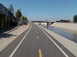
The Rio Hondo Bike Path is a bicycle path that parallels the Rio Hondo (creek) through the San Gabriel Valley, in eastern Los Angeles County, California. [1] The path is gently graded, and has sections with more greenery and mature trees than other bicycle paths in the area. [1] Rio Hondo means deep river in Spanish. [2]

Contents

The proximity of the Rio Hondo Bike Path to the central regional transit hub at the El Monte Station, including the MetroLink J Line, makes it one of the most accessible routes to access a variety of bike paths and local parks.

Route

The northern start of the Rio Hondo Bike Path is at the Peck Road Water Conservation Park in the southern Monrovia area. [3] [4]

From there, the southbound path follows along a rural stream bed through the Whittier Narrows Recreation Area. One can connect to the San Gabriel River bicycle path via the Legg Lake bicycle path here. [1] The Rio Hondo bike path continues south and joins Los Angeles River bicycle path at the confluence of the Rio Hondo and Los Angeles River in South Gate. The L.A. River bike path continues to downtown Long Beach, ending by the Pacific Ocean. [1]

Related Research Articles

<span class="mw-page-title-main">Los Angeles River</span> River in Los Angeles County, California, US

The Los Angeles River, historically known as Paayme Paxaayt by the Tongva and the Porciúncula River by the Spanish, is a major river in Los Angeles County, California. Its headwaters are in the Simi Hills and Santa Susana Mountains, and it flows nearly 51 miles (82 km) from Canoga Park through the San Fernando Valley, Downtown Los Angeles, and the Gateway Cities to its mouth in Long Beach, where it flows into San Pedro Bay. While the river was once free-flowing and frequently flooding, forming alluvial flood plains along its banks, it is currently notable for flowing through a concrete channel on a fixed course, which was built after a series of devastating floods in the early 20th century.

<span class="mw-page-title-main">San Gabriel Valley</span> Populated valley in Southern California, United States

The San Gabriel Valley, often referred to by its initials as SGV, is one of the principal valleys of Southern California, lying immediately to the east of the eastern limits of the city of Los Angeles and occupying the vast majority of the southeastern part of Los Angeles County. Surrounding landforms and other features include the following:

<span class="mw-page-title-main">Sepulveda Dam</span> Dam in San Fernando Valley, California

The Sepulveda Dam is a project of the U.S. Army Corps of Engineers designed to withhold winter flood waters along the Los Angeles River. Completed in 1941, at a cost of $6,650,561, it is located south of center in the San Fernando Valley, approximately eight miles east of the river's source in the western end of the Valley, in Los Angeles, California.

<span class="mw-page-title-main">Rio Hondo (California)</span> River in California, United States

The Rio Hondo is a tributary of the Los Angeles River in Los Angeles County, California, approximately 16.4 miles (26.4 km) long. As a named river, it begins in Irwindale and flows southwest to its confluence in South Gate, passing through several cities. Above Irwindale its main stem is known as Santa Anita Creek, which extends another 10 miles (16 km) northwards into the San Gabriel Mountains where the source, or headwaters, of the river are found.

<span class="mw-page-title-main">San Gabriel River (California)</span> River in Los Angeles County, California, United States

The San Gabriel River is a mostly urban waterway flowing 58 miles (93 km) southward through Los Angeles and Orange Counties, California in the United States. It is the central of three major rivers draining the Greater Los Angeles Area, the others being the Los Angeles River and Santa Ana River. The river's watershed stretches from the rugged San Gabriel Mountains to the heavily developed San Gabriel Valley and a significant part of the Los Angeles coastal plain, emptying into the Pacific Ocean between the cities of Long Beach and Seal Beach.

<span class="mw-page-title-main">Marvin Braude Bike Trail</span> Bike path in Los Angeles County, California, United States

The Marvin Braude Bike Trail is a 22-mile (35 km) paved bicycle path that runs mostly along the shoreline of Santa Monica Bay in Los Angeles County, California. The coastal bike trail is widely acknowledged as Los Angeles’ “most popular bike path.”

<span class="mw-page-title-main">Whittier Narrows</span>

The Whittier Narrows is a narrows or water gap in the San Gabriel Valley of Los Angeles County, California, United States, between the Puente Hills to the east and the Montebello Hills to the west. The gap is located at the southern boundary of the San Gabriel Valley, through which the Rio Hondo and the San Gabriel River flow to enter the Los Angeles Basin. The Narrows is located near the convergence of Interstate 605 and California State Route 60.

<span class="mw-page-title-main">San Gabriel River Bike Trail</span> Cycling route in Southern California, USA

The San Gabriel River Trail is a 28-mile (45 km) bike path along the San Gabriel River through El Dorado Regional Park and onto street bike trails near the Alamitos Bay Marina in Los Angeles County, California. The South end is Seal Beach. The northern segment begins near Whittier Narrows Recreation Area.

<span class="mw-page-title-main">Arroyo Seco bicycle path</span> Cycling route in California, USA

The Arroyo Seco Bicycle Path is an approximately 2-mile (3.2 km) long Class I bicycle path along the Arroyo Seco river channel and canyon in the Northeast Los Angeles region of Los Angeles County, California. It parallels the Arroyo Seco Parkway, which is also a part of the canyon.

<span class="mw-page-title-main">Ballona Creek Bike Path</span> Cycling route in Los Angeles County, California

The Ballona Creek Bike Path is a 6.7-mile (10.8 km) Class I bicycle path and pedestrian route in California. The bike path follows the north bank of Ballona Creek until it reaches Santa Monica Bay at the Pacific Ocean. The route is defined by, and recognized for, the dramatic contrast between the channelized waterway’s stark cement geometry and the abundant wildlife of the verdant Ballona Wetlands.

Foothill Boulevard is a major road in the city and county of Los Angeles, as well as an arterial road in the city and county of San Bernardino, stretching well over 60 miles (97 km) in length, with some notable breaks along the route. Like its name implies, Foothill Boulevard runs across the foothills of the San Gabriel and San Bernardino Mountains.

<span class="mw-page-title-main">Cypress Park, Los Angeles</span> Neighborhood of Los Angeles

Cypress Park is a densely populated neighborhood of 10,000+ residents in Northeast Los Angeles, California. Surrounded by hills on three sides, it sits in the valley created by the Los Angeles River and the Arroyo Seco. It is the site of the Rio de Los Angeles State Park, the Los Angeles River Bike Path and other recreational facilities. It hosts one private and four public schools.

<span class="mw-page-title-main">Eaton Canyon</span>

Eaton Canyon is a major canyon beginning at the Eaton Saddle near Mount Markham and San Gabriel Peak in the San Gabriel Mountains in the Angeles National Forest, United States. Its drainage flows into the Rio Hondo river and then into the Los Angeles River. It is named after Judge Benjamin S. Eaton, who lived in the Fair Oaks Ranch House in 1865 not far from Eaton Creek.

<span class="mw-page-title-main">Los Angeles River bicycle path</span> Cycling route in California, USA

The Los Angeles River bicycle path is a Class I bicycle and pedestrian path in the Greater Los Angeles area running from north to east along the Los Angeles River through Griffith Park in an area known as the Glendale Narrows. The 7.4 mile section of bikeway through the Glendale Narrows is known as the Elysian Valley Bicycle & Pedestrian Path. The bike path also runs from the city of Vernon to Long Beach, California. This section is referred to as LARIO, or more formally, the Los Angeles River Bikeway.

<span class="mw-page-title-main">Los Angeles River Bikeway</span> Cycling route in California, US

Los Angeles River Bikeway, also known as LARIO, is a 29.1 mi (46.8 km) bikeway along the lower Los Angeles River in southern Los Angeles County, California. It is one of the completed sections of the Los Angeles River Bicycle Path planned to run along the entire 51 miles (82 km) length of the LA River.

<span class="mw-page-title-main">Expo Line Bikeway</span> Rail-trail bicycle route in California, United States

The Expo Line Bikeway is a 12-mile (19 km) Los Angeles County, California rail with trail bicycle path and pedestrian route that travels roughly parallel to the Metro's E Line train tracks between the Exposition Park area near the USC campus and downtown Santa Monica near the Pacific Ocean. The Expo Line Bikeway is one of two major bicycle routes in Los Angeles that share dedicated rights-of-way with mass transit, the other being the Orange Line Bikeway in the San Fernando Valley.

Browns Creek Bike Path is a Class I bike path that is “tucked away from the surrounding hustle and bustle” of the San Fernando Valley, “hugging the side” of the Browns Canyon Wash.

North Valleyheart Riverwalk is a linear park in the San Fernando Valley area of Los Angeles County, California. The park is located on north side of the Los Angeles River roughly parallel to Ventura Boulevard through the Studio City and Sherman Oaks neighborhoods.

References

  1. 1 2 3 4 L.A. Bikepaths-R.Hondo . accessed 6.16.2012
  2. Cottrell, Wayne D. (2015). Best bike rides Los Angeles: the greatest recreational rides in the metro area. Helena, Mont.: Falcon Guides. pp. 250–257. ISBN   978-1-4930-0384-6.
  3. Northern end: On Peck Road about 1/2 mile south of Live Oak Avenue (which becomes Myrtle Avenue just North of Live Oak Avenue as it enters Monrovia), on the west side of the Peck Road.

34°01′30″N118°05′01″W / 34.02503°N 118.08350°W / 34.02503; -118.08350