| Browns Creek Bike Path | |
|---|---|
 | |
| Length | 1.6 mi (2.6 km) |
| Location | Chatsworth, Los Angeles |
| Trailheads | North: 34°16′17″N118°35′26″W / 34.2714°N 118.5906°W South: 34°15′00″N118°35′54″W / 34.2501°N 118.5984°W |
| Use | Active transportation, road biking, walking, dogs on leash |
| Difficulty | Easy |
| Surface | asphalt |
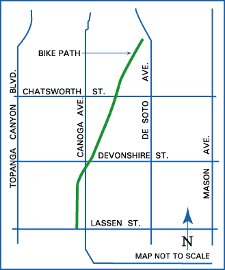
Browns Creek Bike Path is a Class I bike path in the San Fernando Valley, beginning at Lassen Street, just east of Chatsworth Metrolink Station, and ending north of Rinaldi Street near Stoney Point Park. [1]
Contents
Browns Creek is a tributary of the Los Angeles River, offering “splendid views of the irregularly shaped Santa Susana mountains rising to the west.” [2] One local writer observed, “What [the concrete-lined creek] lacks in scenery, it compensates for by providing the trail with an open, airy setting.” [3]
The wash passes through a neighborhood with equestrian zoning and “Opposite the bike route, in the west levee, a horse trail also follows the creek.” [2] Domestic goats, roosters and ponies have also been seen along the path. [3]
At Chatsworth station, bicyclists can connect to the G Line Bikeway. [1]
The path is in close proximity to Chatsworth Park North and Chatsworth Park South (both operated by the City of Los Angeles Parks Department) and Chatsworth Nature Preserve. [2] Both parks are accessible from Valley Circle Road. Riders can create an approximately 6.3-mile (10.1 km) loop beginning at either end of the Browns Creek route, connecting to Valley Circle Road via either Chatsworth Street or Lassen Street. [4]