
The Sepulveda Dam is a project of the U.S. Army Corps of Engineers designed to withhold winter flood waters along the Los Angeles River. Completed in 1941, at a cost of $6,650,561, it is located south of center in the San Fernando Valley, approximately eight miles east of the river's source in the western end of the Valley, in Los Angeles, California.

The Marvin Braude Bike Trail is a 22-mile (35 km) paved bicycle path that runs mostly along the shoreline of Santa Monica Bay in Los Angeles County, California. The coastal bike trail is widely acknowledged as Los Angeles’ “most popular bike path.”

The San Gabriel River Trail is a 28-mile (45 km) bike path along the San Gabriel River through El Dorado Regional Park and onto street bike trails near the Alamitos Bay Marina in Los Angeles County, California. The South end is Seal Beach. The northern segment begins near Whittier Narrows Recreation Area.

The Arroyo Seco Bicycle Path is an approximately 2-mile (3.2 km) long Class I bicycle path along the Arroyo Seco river channel and canyon in the Northeast Los Angeles region of Los Angeles County, California. It parallels the Arroyo Seco Parkway, which is also a part of the canyon.
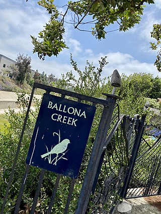
The Ballona Creek Bike Path is a 6.7-mile (10.8 km) Class I bicycle path and pedestrian route in California. The bike path follows the north bank of Ballona Creek until it reaches Santa Monica Bay at the Pacific Ocean. The route is defined by, and recognized for, the dramatic contrast between the channelized waterway’s stark cement geometry and the abundant wildlife of the verdant Ballona Wetlands.
The Imperial Highway is a west-east thoroughfare in the counties of Los Angeles, Orange, Riverside, San Diego, and Imperial in the U.S. state of California. The main portion of the existing route begins at Vista Del Mar in Los Angeles near the Los Angeles International Airport and ends at the Anaheim–Orange city line at Via Escola where it becomes Cannon Street. Historically, the Imperial Highway extended from Vista Del Mar to Calexico, where a portion of the highway still exists. The original route was replaced with other highways, leading the older portions of the Imperial Highway to fall out of use.
Ralph B. Clark Regional Park is an urban park located in the cities of Fullerton and Buena Park, California. The park is maintained by Orange County Regional Parks, the government division that controls the regional parks in Orange County. The park is south of Rosecrans Avenue at the southern edge of the West Coyote Hills in Buena Park, but both a small section named Camel Hill next to the main park area south of Rosecrans and another small section of the park with six softball fields and a trail located north of Rosecrans Avenue are within Fullerton city limits. The park was originally opened as Los Coyotes Regional Park in 1981, and was renamed in 1987 after then-retiring Orange County Supervisor Ralph B. Clark (1917–2009).

Harbor Boulevard is a north–south road corridor in the counties of Los Angeles and Orange. One of the busiest routes in Orange County, the thoroughfare passes through some of the most densely populated areas in the region and carries about 8 percent of the county's bus riders. The route provides access for local residents to travel to work and for drivers travelling from Valley Boulevard in the City of Industry via Fullerton Road to Newport Beach.
The Culver Boulevard Median Bike Path is Class I rail trail bicycle path, walk route and linear park on Culver Boulevard in western Los Angeles County, California.
Artesia Boulevard is a west-east thoroughfare in Los Angeles County and Orange County.

Coyote Creek is a principal tributary of the San Gabriel River in northwest Orange County, southeast Los Angeles County, and southwest Riverside County, California. It drains a land area of roughly 41.3 square miles (107 km2) covering eight major cities, including Brea, Buena Park, Fullerton, Hawaiian Gardens, La Habra, Lakewood, La Palma, and Long Beach. Some major tributaries of the creek in the highly urbanized watershed include Brea Creek, Fullerton Creek, and Carbon Creek. The mostly flat creek basin is separated by a series of low mountains, and is bounded by several small mountain ranges, including the Chino Hills, Puente Hills, and West Coyote Hills.

The Los Angeles River bicycle path is a Class I bicycle and pedestrian path in the Greater Los Angeles area running from north to east along the Los Angeles River through Griffith Park in an area known as the Glendale Narrows. The 7.4 mile section of bikeway through the Glendale Narrows is known as the Elysian Valley Bicycle & Pedestrian Path. The bike path also runs from the city of Vernon to Long Beach, California. This section is referred to as LARIO, or more formally, the Los Angeles River Bikeway.

Los Angeles River Bikeway, also known as LARIO, is a 29.1 mi (46.8 km) bikeway along the lower Los Angeles River in southern Los Angeles County, California. It is one of the completed sections of the Los Angeles River Bicycle Path planned to run along the entire 51 miles (82 km) length of the LA River.

The Expo Line Bikeway is a 12-mile (19 km) Los Angeles County, California rail with trail bicycle path and pedestrian route that travels roughly parallel to the Metro's E Line train tracks between the Exposition Park area near the USC campus and downtown Santa Monica near the Pacific Ocean. The Expo Line Bikeway is one of two major bicycle routes in Los Angeles that share dedicated rights-of-way with mass transit, the other being the Orange Line Bikeway in the San Fernando Valley.

The Tujunga Wash Greenway and Bike Path is a trail and stormwater mitigation project in the Valley Village and Valley Glen neighborhoods of California’s San Fernando Valley.
The Chandler Boulevard Bike Path is a Class I rail trail off-street bike route that runs from North Hollywood to Burbank in Los Angeles County, California.

The Orange Line Bikeway is a cycle route in Los Angeles County, California, that runs 17.9 miles (28.8 km) and “spans the lengths of the San Fernando Valley’s major communities” from Chatsworth to North Hollywood, “connecting such places as Pierce College, the Sepulveda Basin Recreation Area, the Van Nuys Government Center and Valley College.”


