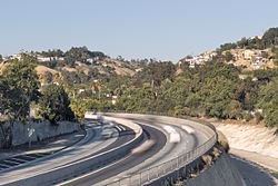
Montecito Heights, Los Angeles

Last updated
Montecito Heights
Montecito Heights from Pasadena Ave. 2015-04-12.jpg
Viewed from Pasadena Ave. bridge
Location map Los Angeles.png
Red pog.svg
Montecito Heights
Location within Central Los Angeles
Coordinates: 34°05′25″N118°12′10″W / 34.090258°N 118.202889°W / 34.090258; -118.202889
Country United States
State California
County Los Angeles
City Los Angeles
Time zone UTC-8 (PST)
  Summer (DST) UTC-7 (PDT)
ZIP code
90031

Montecito Heights is a neighborhood in the Northeast Los Angeles region of Los Angeles, California. The population in 2000 was estimated at 16,768.

Contents

Geography and transportation

Montecito Heights' boundaries are roughly the Pasadena Freeway (SR 110) or the Arroyo Seco on the northwest, Pasadena Avenue on the west, Avenue 35 to the south, Huntington Drive to the southeast, and Monterey Road to the east. Neighboring districts include Monterey Hills on the northeast, El Sereno on the southeast, Lincoln Heights on the southwest, Mount Washington on the northwest, and Highland Park on the north. Owing to the rugged terrain, no major thoroughfares run through the area, besides Griffin Avenue (Los Angeles). The district is largely in ZIP code 90031. Most of the homes on the hills were built after the 1950's when engineering technology enabled builders to construct on the steep hillsides.

Neighborhood

Annexed to the City of Los Angeles in 1912, Montecito Heights is known by the residents as the 'Wilderness in the City'. Montecito Heights sits on the Monterey Hills that divide the Los Angeles Basin from the San Gabriel Valley. Montecito Heights is a relatively isolated area of greenery and trendy resident home restorers.[ original research? ] City views are available on the district's hills.[ citation needed ] Along with neighboring Highland Park and Pasadena, it is one of the historic centers of the Arts and Crafts movement.[ citation needed ]

Landmarks

Notable residents

Related Research Articles

South Pasadena, California City in California in the United States

South Pasadena is a city in Los Angeles County, California, United States. As of the 2010 census, it had a population of 25,619, up from 24,292 at the 2000 census. It is located in the West San Gabriel Valley. It is 3.42 square miles in area and lies between the much larger city of Pasadena, of which it was once a part, and the metropolis of Los Angeles. South Pasadena is the oldest self-builder of floats in the historic Tournament of Roses Parade.

Mount Washington, Los Angeles Neighborhoods of Los Angeles in County of Los Angeles, California, United States

Mount Washington is a historic neighborhood in the San Rafael Hills of Northeast Los Angeles, California. Founded in 1909, it includes the Southwest Museum, the world headquarters of the Self-Realization Fellowship, and Eldred Street, one of the three steepest streets in Los Angeles.

Arroyo Seco Parkway Highway in California

The Arroyo Seco Parkway, also known as the Pasadena Freeway, is one of the oldest freeways built in the United States. It connects Los Angeles with Pasadena alongside the Arroyo Seco seasonal river. It is notable not only for being an early freeway, mostly opened in 1940, but for representing the transitional phase between early parkways and modern freeways. It conformed to modern standards when it was built, but is now regarded as a narrow, outdated roadway. A 1953 extension brought the south end to the Four Level Interchange in downtown Los Angeles and a connection with the rest of the freeway system.

Lincoln Heights, Los Angeles Neighborhood of Los Angeles in California, United States

Lincoln Heights is one of the oldest neighborhoods in Los Angeles, California, United States. It was originally called "East Los Angeles from 1873 to 1917. It is a densely populated neighborhood with a high percentage of Latino, Asian, Mexican and indigenous residents. It includes many historic landmarks and was known as "the Bedroom of the Pueblo".

Highland Park, Los Angeles Neighborhood of Los Angeles in California, United States

Highland Park is a neighborhood in northeast Los Angeles, California. It was one of the first subdivisions of Los Angeles and is inhabited by a variety of ethnic and socioeconomic groups.

Arroyo Seco (Los Angeles County) Seasonal watercourse and human settlement in USA

The Arroyo Seco, meaning "dry stream" in Spanish, is a 24.9-mile-long (40.1 km) seasonal river, canyon, watershed, and cultural area in Los Angeles County, California. The area was explored by Gaspar de Portolà who named the stream Arroyo Seco as this canyon had the least water of any he had seen. During this exploration he met the Chief Hahamog-na (Hahamonga) of the Tongva Indians.

Elysian Park, Los Angeles Neighborhood of Los Angeles in California, United States

Elysian Park is a neighborhood in Central Los Angeles, California. It is a predominantly low-income community, and has a population of more than 2,600 people. A city park, Elysian Park, and Dodger Stadium are within the neighborhood, as are an all-boys Catholic high school and an elementary school.

El Sereno, Los Angeles Neighborhood of Los Angeles in California, United States

El Sereno is a Los Angeles neighborhood in the Eastside Los Angeles region of Los Angeles County, California.

Monterey Hills, Los Angeles Neighborhood of Los Angeles in California, United States

Monterey Hills is a neighborhood in Los Angeles, California.

Arroyo Seco bicycle path

The Arroyo Seco Bicycle Path is an approximately 2 miles (3.2 km) long Class I bicycle path along the Arroyo Seco river channel in the Northeast Los Angeles region of Los Angeles County, California. It parallels to the Arroyo Seco Parkway also in the canyon.

Hermon, Los Angeles Neighborhood of Los Angeles in California, United States

Hermon is a neighborhood in the northeast area of Los Angeles. It was established in 1903 and became part of Los Angeles in 1912.

San Fernando Road major street in the City and County Los Angeles

San Fernando Road is a major street in the City of Los Angeles and Los Angeles County. Within the Burbank city limits it is signed as San Fernando Boulevard, and north of Newhall Pass it is signed as The Old Road. It was previously designated as Business Loop 5 in the 1970s.

Cypress Park, Los Angeles Neighborhood of Los Angeles

Cypress Park is a densely populated neighborhood of 10,000+ residents in Northeast Los Angeles, California. Surrounded by hills on three sides, it sits in the valley created by the Los Angeles River and the Arroyo Seco. It is the site of the Rio de Los Angeles State Park, the Los Angeles River Bike Path and other recreational facilities. It hosts one private and four public schools.

Heritage Square station Los Angeles Metro Rail station

Heritage Square is an at-grade light rail station on the L Line of the Los Angeles Metro Rail system. It is located at the intersection of French Avenue and Pasadena Avenue in the western Montecito Heights neighborhood of Los Angeles.

Garvanza, Los Angeles Neighborhood of Los Angeles in California, United States

Garvanza is a neighborhood in northeast Los Angeles bordered by Highland Park to the west, South Pasadena to the east, and Pasadena to the north. Seven Los Angeles Historic-Cultural Monuments are located in the neighborhood.

California Cycleway

The California Cycleway, opened in 1900, was a nine-mile (14 km) elevated tollway built specially for bicycle traffic through the Arroyo Seco, intended to connect the cities of Pasadena and Los Angeles, in California, United States.

The Los Angeles Avenues refer to a series of 50 numbered streets in Los Angeles, California in the Northeast and Eastside regions. They are all designated with the word "Avenue" followed by a number such as "Avenue 64." The Avenues are located in the Los Angeles neighborhoods of Lincoln Heights, Cypress Park, Montecito Heights, Glassell Park, Highland Park, Mt. Washington and Eagle Rock. They are not related to 2nd through 13th Avenues west of Arlington Avenue in Jefferson Park and other neighborhoods in South Los Angeles.

Northeast Los Angeles

Northeast Los Angeles is a 17.18 sq mi (44.5 km2) region of Los Angeles County, comprising seven neighborhoods within the City of Los Angeles. The area is home to Occidental College located in Eagle Rock.

Ernest E. Debs Regional Park


Ernest E. Debs Regional Park is a large open space nature reserve and regional park in the Montecito Hills neighborhood of central-northeast Los Angeles, California.

Lummis Day is a signature community arts and music event in the neighborhoods of Northeast Los Angeles, showcasing the community's considerable pool of musicians, poets, artists, dancers and restaurants representing a kaleidoscope of ethnicities and cultural traditions. Since 2014, Occidental College's Institute for the Study of Los Angeles has partnered with the Lummis Day Community Foundation to support cultural programming.

References

  1. "MEET BRICIA". Super Mamas. Retrieved 2 January 2020.

Coordinates: 34°05′25″N118°12′10″W / 34.090258°N 118.202889°W / 34.090258; -118.202889