University Hills, Los Angeles

Last updated
University Hills
UniversityHillsSignage2.jpg
University Hills Neighborhood sign
located at the intersection of
Valley Boulevard and Highbury Avenue
Location map Los Angeles.png
Red pog.svg
University Hills
Location within Central Los Angeles
Coordinates: 34°04′00″N118°10′04″W / 34.066667°N 118.167778°W / 34.066667; -118.167778
Country United States
State California
County Los Angeles
City Los Angeles
Time zone UTC-8 (PST)
  Summer (DST) UTC-7 (PDT)

University Hills is a neighborhood on the East Side of Los Angeles, California. It consists of the residential areas surrounding California State University, Los Angeles . [1]

Contents

History

University Hills is in the eastern San Rafael Hills. They were part of the Pre-columbian homeland of the Tongva Indians for thousands of years, and they named this area Otsunga (place of roses).

It is the former site of one of California's 36 original adobes, built in 1776 by Franciscan missionaries, and destroyed by a fire in 1908. The area was part of the 1831 Mexican land grant of Rancho Rosa Castilla, given to Juan Ballesteros by Alta California Governor Manuel Victoria. It was named for the abundant amount of native Wood roses (Rosa californica) along the creek. [2]

In 1852, after statehood, the title passed to Jean-Baptiste Batz and his wife, Catalina. He was a Basque immigrant rancher from northern Spain. In 1882, after both died, the land was divided among six of their children. [3] [4]

For most of its history, University Hills was a neighborhood within El Sereno, which was developed more than a century ago with the expansion of the Pacific Electric Railway Red Car lines. [5] In the 1990s, the community's homeowners association lobbied for renaming the area. In 2004, the City of Los Angeles designated the residential community surrounding California State University Los Angeles as "University Hills". [6] The increase in Southern California real estate values in the early 2000s attracted professionals looking for alternative neighborhoods to more distant suburbs and the Westside. [7]

Geography

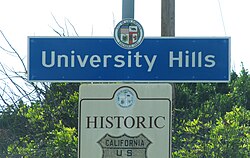
University Hills was designated an official Los Angeles neighborhood in October 2004. It is bounded by Mariana Avenue on the west, Valley Boulevard on the north, the Long Beach Freeway on the east, and Eastern Avenue on the south. The Department of Transportation was instructed to install signs (with a blue background, white text, and City logo at the top) at the following locations to identify "University Hills": Valley Boulevard at Beatie Place, Valley Boulevard at Highbury Avenue, and Eastern Avenue at Medford Street. [6]

University Hills is bordered by El Sereno on the north and west, City Terrace on the south, Alhambra on the north-east, and Monterey Park on the south-east.

Major thoroughfares include Eastern Avenue, Marianna Avenue, and Valley Boulevard. The San Bernardino freeway runs along the neighborhood's southern edge.

The adjacent campus of California State University, Los Angeles occupies nearly 200 acres (0.8 km2) on a hilltop site that affords views of the San Gabriel Mountains to the north, the San Gabriel Valley to the east, metropolitan Los Angeles to the west, and the Palos Verdes Peninsula and Catalina Island to the south.

University Hills sign at Lansdowne Avenue near Eastern Avenue University-Hills.png
University Hills sign at Lansdowne Avenue near Eastern Avenue

Education

University Hills is zoned to schools in the Los Angeles USD: [7]

Related Research Articles

Alhambra, California City in California

Alhambra is a city located in the western San Gabriel Valley region of Los Angeles County, California, United States, approximately eight miles from the Downtown Los Angeles civic center. It was incorporated on July 11, 1903. As of the 2020 census, the population was 82,868. The city's ZIP Codes are 91801 and 91803.

San Fernando Valley Large populated valley in Los Angeles County, California, US

The San Fernando Valley, known locally as the Valley, is an urbanized valley in Los Angeles County, California. Located just north of the Los Angeles Basin, it contains a large portion of the City of Los Angeles, as well as unincorporated areas and the incorporated cities of Burbank, Calabasas, Glendale, Hidden Hills, and San Fernando. The valley is well known for its iconic film studios such as Warner Bros. Studio and Walt Disney Studios. In addition, it is home to the Universal Studios Hollywood theme park. More recently, statewide droughts in California have further strained the San Fernando Valley’s and Los Angeles County’s water security.

<span class="mw-page-title-main">San Gabriel Valley</span> Populated valley in Southern California, United States

The San Gabriel Valley is one of the principal valleys of Southern California, lying generally to the east of the city of Los Angeles. Surrounding features include:

Interstate 710 and State Route 710 (California) Interstate and state highway in California

Route 710, consisting of the non-contiguous segments of State Route 710 (SR 710) and Interstate 710 (I-710), is a major north–south state highway and auxiliary Interstate Highway in the Los Angeles metropolitan area of the U.S. state of California. Also called the Los Angeles River Freeway prior to November 18, 1954, the highway was initially planned to connect Long Beach and Pasadena, but a gap in the route exists from Alhambra to Pasadena through South Pasadena due to community opposition to its construction.

West Hills, Los Angeles Neighborhood of Los Angeles in California, United States

West Hills is a suburban / residential community in the western San Fernando Valley region of the City of Los Angeles, California. The percentage of residents aged 35 and older is among the highest in Los Angeles County.

The Los Angeles Westside is an urban region in western Los Angeles County, California. It has no official definition, but sources like LA Weekly and the Mapping L.A. survey of the Los Angeles Times place the region on the western side of the Los Angeles Basin south of the Santa Monica Mountains.

North Hills, known previously as Sepulveda, is a neighborhood in the San Fernando Valley region of the City of Los Angeles.

California State Route 2 State highway in California, United States

State Route 2 (SR 2) is a state highway in the U.S. state of California. It connects the Los Angeles Basin with the San Gabriel Mountains and the Victor Valley in the Mojave Desert. The highway's southwestern end is at the intersection of Centinela Avenue at the Santa Monica-Los Angeles border and its northeastern end is at SR 138 east of Wrightwood. The SR 2 is divided into four segments, and it briefly runs concurrently with U.S. Route 101 (US 101) and Interstate 210 (I-210). The southwestern section of SR 2 runs along a segment of the east–west Santa Monica Boulevard, an old routing of US 66, to US 101 in East Hollywood; the second section runs along segments of both the north–south Alvarado Street and Glendale Boulevard in Echo Park; the third section to I-210 in Glendale is known as the north–south Glendale Freeway; and the northeastern portion from I-210 in La Cañada Flintridge to SR 138 is designated as the Angeles Crest Highway.

California State Route 118 Highway in California

State Route 118 is a state highway in the U.S. state of California that runs west to east through Ventura and Los Angeles counties. It travels from State Route 126 at the eastern edge of Ventura immediately northwest of Saticoy, then through Saticoy, in Ventura County east to Interstate 210 near Lake View Terrace in Los Angeles. SR 118 crosses the Santa Susana Pass and the northern rim of the San Fernando Valley along its route.

Lake View Terrace, Los Angeles Neighborhood of Los Angeles in California, United States

Lake View Terrace is a suburban neighborhood in the San Fernando Valley region of the City of Los Angeles, California.

East Hollywood, Los Angeles Neighborhood of Los Angeles in California, United States

East Hollywood is a densely populated neighborhood of 78,000+ residents in the central region of Los Angeles, California. It is notable for being the site of Los Angeles City College, Barnsdall Park and a hospital district. There are seven public and five private schools, as well as a branch of the Los Angeles Public Library and three hospitals. Almost two-thirds of the people living there were born outside the United States and 90% were renters. In 2000 the neighborhood had high percentages of never-married people and of single parents.

El Sereno, Los Angeles Neighborhood of Los Angeles in California, United States

El Sereno is a Los Angeles neighborhood in the Eastside Los Angeles region of Los Angeles County, California.

Montecito Heights, Los Angeles Neighborhood of Los Angeles in California, United States

Montecito Heights is a neighborhood in the Northeast Los Angeles region of Los Angeles, California. The population in 2000 was estimated at 16,768.

Santa Monica Boulevard Major west-east thoroughfare in Los Angeles County, California, USA

Santa Monica Boulevard is a major west–east thoroughfare in Los Angeles County. It runs from Ocean Avenue in Santa Monica near the Pacific Ocean to Sunset Boulevard at Sunset Junction in Los Angeles. It passes through Beverly Hills and West Hollywood. A portion of it is designated as California State Route 2.

Western Avenue (Los Angeles) Street in Los Angeles County, California

Western Avenue is a major four-lane street in the city of Los Angeles and through the center portion of Los Angeles County, California. It is one of the longest north–south streets in Los Angeles city and county, apart from Sepulveda Boulevard. It is about 29 miles (47 km) long.

Vermont Avenue Major thoroughfare in Los Angeles, CA

Vermont Avenue is one of the longest running north–south streets in City of Los Angeles and Los Angeles County, California. With a length of 23.3 miles (37.5 km), is the third longest of the north–south thoroughfares in the region. For most of its length between its southern end in San Pedro and south of Downtown Los Angeles, it runs parallel to the west of the Harbor Freeway (I-110).

San Fernando Road Major street in the City and County Los Angeles

San Fernando Road is a major street in the City of Los Angeles and Los Angeles County. Within the Burbank city limits it is signed as San Fernando Boulevard, and north of Newhall Pass it is signed as The Old Road. It was previously designated as Business Loop 5 in the 1970s.

Foothill Boulevard is a major road in the city and county of Los Angeles, as well as an arterial road in the city and county of San Bernardino, stretching well over 60 miles (97 km) in length, with some notable breaks along the route. Like its name implies, Foothill Boulevard runs across the foothills of the San Gabriel and San Bernardino Mountains.

Beverly Drive

Beverly Drive is a major north–south roadway in Beverly Hills and Los Angeles.

Los Angeles City Council District 14 American legislative district

Los Angeles City Council District 14 is one of the 15 districts of the Los Angeles City Council. The district, which has a large Latin American population, includes the neighborhoods of Boyle Heights, Downtown Los Angeles and parts of Northeast Los Angeles. Councilman Kevin de León has represented the district since 2020. He replaced José Huizar after winning outright in the special election held during the 2020 California primaries; he was officially appointed on October 15, 2020. Huizar had vacated the seat earlier in the year due to bribery and corruption allegations.

References

  1. "Council File 04-0944 Designating University Hills" (PDF). November 1, 2004. p. 2. Retrieved 10 March 2021. University Hills...which is comprised of the residential areas surrounding the California State University Los Angeles campus.
  2. J. N. Bowman, The Rose of Castile, Western Folklore, Vol. 6, No. 3 (Jul., 1947), pp. 204–210, Western States Folklore Society
  3. John R. Chávez, 1998, Eastside Landmark:A History of the East Los Angeles Community Union, 1968-1993, ISBN   978-0-8047-3333-5, Stanford University Press
  4. "Sustainable Cities and Industrial Ecology in El Sereno" (PDF). Archived from the original (PDF) on 2008-05-24. Retrieved 2009-02-24.
  5. The Eastsider.com: "El Sereno historic district comes up for review"
  6. 1 2 "Council File No. 04-0944 - "Designating University Hills"" (PDF). October 12, 2004. Retrieved 9 March 2021.
  7. 1 2 Jennifer Delson, "A Campus Enclave That's a Study in Contrasts," Los Angeles Times, April 24, 2005

Coordinates: 34°04′00″N118°10′04″W / 34.06667°N 118.16778°W / 34.06667; -118.16778