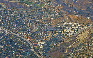
La Cañada Flintridge, commonly known as just La Cañada, is a city in the foothills of the Verdugo Mountains in Los Angeles County, California, United States. Located in the Crescenta Valley, in the western edge of the San Gabriel Valley, it is the location of NASA's Jet Propulsion Laboratory.

The San Gabriel Mountains comprise a mountain range located in northern Los Angeles County and western San Bernardino County, California, United States. The mountain range is part of the Transverse Ranges and lies between the Los Angeles Basin and the Mojave Desert, with Interstate 5 to the west and Interstate 15 to the east. The range lies in, and is surrounded by, the Angeles and San Bernardino National Forests, with the San Andreas Fault as its northern border.

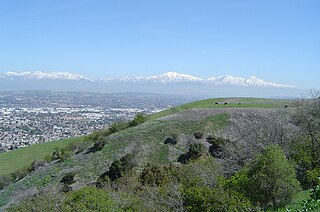
The San Gabriel Valley, often referred to by its initials as SGV, is one of the principal valleys of Southern California, with the city of Los Angeles directly bordering it to the west, and occupying the vast majority of the southeastern part of Los Angeles County. Surrounding landforms and other features include the following:

State Route 2 (SR 2) is a state highway in the U.S. state of California. It connects the Los Angeles Basin with the San Gabriel Mountains and the Victor Valley in the Mojave Desert. The highway's southwestern end is at the intersection of Centinela Avenue at the Santa Monica-Los Angeles border and its northeastern end is at SR 138 east of Wrightwood. The SR 2 is divided into four segments, and it briefly runs concurrently with U.S. Route 101 (US 101) and Interstate 210 (I-210). The southwestern section of SR 2 runs along a segment of the east–west Santa Monica Boulevard, an old routing of US 66, to US 101 in East Hollywood; the second section runs along segments of both the north–south Alvarado Street and Glendale Boulevard in Echo Park; the third section to I-210 in Glendale is known as the north–south Glendale Freeway; and the northeastern portion from I-210 in La Cañada Flintridge to SR 138 is designated as the Angeles Crest Highway.

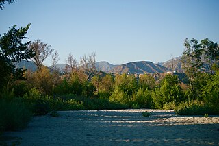
The San Gabriel River is a mostly-urban waterway flowing 58 miles (93 km) southward through Los Angeles and Orange Counties, California, in the United States. It is the central of three major rivers draining the Greater Los Angeles Area, the others being the Los Angeles River and Santa Ana River. The river's watershed stretches from the rugged San Gabriel Mountains to the heavily-developed San Gabriel Valley and a significant part of the Los Angeles coastal plain, emptying into the Pacific Ocean between the cities of Long Beach and Seal Beach.

The Arroyo Seco, meaning "dry stream" in Spanish, is a 24.9-mile-long (40.1 km) seasonal river, canyon, watershed, and cultural area in Los Angeles County, California. The area was explored by Gaspar de Portolà who named the stream Arroyo Seco as this canyon had the least water of any he had seen. During this exploration he met the Chief Hahamog-na (Hahamonga) of the Tongva Indians.

The Puente Hills are a chain of hills, one of the lower Transverse Ranges, in an unincorporated area in eastern Los Angeles County, California, in the United States. The western end of the range is often referred to locally as the Whittier Hills. The eastern end is in the city of Chino Hills in San Bernardino County.

The Crescenta Valley is a small inland valley in Los Angeles County, California, lying between the San Gabriel Mountains on the northeast and the Verdugo Mountains and San Rafael Hills on the southwest. It opens into the San Fernando Valley at the northwest and the San Gabriel Valley at the southeast. It is nearly bisected by the Verdugo Wash, a smaller valley separating the Verdugo Mountains from the San Rafael Hills. Most of the valley lies at an elevation of over 1,500 feet.

The Verdugo Mountains, also known as the Verdugo Hills or simply The Verdugos, are a small, rugged mountain range of the Transverse Ranges system in Los Angeles County, California. Located just south of the western San Gabriel Mountains, the Verdugo Mountains region incorporates the cities of Burbank, Glendale, Pasadena, and La Cañada Flintridge; the unincorporated communities of Altadena and La Crescenta-Montrose; as well as the City of Los Angeles neighborhood of Sunland-Tujunga. It is where the borders of the San Gabriel Valley and the San Fernando Valley meet.

The Whittier Narrows is a narrows or water gap in the San Gabriel Valley of Los Angeles County, California, United States, between the Puente Hills to the east and the Montebello Hills to the west. The gap is located at the southern boundary of the San Gabriel Valley, through which the Rio Hondo and the San Gabriel River flow to enter the Los Angeles Basin. The Narrows is located near the convergence of Interstate 605 and California State Route 60.
The Hahamog'na, commonly anglicized to Hahamongna and spelled Xaxaamonga in their native language, are a tribe of the Tongva people of California. Their language belongs to the Uto-Aztecan family.

California's 28th congressional district is a congressional district in the U.S. state of California, in Los Angeles County. The district is regarded as a Democratic stronghold and has been held by the Democratic Party since 2003 and is currently represented by Democrat Judy Chu.
Rancho La Cañada was a 5,832-acre (23.60 km2) Mexican land grant in the San Rafael Hills and Crescenta Valley, of present-day Los Angeles County, California, given in 1843 by Governor Manuel Micheltorena to a Mexican schoolteacher from Los Angeles, Ygnacio Coronel.

Rancho San Rafael was a 36,403-acre (147.32 km2) Spanish land grant in the San Rafael Hills, bordering the Los Angeles River and the Arroyo Seco in present-day Los Angeles County, southern California, given in 1784 to Jose Maria Verdugo.
The Southern California Association of Governments (SCAG) is the metropolitan planning organization (MPO) of six of the ten counties in Southern California, serving Imperial County, Los Angeles County, Orange County, Riverside County, San Bernardino County, and Ventura County. San Diego County's MPO is the San Diego Association of Governments, which is an unrelated agency.

Northeast Los Angeles is a 17.18 sq mi (44.5 km2) region of Los Angeles County, comprising seven neighborhoods within Los Angeles. The area is home to Occidental College located in Eagle Rock.
José María Verdugo was a soldier from the Presidio of San Diego who was assigned to the Mission San Gabriel Arcángel at the time his land was granted by the Spanish Empire in 1784.

Hahamongna and Hahamog-na are two historic Tongva village sites. They are located in the Verdugo Mountains of Southern California and bear the name of the local band of indigenous Tongva, "Hahamog'na." The sites are located in present-day Pasadena and Glendale in Los Angeles County, California. Hahamongna was one of the largest Tongva villages in the greater San Fernando Valley area, along with Cahuenga, Tujunga, and Siutcanga.

Casa Adobe de San Rafael is one of the oldest homes in Glendale, California. The home has been in continuous use since its founding in 1865. It was designated a California Historic Landmark on October 31, 1935.


