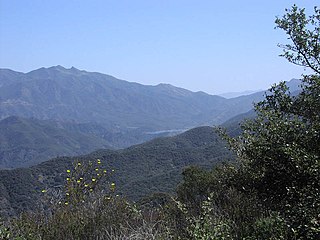
The Santa Monica Mountains is a coastal mountain range in Southern California, paralleling the Pacific Ocean. It is part of the Transverse Ranges. Because of its proximity to densely populated regions, it is one of the most visited natural areas in California. Santa Monica Mountains National Recreation Area is located in this mountain range.
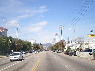
Reseda Boulevard, originally named Reseda Avenue until May 1929, is a major north-south arterial road that runs through the western San Fernando Valley of Los Angeles County, California.
Marvin Braude (1920–2005) was a member of the Los Angeles City Council for 32 years, between 1965 and 1997—the third-longest-serving council member in the history of the city. He was known for protecting the open space of the Santa Monica Mountains and successfully pushing the city to ban smoking in restaurants and government buildings.
The California coastal sage and chaparral, a sub-ecoregion of the California chaparral and woodlands ecoregion, is found in southwestern California and northwestern Baja California in Mexico.
The California chaparral and woodlands is a terrestrial ecoregion of lower northern, central, and southern California and northwestern Baja California (Mexico), located on the west coast of North America. It is an ecoregion of the Mediterranean forests, woodlands, and scrub Biome, and part of the Nearctic ecozone.
An ecoregion is an ecologically and geographically defined area that is smaller than a bioregion, which in turn is smaller than an ecozone. All three of these are either less or greater than an ecosystem. Ecoregions cover relatively large areas of land or water, and contain characteristic, geographically distinct assemblages of natural communities and species. The biodiversity of flora, fauna and ecosystems that characterise an ecoregion tends to be distinct from that of other ecoregions. In theory, biodiversity or conservation ecoregions are relatively large areas of land or water where the probability of encountering different species and communities at any given point remains relatively constant, within an acceptable range of variation.
Trails
Mountain Bikers at Southern Terminus of Reseda Drive
Braude Park connects with 11,000-acre (45km2)Topanga State Park and the 20,000-acre (81km2) "Big Wild" to create a large expanse of undeveloped wild land offering hiking, mountain biking and equestrian trails.
Topanga State Park is a California state park located in the Santa Monica Mountains, within Los Angeles County, California. It is part of the Santa Monica Mountains National Recreation Area.
Mountain biking is a sport of riding bicycles off-road, often over rough terrain, using specially designed mountain bikes. Mountain bikes share similarities with other bikes but incorporate features designed to enhance durability and performance in rough terrain. Mountain biking can generally be broken down into multiple categories: cross country, trail riding, all mountain, downhill, freeride and dirt jumping.
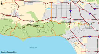
Mulholland Drive is a street and road in the eastern Santa Monica Mountains of Southern California. It is named after pioneering Los Angeles civil engineer William Mulholland. The western rural portion in Los Angeles and Ventura Counties is named Mulholland Highway. The road is featured in a significant number of movies, songs, and novels. David Lynch, who wrote and directed a film named after Mulholland Drive, has said that one can feel "the history of Hollywood" on it.
The Los Angeles Basin is a sedimentary basin located in southern California, in a region known as the Peninsular Ranges. The basin is also connected to an anomalous group of east-west trending chains of mountains collectively known as the California Transverse Ranges. The present basin is a coastal lowland area, whose floor is marked by elongate low ridges and groups of hills that is located on the edge of the Pacific plate. The Los Angeles Basin, along with the Santa Barbara Channel, the Ventura Basin, the San Fernando Valley, and the San Gabriel Basin, lies within the greater southern California region. On the north, northeast, and east, the lowland basin is bound by the Santa Monica Mountains and Puente, Elysian, Repetto hills. To the southeast, the basin is bordered by the Santa Ana mountains and the San Joaquin Hills. The western boundary of the basin is marked by the Continental Borderland and is part of the onshore portion. The California borderland is characterized by north-west trending offshore ridges and basins. The Los Angeles Basin is notable for its great structural relief and complexity in relation to its geologic youth and small size for its prolific oil production. Yerkes et al. identify 5 major stages of the basin's evolution that begins in the Upper Cretaceous and ends in the Pleistocene. This basin can be classified as an irregular pull-apart basin accompanied by rotational tectonics during the post-early Miocene.
The Pacific Ocean is the largest and deepest of Earth's oceanic divisions. It extends from the Arctic Ocean in the north to the Southern Ocean in the south and is bounded by Asia and Australia in the west and the Americas in the east.
The park trails also connects with the Backbone Trail System that runs along the length of the range.
Braude Park is also the unofficial trail head for the Lemming Trail, a 10-mile (16km) one-way hike over the mountains from the valley to the sea. Lemming Trail offers a grand tour of the Santa Monica Mountains, from Tarzana to Topanga to Temescal to the Pacific.
Access
The entrance to the park is located 3.2 miles (5.1km) south of the Ventura Freeway on Reseda Boulevard up in the mountains.
The Ventura Freeway is a freeway in southern California, United States, running from the Santa Barbara/Ventura county line to Pasadena in Los Angeles County. It is the principal east-west route through Ventura County and in the southern San Fernando Valley in Los Angeles County. From the Santa Barbara County line to its intersection with the Hollywood Freeway in the southeastern San Fernando Valley in Los Angeles, it is signed as U.S. Route 101, which was built in the late 1950s and opened on April 5, 1960. East of the Hollywood Freeway intersection, it is signed as State Route 134 which was built by 1971. The entire Ventura Freeway is not built to freeway standards, however; the segment that runs through the coastal communities of La Conchita and Mussel Shoals in western Ventura County still remains an expressway.
This page is based on this Wikipedia article Text is available under the CC BY-SA 4.0 license; additional terms may apply. Images, videos and audio are available under their respective licenses.
Related Research Articles
The San Fernando Valley is an urbanized valley in Los Angeles County, California in the Los Angeles metropolitan area, defined by the mountains of the Transverse Ranges circling it. Home to 1.77 million people, it is north of the larger, more populous Los Angeles Basin.
Tarzana is a neighborhood in the San Fernando Valley region of the city of Los Angeles, California. Tarzana is on the site of a former ranch owned by author Edgar Rice Burroughs. It is named after Burroughs' fictional jungle hero, Tarzan.
The Santa Monica Mountains Conservancy is an agency of the state of California in the United States founded in 1980 and dedicated to the acquisition of land for preservation as open space, for wildlife and California native plants habitat Nature Preserves, and for public recreation activities.
Topanga is a census-designated place (CDP) in western Los Angeles County, California, United States. Located in the Santa Monica Mountains, the community lies in Topanga Canyon. The narrow southern portion of Topanga at the coast is in between the city of Malibu and the city of Los Angeles neighborhood of Pacific Palisades. Topanga had a population of 11,101 as of 2019. The ZIP code is 90290 and the area code is primarily 310, with 818 only at the north end of the canyon. It is in the 3rd County Supervisorial district.
Mulholland Highway is a scenic road in Los Angeles County, California, that runs approximately 50 miles through the western Santa Monica Mountains from near US Route 101 in Calabasas to Highway 1 near Malibu at Leo Carrillo State Park and the Pacific Ocean coast - at the border of Los Angeles and Ventura Counties.
The Upper Las Virgenes Canyon Open Space Preserve is a large open space nature preserve owned and operated by the Santa Monica Mountains Conservancy spanning nearly 3,000 acres (1,200 ha) in the Simi Hills of western Los Angeles County and eastern Ventura County.
The Santa Monica Mountains National Recreation Area is a United States National Recreation Area containing many individual parks and open space preserves, located primarily in the Santa Monica Mountains of Southern California. The SMMNRA is located within the greater Los Angeles region, with two thirds of the parklands in northwest Los Angeles County, and the remaining third, including a Simi Hills extension, in southeastern Ventura County.
The Backbone Trail is a long distance trail extending 67.79 miles (109.10 km) across the length of the Santa Monica Mountains in the U.S. state of California. Its western terminus is Point Mugu State Park and its eastern terminus is Will Rogers State Historic Park in Pacific Palisades. The trail is open to hikers throughout its length; dogs, mountain bicyclists and horseback riders are allowed on portions of the trail as posted.
Victory Boulevard is a major east-west arterial road that runs 25 miles (40 km) traversing the entire length of the San Fernando Valley in Los Angeles County, Southern California.
Los Angeles City Council District 11 is one of the 15 districts of the Los Angeles City Council, representing the Westside of the city to the Pacific Ocean. Mike Bonin is the district's current representative on the City Council.
Arroyo Calabasas is a 7.0-mile-long (11.3 km) tributary of the Los Angeles River, in the southwestern San Fernando Valley area of Los Angeles County in California.
Los Angeles City Council District 3 is one of the 15 districts of the Los Angeles City Council. It covers some of the westernmost areas of Los Angeles, in the southwestern San Fernando Valley. Its current representative is Councilmember Bob Blumenfield, who took office on 1 July 2013. The preceding representative was Dennis Zine.
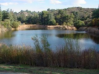
Franklin Canyon Park is a public park located near Benedict Canyon at the eastern end of the Santa Monica Mountains. The park comprises 605 acres (2.45 km2), and is located at the purported geographical center of the city of Los Angeles. The park features a 3-acre (12,000 m2) lake, a duck pond and over five miles (8 km) of hiking trails.
Circle X Ranch is a park unit located in the Triunfo Pass within the southwestern Santa Monica Mountains National Recreation Area — SMMNRA, in Ventura County, California. It is located in the western Santa Monica Mountains.
Sage Ranch Park is a 625-acre park (253 ha) and wildlife corridor located at a 2,000 feet (610 m) height in the northwestern Simi Hills on the northwestern plateau of the Simi Valley, bordering Los Angeles County and its San Fernando Valley. The campground area used to be a cattle ranch and later a filmset for Western movies. Sage Ranch Park is today an intermountain wildlife corridor, which links the Simi Hills with the Santa Susana- and Santa Monica Mountains. The mountainous park is mostly known for its unique sandstone rock formations, maybe particularly on its western side where the Sandstone Ridge and Turtle Rock are situated. On its northern side, there are great panoramic rural and metropolitan views of the Simi Valley, as well as surrounding Simi Hills, Santa Susana Mountains and beyond. It is home to numerous sandstone formations, caves, outcroppings, tilted rock formations, several hiking trails, a camping ground, as well as native flora and wildlife. The area is lined with coastal sage scrub and other flora includes chaparral, bush lupine, California poppy, sunflowers, Cream Cups, bracken, sword fern, prickly pear cactus, eucalyptus trees, oak woodland of ceanothus, coffee berry, California buckwheat, sycamore, Walnut Tree, ferns, orange- and avocado trees. It is a critical cross-mountain wildlife corridor and is home to fauna such as mountain lions, bobcats, eagles, vultures, owls, rattle snakes, coyotes, hawks, grey fox, king snakes, and more. Bordering Sage Ranch to the south is the Rocketdyne Santa Susana Field Laboratory, in which the nearby Burro Flats Painted Cave is located.