California chaparral and woodlands

Last updated
California chaparral and woodlands
Los Padres S.jpg
Ecology
Realm Nearctic
Biome Mediterranean forests, woodlands, and scrub
Geography
Area121,000 km2 (47,000 sq mi)
Countries
  • United States
  • Mexico
States
Climate type Mediterranean

The California chaparral and woodlands is a terrestrial ecoregion of southwestern Oregon, northern, central, and southern California (United States) and northwestern Baja California (Mexico), located on the west coast of North America. It is an ecoregion of the Mediterranean forests, woodlands, and scrub biome, and part of the Nearctic realm.

Contents

Setting

Three sub-ecoregions

The California chaparral and woodlands ecoregion is subdivided into three smaller ecoregions. [1]

Locations

Montane chaparral and woodlands in the Santa Ynez Mountains, near Santa Barbara, California Chaparral1.jpg
Montane chaparral and woodlands in the Santa Ynez Mountains, near Santa Barbara, California

Most of the population of California and Baja California lives in these ecoregions, which includes the San Francisco Bay Area, Ventura County, the Greater Los Angeles Area, San Diego County, Tijuana, and Ensenada, Baja California.

The California Central Valley grasslands ecoregion, as well as the coniferous Sierra Nevada forests, Northern California coastal forests, and Klamath-Siskiyou forests of northern California and southwestern Oregon, share many plant and animal affinities with the California chaparral and woodlands. Many botanists consider the California chaparral and woodlands, Sierra Nevada forests, Klamath-Siskiyou forests, and Northern California coastal forests as a single California Floristic Province, excluding the deserts of eastern California, which belong to other floristic provinces. Many Bioregionalists, including poet Gary Snyder, identify the central and northern Coast Ranges, Klamath-Siskiyou, the Central Valley, and Sierra Nevada as the Shasta Bioregion or the Alta California Bioregion.

Southern coastal sage and chaparral in the Santa Monica Mountains, near Malibu. Santa monica mountains canyon.jpg
Southern coastal sage and chaparral in the Santa Monica Mountains, near Malibu.

Flora

The ecoregion includes a great variety of plant communities, including grasslands, oak savannas and woodlands, chaparral, and coniferous forests, including southern stands of the tall coast redwood (Sequoia sempervirens). The flora of this ecoregion also includes tree species such as gray or foothill pine (Pinus sabiniana), scrub oak (Quercus dumosa), California buckeye (Aesculus californica), the rare Gowen cypress (Cupressus goveniana), the rare Monterey cypress (Cupressus macrocarpa), and a wealth of endemic plant species, including the extremely rare San Gabriel Mountain liveforever (Dudleya densiflora), Catalina mahogany (Cercocarpus traskiae), and the threatened most beautiful jewel-flower (Streptanthus albidus ssp. Peramoenus). [1] Hesperoyucca whipplei , colloquially known as Chaparral Yucca, is commonplace throughout the lower elevations of the climate zone.

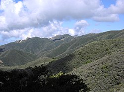
There are two types of chaparral: soft and hard chaparral. Hard chaparral is usually evergreen, located at higher elevation and is harder to walk through. Soft chaparral tends to be drought deciduous, live at lower elevations and tends to be easier to walk through.[ citation needed ]

Fauna

Species include the California gnatcatcher (Polioptila californica), Costa's hummingbird (Calypte costae), coast horned lizard (Phrynosoma coronatum), and rosy boa (Lichanura trivirgata). Other animals found here are the Heermann kangaroo rat (Dipodomys heermanni), Santa Cruz kangaroo rat (Dipodomys venustus), and the endangered white-eared pocket mouse (Perognathus alticolus). [1]

Another notable insect resident of this ecoregion is the rain beetle (Pleocoma sp.) It spends up to several years living underground in a larval stage and emerges only during wet-season rains to mate.

Fire

Chaparral, like most Mediterranean shrublands, is highly fire resilient and historically burned with high-severity, stand replacing events every 30 to 100 years. [2] Historically, Native Americans burned chaparral to promote grasslands for textiles and food. [3] Though adapted to infrequent fires, chaparral plant communities can be exterminated by frequent fires especially with climate change induced drought. [4] [5] Today, frequent accidental ignitions can convert chaparral from a native shrubland to nonnative annual grassland and drastically reduce species diversity, especially under global-change-type drought. [4] [5] The historical fire return interval for chaparral communities used to be 30–50 years, but has now decreased to 5–10 years due to human interference.[ citation needed ]

Human influence

California oak woodlands, in Gaviota State Park, near Santa Barbara, California Gaviota sp2.jpg
California oak woodlands, in Gaviota State Park, near Santa Barbara, California

The region has been heavily affected by grazing, logging, dams and water diversions, and intensive agriculture and urbanization, as well as competition by numerous introduced or exotic plant and animal species. Some unique plant communities, like southern California's Coastal Sage Scrub, have been nearly eradicated by agriculture and urbanization. As a result, the region now has many rare and endangered species, including the California condor (Gymnogyps californianus).[ citation needed ]

See also

Related Research Articles

<span class="mw-page-title-main">Chaparral</span> Shrubland plant community in western North America

Chaparral is a shrubland plant community found primarily in California, in southern Oregon and in the northern portion of the Baja California Peninsula in Mexico. It is shaped by a Mediterranean climate and infrequent, high-intensity crown fires.

The Global 200 is the list of ecoregions identified by the World Wide Fund for Nature (WWF), the global conservation organization, as priorities for conservation. According to WWF, an ecoregion is defined as a "relatively large unit of land or water containing a characteristic set of natural communities that share a large majority of their species dynamics, and environmental conditions". For example, based on their levels of endemism, Madagascar gets multiple listings, ancient Lake Baikal gets one, and the North American Great Lakes get none.

<span class="mw-page-title-main">Pacific Coast Ranges</span> Series of mountain ranges along the Pacific coast of North America

The Pacific Coast Ranges are the series of mountain ranges that stretch along the West Coast of North America from Alaska south to Northern and Central Mexico. Although they are commonly thought to be the westernmost mountain range of the continental United States and Canada, the geologically distinct Insular Mountains of Vancouver Island lie farther west.

<span class="mw-page-title-main">Ecology of California</span> Environments and natural history of California

The ecology of California can be understood by dividing the state into a number of ecoregions, which contain distinct ecological communities of plants and animals in a contiguous region. The ecoregions of California can be grouped into four major groups: desert ecoregions, Mediterranean ecoregions, forested mountains, and coastal forests.

<span class="mw-page-title-main">Ecology of the Sierra Nevada</span> Ecological features of the Sierra Nevadas

The ecology of the Sierra Nevada, located in the U.S. states of California and Nevada, is diverse and complex. The combination of climate, topography, moisture, and soils influences the distribution of ecological communities across an elevation gradient from 500 to 14,500 feet. Biotic zones range from scrub and chaparral communities at lower elevations, to subalpine forests and alpine meadows at the higher elevations. Particular ecoregions that follow elevation contours are often described as a series of belts that follow the length of the Sierra Nevada. There are many hiking trails, paved and unpaved roads, and vast public lands in the Sierra Nevada for exploring the many different biomes and ecosystems.

<span class="mw-page-title-main">Madrean pine–oak woodlands</span>

The Madrean pine–oak woodlands are subtropical woodlands found in the mountains of Mexico and the southwestern United States. They are a biogeographic region of the tropical and subtropical coniferous forests and temperate broadleaf and mixed forests biomes, located in North America.

<span class="mw-page-title-main">Northern California coastal forests</span> Temperate coniferous forests ecoregion in northern California and southwestern Oregon

The Northern California coastal forests are a temperate coniferous forests ecoregion of coastal Northern California and southwestern Oregon.

<span class="mw-page-title-main">Coastal sage scrub</span> Shrubland plant community of California

Coastal sage scrub, also known as coastal scrub, CSS, or soft chaparral, is a low scrubland plant community of the California coastal sage and chaparral subecoregion, found in coastal California and northwestern coastal Baja California. It is within the California chaparral and woodlands ecoregion, of the Mediterranean forests, woodlands, and scrub biome.

<span class="mw-page-title-main">California mixed evergreen forest</span>

California mixed evergreen forest is a plant community found in the mountain ranges of California and southwestern Oregon.

<span class="mw-page-title-main">California Coast Ranges</span> Mountain range

The Coast Ranges of California span 400 miles (644 km) from Del Norte or Humboldt County, California, south to Santa Barbara County. The other three coastal California mountain ranges are the Transverse Ranges, Peninsular Ranges and the Klamath Mountains.

<span class="mw-page-title-main">California Floristic Province</span> Region of uniform plant variety in the western United States and Mexico

The California Floristic Province (CFP) is a floristic province with a Mediterranean-type climate located on the Pacific Coast of North America with a distinctive flora similar to other regions with a winter rainfall and summer drought climate like the Mediterranean Basin. This biodiversity hotspot is known for being the home of the Sierran giant sequoia tree and its close relative the coast redwood. In 1996, the Province was designated as a biodiversity hotspot allowing it to join ranks among 33 other areas in the world with many endemic species. To be named a biodiversity hotspot, an area has to contain species and plant life that cannot be found anywhere else in the world. The California Floristic Province is home to over 3,000 species of vascular plants, 60% of which are endemic to the province.

<i>Baccharis pilularis</i> Species of shrub

Baccharis pilularis, called coyote brush, chaparral broom, and bush baccharis, is a shrub in the family Asteraceae native to California, Oregon, Washington, and Baja California. There are reports of isolated populations in New Mexico, most likely introduced.

<i>Ephedra californica</i> Species of seed-bearing shrub

Ephedra californica is a species of Ephedra, known by the common names California jointfir, California ephedra, desert tea, Mormon tea, and cañatillo.

<span class="mw-page-title-main">Klamath Mountains (ecoregion)</span> Temperate coniferous forests ecoregion in northern California and southwestern Oregon

The Klamath Mountains ecoregion of Oregon and California lies inland and north of the Coast Range ecoregion, extending from the Umpqua River in the north to the Sacramento Valley in the south. It encompasses the highly dissected ridges, foothills, and valleys of the Klamath and Siskiyou Mountains. It corresponds to the Level III ecoregion designated by the Environmental Protection Agency and to the Klamath-Siskiyou forests ecoregion designated by the World Wide Fund for Nature.

<i>Ophioglossum californicum</i> Species of fern in the family Ophioglossaceae

Ophioglossum californicum, known by the common name California adder's tongue, is an uncommon species of fern in the family Ophioglossaceae.

<span class="mw-page-title-main">California coastal sage and chaparral</span> Mediterranean forests, woodlands, and scrub ecoregion in Mexico and the United States

The California coastal sage and chaparral is a Mediterranean forests, woodlands, and scrub ecoregion, defined by the World Wildlife Fund, located in southwestern California and northwestern Baja California (Mexico). It is part of the larger California chaparral and woodlands ecoregion. The ecoregion corresponds to the USDA Southern California ecoregion section 261B, and to the EPA Southern California/Northern Baja Coast ecoregion 8.

<span class="mw-page-title-main">California interior chaparral and woodlands</span> Mediterranean forests, woodlands, and scrub ecoregion in California, United States

The California interior chaparral and woodlands ecoregion covers 24,900 square miles (64,000 km2) in an elliptical ring around the California Central Valley. It occurs on hills and mountains ranging from 300 feet (91 m) to 3,000 feet (910 m). It is part of the Mediterranean forests, woodlands, and scrub biome, with cool, wet winters and hot, dry summers. Temperatures within the coast can range from 53° to 65 °F and 32° to 60 °F within the mountains. Many plant and animal species in this ecoregion are adapted to periodic fire.

<span class="mw-page-title-main">Mediterranean forests, woodlands, and scrub</span> Habitat defined by the World Wide Fund for Nature

Mediterranean forests, woodlands and scrub is a biome defined by the World Wide Fund for Nature. The biome is generally characterized by dry summers and rainy winters, although in some areas rainfall may be uniform. Summers are typically hot in low-lying inland locations but can be cool near colder seas. Winters are typically mild to cool in low-lying locations but can be cold in inland and higher locations. All these ecoregions are highly distinctive, collectively harboring 10% of the Earth's plant species.

<span class="mw-page-title-main">Mediterranean California</span> Ecoregion of North America

Mediterranean California is a Level I ecoregion of North America designated by the Commission for Environmental Cooperation (CEC) in its North American Environmental Atlas. The region is present only in California and Baja California.

References

  1. 1 2 3 "California Chaparral & Woodlands". World Wildlife Fund. Archived from the original on October 8, 2012. Retrieved 2012-06-15. (material included verbatim under the CC BY-SA 3.0 license
  2. Keeley, JE; Davis, FW (2007). "Chaparral". In Barbour, MG; Keeler-Wolf, T; Schoenherr, AA (eds.). Terrestrial Vegetation of California (PDF). Los Angeles: University of California Press. pp. 339–366.
  3. Vale, TR (2002). Fire, Native Peoples, and the Natural Landscape . Washington, DC: Island Press. pp.  269–286.
  4. 1 2 Syphard, AD; Radeloff, VC; Keeley, JE; Hawbaker, TJ; et al. (2007). "Human influence on California fire regimes" (PDF). Ecological Applications. 17 (5): 1388–1402. doi:10.1890/06-1128.1. PMID   17708216.
  5. 1 2 Pratt, RB; Jacobsen, AL; Ramirez, AR; Helms, AM; et al. (2014). "Mortality of resprouting chaparral shrubs after a fire and during a record drought: physiological mechanisms and demographic consequences" (PDF). Global Change Biology. 20 (3): 893–907. Bibcode:2014GCBio..20..893P. doi:10.1111/gcb.12477. PMID   24375846.