The Mendocino National Forest is located in the Coastal Mountain Range in northwestern California and comprises 913,306 acres (3,696.02 km2). It is the only national forest in the state of California without a major paved road entering it. There are a variety of recreational opportunities — camping, hiking, mountain biking, paragliding, backpacking, boating, fishing, hunting, nature study, photography, and off-highway vehicle travel.

The Eel River is a major river, about 196 miles (315 km) long, in northwestern California. The river and its tributaries form the third-largest watershed entirely in California, draining a rugged area of 3,684 square miles (9,540 km2) in five counties. The river flows generally northward through the Coast Ranges west of the Sacramento Valley, emptying into the Pacific Ocean about 10 miles (16 km) downstream from Fortuna and just south of Humboldt Bay. The river provides groundwater recharge, recreation, and industrial, agricultural and municipal water supply.

The Northern California coastal forests are a temperate coniferous forests ecoregion of coastal Northern California and southwestern Oregon.

The Mattole, including the Bear River Indians, are a group of Native Americans in California. Their traditional lands are along the Mattole and Bear Rivers near Cape Mendocino in Humboldt County, California. A notable difference between the Mattole and other indigenous peoples of California is that the men traditionally had facial tattoos, while other local groups traditionally restricted facial tattooing to women.

Klamath National Forest is a 1,737,774-acre national forest, in the Klamath Mountains and Cascade Range, located in Siskiyou County in northern California, but with a tiny extension into southern Jackson County in Oregon. The forest contains continuous stands of ponderosa pine, Jeffrey pine, Douglas fir, red fir, white fir, lodgepole pine, Baker Cypress, and incense cedar. Old growth forest is estimated to cover some 168,000 acres (680 km2) of forest land. Forest headquarters are located in Yreka, California. There are local ranger district offices located in Fort Jones, Happy Camp, and Macdoel, all in California. The Klamath was established on May 6, 1905. This forest includes the Kangaroo Lake and the Sawyers Bar Catholic Church, which are located within the boundaries of the Forest. The Forest is managed jointly with the Butte Valley National Grassland.

The Six Rivers National Forest is a U.S. National Forest located in the northwestern corner of California. It was established on June 3rd, 1947 by U.S. President Harry S. Truman from portions of Klamath, Siskiyou and Trinity National Forests. Its over one million acres (4,000 km2) of land contain a variety of ecosystems and 137,000 acres (550 km2) of old growth forest. It lies in parts of four counties; in descending order of forestland area they are Del Norte, Humboldt, Trinity, and Siskiyou counties. The forest is named after the Eel, Van Duzen, Klamath, Trinity, Mad, and Smith rivers, which pass through or near the forest's boundaries.
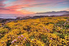
The Lost Coast is a mostly natural and undeveloped area of the California North Coast in Humboldt and Mendocino Counties, which includes the King Range. It was named the "Lost Coast" after the area experienced depopulation in the 1930s. In addition, the steepness and related geotechnical challenges of the coastal mountains made this stretch of coastline too costly for state highway or county road builders to establish routes through the area, leaving it the most undeveloped and remote portion of the California coast. Without any major highways, communities in the Lost Coast region such as Petrolia, Shelter Cove, and Whitethorn are somewhat isolated from the rest of California.

The Coast Ranges of California span 400 miles (644 km) from Del Norte or Humboldt County, California, south to Santa Barbara County. The other three coastal California mountain ranges are the Transverse Ranges, Peninsular Ranges and the Klamath Mountains.

The California Coastal National Monument is located along the entire coastline of the U.S. state of California. This monument ensures the protection of all islets, reefs and rock outcroppings along the coast of California within 12 nautical miles (22 km) of shore along the entire 840-mile (1,350 km) long coastline. Conservative estimates are for at least 20,000 such outcroppings. The monument was created by Bill Clinton via Presidential proclamation on January 11, 2000, with the authority in section two of the Antiquities Act of 1906. As of 2014, the monument has expanded to 2,272 acres (919 ha). The U.S. Bureau of Land Management, an agency of the U.S. Department of the Interior that manages the monument, has developed gateways in cooperation with other agencies along the California coast to introduce the monument to the public. These include the Trinidad, Point Arena, Fort Bragg-Mendocino, Pigeon Point Lighthouse, Piedras Blancas State Marine Reserve and Marine Conservation Area, and the Palos Verdes Peninsula. Although being the most-viewed national monument in California, people are usually unaware that the entire coastline is a national monument.

The Mendocino Range is one of several coastal mountain ranges which compose the Pacific Coast Range. This massive range of coastal mountains was formed during a period of coastal orogeny, millions of years ago. The Mendocino Range is a component of the California Coast Ranges of California. The Klamath Range is north of this region, and the Cascade Range runs to the northeast.

The Mattole River is a river on the north coast of California, that flows northerly, then westerly into the Pacific Ocean. The vast majority of its 62 miles (100 km) course is through southern Humboldt County, though a short section of the river flows through northern Mendocino County. Communities, from north to south, closely associated with the Mattole River include: Petrolia, Honeydew, Ettersburg, Thorn Junction, and Whitethorn. The river enters the ocean at the Mattole Estuary about 4 miles (6.4 km) west-southwest of Petrolia and 10 miles (16 km) south of Cape Mendocino.
Petrolia is an unincorporated community in Humboldt County, California, 10 miles (16 km) southeast of Cape Mendocino, at an elevation of 121 feet (37 m) above sea level, within ZIP Code 95558, and area code 707. Petrolia was the site of the first oil well drilled in California.

Shelter Cove is a census-designated place in Humboldt County, California. It lies at an elevation of 138 feet. Shelter Cove is on California's Lost Coast where the King Range meets the Pacific Ocean. A nine-hole golf course surrounds the one-runway Shelter Cove Airport at the center of Shelter Cove's commercial district. Utilities are provided by the Humboldt County Resort Improvement District #1 and boating access to the sea is managed by the Humboldt Bay Harbor, Recreation & Conservation District. The population was 803 at the 2020 census.

The Coast Range ecoregion is a Level III ecoregion designated by the Environmental Protection Agency (EPA) in the U.S. states of Washington, Oregon, and California. It stretches along the Pacific Coast from the tip of the Olympic Peninsula in the north to the San Francisco Bay in the south, including Grays Harbor, Willapa Bay, and the Long Beach Peninsula in Washington, the entire length of the Oregon Coast, and the Northern California Coast. Named for the Coast Range mountains, it encompasses the lower elevations of the Olympic Mountains, the Oregon Coast Range, the Californian North Coast Ranges, and surrounding lowlands.

The Yolla Bolly–Middle Eel Wilderness is a federally designated wilderness area in the Yolla Bolly Range of the southern Klamath Mountains and the Inner Northern California Coast Ranges, in Northern California.

Sinkyone Wilderness State Park is a state park in Mendocino County, California. The wilderness area borders the Pacific Ocean to the west and the King Range National Conservation Area to the north. The nearest settlement is the unincorporated town of Leggett. The lack of major road and highway access has led to the Sinkyone Wilderness area being referred to as the Lost Coast.

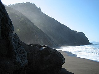
The King Range Wilderness is a 42,585-acre (172 km2) federally designated wilderness area within the King Range National Conservation Area in northern California, United States. The area was set aside with the passage of the Northern California Coastal Wild Heritage Wilderness Act of 2006. The Bureau of Land Management is the responsible agency. This section of California's coastline is known as the Lost Coast, a landscape too rugged for highway building, which forced the construction of State Highway 1 and U.S. 101 inland. The King Range Wilderness is the longest undeveloped coast, outside of Alaska, in the United States.

The Bald Hills War (1858–1864) was a war fought by the forces of the California Militia, California Volunteers and soldiers of the U.S. Army against the Chilula, Lassik, Hupa, Mattole, Nongatl, Sinkyone, Tsnungwe, Wailaki, Whilkut and Wiyot Native American peoples.

Berryessa Snow Mountain National Monument is a national monument of the United States comprising 344,476 acres (139,404 ha) of the California Coast Ranges in Napa, Yolo, Solano, Lake, Colusa, Glenn and Mendocino counties in northern California. Cache Creek Wilderness is located within the monument.
Sequoia County was a proposal in the early 1990s, to create a new county out of parts of Southern Humboldt and Northern Mendocino counties in California. The 1992 proposal halted signature gathering due to low support. The proponents of the proposal, restarted in 1993, submitted signatures in January 1994 to the Humboldt County clerk, who validated 2,033 signatures, 169 short of the necessary number to qualify for possible inclusion on the 1996 ballot.