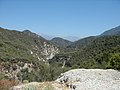
The San Gabriel Mountains, part of the Angeles National Forest. The southwest view from Islip Saddle shows Bear Creek, a tributary of the San Gabriel River that lies within the San Gabriel Wilderness, and Twin Peaks (7,761 feet (2,366m)).
Early Native American cultural sites in the inland mountain regions corresponding with the Angeles National Forest are sparse, Radiocarbon dates of 7675 and 7600 years Before Present (BP), taken from a cooking feature in one of the northern drainages of the San Gabriel Mountains, are the oldest known from the central Transverse Ranges. Early material culture indicates extensive use of grinding implements to process small seeds, supplemented by hunting activities. Numerous cogged stones are also found within sites of this period, indicating ceremonial activities.
During the Middle Period (5000 BP to 800 BP), sites generally indicate an increase in population and broadening of the resource base in response to population pressure and resource stress. This period is represented by a large array of specialized subsistence sites, characterized as villages, base camps, food processing and procurement sites, special use sites, rockshelters, pictographs, ovens, and cemeteries.
A Late Period (800 BP to AD 1769) proliferation of sites within the Angeles National Forest indicates a marked increase in regional population. Village provinces, composed of politically and economically-aligned villages may have existed during this period. Subsistence efforts in the mountains appear to focus on hunting, marked by the appearance of the bow and arrow. Greater regional interaction is marked by an increase in non-local materials, indicative of widespread interregional trade networks.
The first reported European contact for the area of the Angeles was in 1769 when the expedition of Gaspar de Portola traveled through the neighboring valleys on his way to Monterey. Early non-Native American use of the Forest centered on early explorers traveling through the area, while early land grants, missions, and townsites surrounded the Forest area. The construction of the missions of San Gabriel Archangel (1771) and San Fernando Rey de España (1797) cemented Spanish presence in the region. In the first two decades of the 19th Century, the Mission System drew in large numbers of Indian neophytes for baptism, completely changing the cultural landscape of the area. A number of subordinate Missions, or Estancias, were built with native labor as outposts to serve as mission-affiliated ranchos, overseeing localized operations. The Spanish Missions generally occupied the lands in the lowlands but relied heavily on the mountains for water, building supplies, and game. By 1800, local Native American traditional cultural lifestyles of had largely disappeared due to devastating European influences, including diseases and incorporation into the Mission System.
The first documented instance of timber activity in the local mountains was in 1819 when Joseph Chapman cut down timber in Millard Canyon (also called Church Canyon) for use in the construction of the Plaza Church in El Pueblo de Nuestra Señora la Reina de los Angeles de Porciuncula (now just ‘Los Angeles’). It has also been said that timbers for the San Fernando Mission came from the Tujunga Canyons, and for the San Gabriel Mission came from Little Icehouse Canyon and Little Santa Anita Canyon.
With the Independence of Mexico in 1821, the area of the Forest came under Mexican control. The Mexican Period is typified by the secularization of the Mission system, and the appearance of large land grants, called Ranchos. The major activities involved livestock and farming, and peripheral areas were regularly involved in these activities, as vaqueros sought out timber, water, prey, sport, and stray cattle and horses. Use of the highlands may have included seasonal livestock grazing, utilizing some of the springs in the area.
It was during this period that gold was discovered in Placerita Canyon, in 1842, the first authenticated discovery of gold in California. It started California's "first" gold rush. Soon after the later discovery of gold at Sutter’s Mill in 1848, and subsequent conflict between the United States and Mexico, California became part of the United States. Almost immediately large numbers of American migrants began crossing the desert. Merchants and landowners settled in communities throughout the southern California region. Miners poured into the mountains primarily following original and modified Indian trails. Large placer and lode mining operations were established in the San Gabriels, with mixed success. Although the mountains were honeycombed with quartz veins, and a host of small mines were gouged out of the slopes in an attempt to strike gold, many of the ventures were inactive by 1896. The last flurries of serious mining in the region largely ended by the late 1930s. Building of major roads began in the 1850s and railroads passed through Soledad Canyon and Cajon Pass a short time later. Don Benito Wilson, in 1864, built a road into the Forest to harvest wood for fence posts, wine barrels, pickets and shingles. With the majority of Forest composed of chaparral, timber has not played a large role on the Forest, with commercial timber activities virtually ceasing in the Forest during the mid-1950s.
The Great Hiking Era of the San Gabriel Mountains (AD 1880 – 1938) saw increasing use of the rugged backcountry for recreational purposes by the foothill communities, coinciding with the real estate boom in the lowlands and the great interest in hiking, hunting and fishing by the urban populations. In particular, six major hiking trails converged at Red Box Saddle. Settlements started inside the Forest boundaries in the forms of homesteads and resorts in the southern section, and, in the less steep northern section, ranches and homesteads. In 1891, the first homestead was filed in the Big Tujunga Canyon area, and others soon followed. Homestead patents were established throughout the range, with the last being granted on the Angeles National Forest in 1938. A number of resorts and camps sprang up, and these supported the increasing numbers of hikers and campers who forged into the wilderness. In 1889, the first telescope made its arduous journey up to the summit of Mt. Wilson. A small observatory of canvas and wood, run by Harvard and USC astronomers, was later replaced in 1904 by the more famous institution run by George Ellery Hale. Mount Wilson Observatory would quickly rise to dominate astronomy worldwide. It was home to the world's two largest telescopes as well as the most powerful facilities in existence for studying the sun.
In 1891, preliminary work began on an electric cable incline railway from Rubio Canyon to Echo Mountain, a feat never before attempted in the world. Professor Thaddeus S. C. Lowe, an energetic entrepreneur who had garnered fame in the Civil War by ballooning for the Union Army, undertook the venture. In its height at the turn of the century, the Mount Lowe Railway was the most popular tourist attraction in California, comparable to a modern-day Disneyland. In its 43 year history, it saw over three million recorded visitors. In 1938, the most destructive rainstorm in recent memory washed away so much of the track that the railway was abandoned. Much of the ruins of the Mt Lowe Railway are still accessible above Pasadena for interpretive hikes.
On December 20, 1892, the San Gabriel Timberland Reserve was created by President Harrison. The creation of the Reserve, which was the forerunner of the Angeles, was in response to public concern about watershed values as early as 1883. Floods resulting from fire denuded slopes were causing problems with the lowland populations. In 1905, the Reserves were transferred from the Department of the Interior to the Department of Agriculture, and renamed National Forest in 1907. The San Gabriel National Forest consisted of the southern section of the present day Angeles and portions of the San Bernardino Forest. In 1908, the name was changed to Angeles National Forest. In 1926, the eastern area was divided and San Bernardino National Forest recreated. At this time, the Saugus (now part of the Santa Clara-Mojave Rivers Ranger District) was detached from the Santa Barbara Reserve and joined with the Angeles.[6]
The San Gabriel Forest Reserve was established on December 20, 1892, the San Bernardino Forest Reserve was established on February 25, 1893, and the Santa Barbara Forest Reserve was established on December 22, 1903. Together, they became National Forests on March 4, 1907, and they were combined on July 1, 1908, with all of the San Bernardino forest and portions of San Gabriel forest and Santa Barbara forest composing the new Angeles National Forest. In 1916, there was a movement to create the Sierra Madre National Park, but that never occurred.[7]
The campgrounds at Broken Blade, Twisted Arrow and Pima Loops were closed on July 26, 2013, after squirrel infected with bubonic plague was discovered.[9]
On November 1, 1966, a fire started at 5:19a.m. on the Los Pinetos Nike Site (LA-94). The fire spread, threatening medical facilities and residential areas south edge of the national forest. 12 firefighters with United States Forest Service's El Cariso "Hot Shot" crew were killed when they were caught in a flare up in a canyon. 11 more firefighters were seriously burned in the incident.[10] The fire was brought under control at 1:00p.m. on November 2, having burned 2,028 acres (8.21km2).[10]
In the Station Fire, more than 161,000 acres (650km2) of the forest were burned by an arson fire that began on August 26, 2009, near Angeles Crest Highway in La Cañada and quickly spread, fueled by dry brush that had not burned for over 150 years. The fire burned for more than a month and was the worst in Los Angeles County history, charring 250 square miles (650km2), approximately one-fourth of the forest; displacing wildlife, and destroying 91 homes, cabins and outbuildings and the family-owned Hidden Springs Cafe.
During the fire, two firefighters died after driving off the Mt. Gleason County Road looking for an alternate route to get the inmates out at Camp 16. The Station Fire threatened the Mount Wilson Observatory atop Mt. Wilson . The site includes two telescopes, two solar towers, and transmitters for 22 television stations, several FM radio stations, and police and fire department emergency channels. Although the fire scorched one side of the outhouse at amateur-owned Stony Ridge Observatory, six miles northeast of Mt. Wilson, aside from minor damage from smoke and ash infiltration, the remainder of the observatory and its historic 30-inch Carroll telescope survived.
In September and October 2020, the Bobcat Fire burned 115,796 acres (180.931sqmi) (468km2) in the central San Gabriel Mountains of the Angeles National Forest. It was one of the largest wildfires in Los Angeles County history.[11]
On September 8, 2024, the Bridge Fire broke out near East Fork and Glendora Mountain roads in the Angeles National Forest. It quickly burned through much of the eastern portion of the forest and the Sheep Mountain Wilderness. On September 10, it crossed into San Bernardino County after seeing rapid growth. Evacuation orders were prompted for Mount Baldy Village and Wrightwood as the fire approached the communities.[12] By the time it was contained, the fire burned a total of 56,030 acres (22,675ha; 88sqmi; 227km2) and destroyed 81 structures.[13] The fire caused the Angeles National Forest to order closures for a large area of the forest in and around the burned area until December 31, 2024.[14]
Various mountain plant life with the Chaparral yucca at right.
Much of this National Forest is covered with dense chaparral shrub forests with oak woodlands, which changes to pine and fir-covered slopes in the higher elevations. Subsequent to the fire there was a heavy growth of poodle-dog bush, apparently triggered by the fire's effect on dormant seeds, that lasted for several years. The plant produces prolific lavender flowers. Unfortunately, as visitors to the Forest discovered, contact with it may cause a poison-oak-like rash.
A National Forest Adventure Pass is required for parking at many locations in the Angeles National Forest and other National Forests in Southern California, and this can be obtained online or from visitor centers and local merchants.[17]Los Angeles County has declared that passes are not required on county-maintained roads. There are also many other areas that do not require the pass.
General information
Angeles National Forest, the two green areas north of Los Angeles.
All the above mountains are part of the San Gabriel Mountains, except for Burnt Peak, Liebre Mountain, Sawmill Mountain, Sawtooth Mountain, Grass Mountain, Redrock Mountain and Warm Springs Mountain, which are all in the Sierra Pelona Mountains.
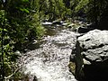
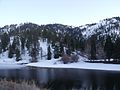
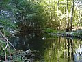
Water recreation
Pyramid Lake is located next to Interstate 5 (take Smokey Bear exit), 20 miles (32km) north of Magic Mountain Amusement Park in Valencia, California.
Castaic Lake is located 7 miles (11km) north of Magic Mountain Amusement Park in Valencia, California, just off Interstate 5 (take Lake Hughes exit.) The lake is managed by the L.A. County Department of Parks and Recreation
Elizabeth Lake is located approximately 10 miles (16km) west of Palmdale, California, on Elizabeth Lake Rd. It can completely dry up in drought years.
Jackson Lake is another natural lake located on the San Andreas Fault about 3 miles (4.8km) west of the Big Pines Visitor Center and roughly 7 miles (11km) west of the community of Wrightwood, California.
Lowelifes Trail Crew: Lowelifes focuses on trail work in Southern California's Angeles National Forest, fostering conservation, sustainability, & community in Los Angeles County.[27]
The Volunteers of the Angeles National Forest (VANF) are the representatives of USFS at Big Pines Visitor Center, located 3 miles west of the town of Wrightwood. The Visitor Center supplies information, directions and education to the public by staffing the center on weekends, providing handouts, and displaying preserved local forest animals, birds, and reptiles.[28]
The California Historical Landmark Marker NO. 717 at San Gabriel Mountain, Clear Creek vista point, State Hwy 2, 8.3mi N of I-210, La Canada reads:[29]
NO. 717 THE ANGELES NATIONAL FOREST - The first national forest in the State of California and second in the United States, Angeles National Forest was created by proclamation of President Benjamin Harrison on December 20, 1892. The first name given to the forest, "'San Gabriel Timberland Reserve," was changed to "San Gabriel National Forest" March 4, 1907, and then to "Angeles National Forest" on July 1, 1908..
Leadabrand, Russ (1963). Guidebook to the San Gabriel Mountains of California. Los Angeles: Ritche Press. ISBN0378034227.{{cite book}}: ISBN / Date incompatibility (help)
Robinson, John W. (1977). The San Gabriels: Southern California Mountain Country. San Marino: Goldwest Books. ISBN9780870950612.
This page is based on this Wikipedia article Text is available under the CC BY-SA 4.0 license; additional terms may apply. Images, videos and audio are available under their respective licenses.


