Santa Cruz is the largest city and the county seat of Santa Cruz County, in Northern California. As of the 2020 census, the city population was 62,956. Situated on the northern edge of Monterey Bay, Santa Cruz is a popular tourist destination, owing to its beaches, surf culture, and historic landmarks.

Robert Kelly Slater is an American professional surfer, best known for being crowned World Surf League champion a record 11 times. Slater is widely regarded as the greatest professional surfer of all time, and holds 56 Championship Tour victories. Slater is also the oldest surfer still active on the World Surf League, winning his 8th Billabong Pipeline Masters title at age 49.
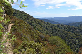
Castle Rock State Park is a 5,242-acre (2,121 ha) state park of California, United States, located along the crest of the Santa Cruz Mountains and almost entirely in Santa Cruz County, with parts extending into Santa Clara County and San Mateo County. It embraces coast redwood, Douglas fir, and madrone forest, most of which has been left in its wild, natural state. Steep canyons are sprinkled with unusual rock formations that are a popular rock climbing area. The park is named after a sandstone formation called Castle Rock. The forest here is lush and mossy, crisscrossed by 32 miles (51 km) of hiking trails. These trails are part of an even more extensive trail system that links the Santa Clara and San Lorenzo valleys with Castle Rock State Park, Big Basin Redwoods State Park, and the Pacific Coast. Due to its overnight parking lot, Castle Rock is a popular starting point for the Skyline-to-the-Sea Trail, a 30-mile (48 km) trail that begins near by at Saratoga Gap and leads to Waddell Beach north of Santa Cruz. There are two walk-in campgrounds within the park for overnight backpacking.

San Onofre State Beach is a 3,000-acre (1,214 ha) state park in San Diego County, California. The beach is 3 miles (5 km) south of San Clemente on Interstate 5 at Basilone Road. The state park is leased to the state of California by the United States Marine Corps. Governor Ronald Reagan established San Onofre State Beach in 1971. With over 2.5 million visitors per year, it is one of the five most-visited state parks in California, hosting swimmers, campers, kayakers, birders, fishermen, bicyclists, sunbathers, surfers, and the sacred Native American site of Panhe.

Leo Carrillo State Park is a state park in Los Angeles County, California, United States. Situated along the Malibu coast, the park is a component of Santa Monica Mountains National Recreation Area. With 1.5 miles (2.4 km) of beach, the parkland stretches into the Santa Monica Mountains. The park has expanded into Ventura County and also includes management of County Line Beach. California State Route 1 runs through the park, where it intersects with the western terminus of the Mulholland Highway. The 2,513-acre (1,017 ha) park was established in 1953. It is named for actor and conservationist Leo Carrillo (1880–1961), who served on the State Parks commission.

Natural Bridges State Beach is a 65-acre (26 ha) California state park in Santa Cruz, California, in the United States. The park features a natural bridge across a section of the beach. It is also well known as a hotspot to see monarch butterfly migrations. The Monarch Butterfly Natural Preserve is home to up to 150,000 monarch butterflies from October through early February.

Doheny State Beach is a protected beach in the state park system of California, United States, located on the Pacific Ocean in the city of Dana Point. The beach is a popular surf spot located at the mouth of San Juan Creek, which flows from the Santa Ana Mountains southwest to the beach, where it forms a fresh-water lagoon.

Huntington State Beach is a protected beach in Southern California, located in the City of Huntington Beach in Orange County. It extends 2 miles (3.2 km) from Newport Beach north to Beach Boulevard, where the Huntington City Beach begins. The 121-acre (49 ha) park was established in 1942.

Corona del Mar State Beach is a protected beach in the state park system of California, United States. It is located in Corona del Mar, Newport Beach, and operated by the city of Newport Beach. The 30-acre (12 ha) park was established in 1947.

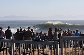
Surf culture includes the people, language, fashion, and lifestyle surrounding the sport of surfing. The history of surfing began with the ancient Polynesians. That initial culture directly influenced modern surfing, which began to flourish and evolve in the early 20th century, with its popularity peaking during the 1950s and 1960s. It has affected music, fashion, literature, film, art, and youth jargon in popular culture. The number of surfers throughout the world continues to increase as the culture spreads.
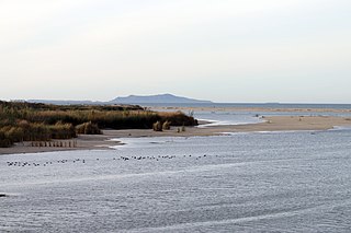
McGrath State Beach is a protected beach park located on the south bank of the mouth of Santa Clara River in the city of Oxnard, California. McGrath State Beach is one of the best bird-watching areas in California, with the lush riverbanks of the Santa Clara River and sand dunes along the shore. A nature trail leads to the Santa Clara Estuary Natural Preserve. Camping sites are available. Two miles of beach provide surfing and fishing opportunities. Just south of the station is the undeveloped Mandalay Beach Park which is about a mile downcoast beach walk from the park or a bike ride along Harbor Blvd. Located south of Ventura on Harbor Boulevard, the beach is on the Pacific Coast Bicycle Route and the California Coastal Trail.
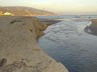
Malibu Lagoon State Beach in Malibu, California, United States, is also known as Surfrider Beach. It was dedicated as the first World Surfing Reserve on October 9, 2010. The 110-acre (45 ha) site was established as a California state park in 1951. It lies within the Santa Monica Mountains National Recreation Area.

The California Coastal National Monument is located along the entire coastline of the U.S. state of California. This monument ensures the protection of all islets, reefs and rock outcroppings along the coast of California within 12 nautical miles (22 km) of shore along the entire 840-mile (1,350 km) long coastline. Conservative estimates are for at least 20,000 such outcroppings. The monument was created by Bill Clinton via Presidential proclamation on January 11, 2000, with the authority in section two of the Antiquities Act of 1906. As of 2014, the monument has expanded to 2,272 acres (919 ha). The U.S. Bureau of Land Management, an agency of the U.S. Department of the Interior that manages the monument, has developed gateways in cooperation with other agencies along the California coast to introduce the monument to the public. These include the Trinidad, Point Arena, Fort Bragg-Mendocino, Pigeon Point Lighthouse, Piedras Blancas State Marine Reserve and Marine Conservation Area, and the Palos Verdes Peninsula. Although being the most-viewed national monument in California, people are usually unaware that the entire coastline is a national monument.
The Santa Cruz Surfing Museum is a museum which was established in May 1986 to document the history of surfing. With collections dating back to the earliest years of surfing on mainland United States, the museum houses a historical account of surfing in Santa Cruz, California.
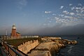
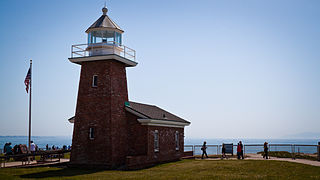
Steamer Lane is a famous surfing location in Santa Cruz, California. It is just off a point on the side of cliffs in the West Cliff residential area near downtown Santa Cruz, providing easy access and a good vantage point for viewing. The Santa Cruz Surfing Museum is housed in a lighthouse there. "Steamer Lane" is the preferred form of the name used by the people surfing there. Steamer Lane was named by Claude Horan while he was a student at San Jose State in the late 1930s. One flat calm day he and his friend Wes Hammond thought it would be a good idea to hire steamships to cruise back and forth to generate waves for surfing. It was at Steamer Lane that the modern surfing wetsuit and the leash were mainly developed by Jack O'Neill, who had his surf shop nearby for many years.
The title "Surf City, USA" was the subject of a trademark dispute between the California coastal cities of Huntington Beach and Santa Cruz. Both cities historically claimed the "Surf City" moniker, but the dispute intensified in 2004 after the Huntington Beach Conference and Visitors Bureau successfully filed the "Surf City USA" trademark with the U.S. Patent and Trademark Office. A settlement was eventually reached in January 2008, which allows Huntington Beach to retain the trademark.

Pleasure Point is a census-designated place (CDP) in Santa Cruz County, California. Pleasure Point sits at an elevation of 33 feet (10 m). The 2020 United States census reported Pleasure Point's population was 5,821. Prior to the 2010 census, this CDP was called Opal Cliffs.
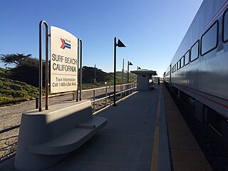
Surf is an unincorporated area of Santa Barbara County, California, located along the Pacific coast within a publicly accessible area of Vandenberg Space Force Base west of the city of Lompoc. The site originally was established as a railroad town, with its growth peaking after Vandenberg was established in 1941. Since 2000 the site has just consisted of Surf Beach and the unstaffed Lompoc–Surf Amtrak Station. California State Route 246 used to run to Surf, but in 1984 the highway was truncated at Lompoc and the road from Lompoc to Surf is designated West Ocean Avenue.

Surfing in the United States is a popular hobby in coastal areas, and more recently due to the invention of wave pools, inland regions of the country. It contributes to a lifestyle and culture in which millions participate and which millions more have an interest. USA surfing is the governing body for the sport of surfing in the United States, with surf leagues such as the World Surf League available in the country. Surfing can be traced back to 17th Century Hawaii and has evolved over time into the professional sport it is today, with surfing being included for the first time in the 2020 Summer Olympics in Tokyo.

"Surfin' U.S.A." is a song by the American rock band the Beach Boys, credited to Chuck Berry and Brian Wilson. It is a rewritten version of Berry's "Sweet Little Sixteen" set to new lyrics written by Wilson and an uncredited Mike Love. The song was released as a single on March 4, 1963, backed with "Shut Down". It was then placed as the opening track on their album of the same name.