
Santa Cruz is the largest city and the county seat of Santa Cruz County, in Northern California. As of the 2020 census, the city population was 62,956. Situated on the northern edge of Monterey Bay, Santa Cruz is a popular tourist destination, owing to its beaches, surf culture, and historic landmarks.
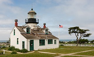
Pacific Grove is a coastal city in Monterey County, California, in the United States. The population at the 2020 census was 15,090. Pacific Grove is located between Point Pinos and Monterey.
The Santa Cruz Beach Boardwalk is an oceanfront amusement park in Santa Cruz, California. Founded in 1907, it is California's oldest surviving amusement park and one of the few seaside parks on the West Coast of the United States.

Davenport is a census-designated place (CDP) in Santa Cruz County, California. Davenport sits at an elevation of 259 feet (79 m). The 2020 United States census reported Davenport's population was 388.

Monterey Bay National Marine Sanctuary (MBNMS) is a federally protected marine area offshore of California's Big Sur and central coast in the United States. It is one of the largest US national marine sanctuaries and has a shoreline length of 276 miles (444 km) stretching from just north of the Golden Gate Bridge at San Francisco to Cambria in San Luis Obispo County. Supporting one of the world's most diverse marine ecosystems, it is home to numerous mammals, seabirds, fishes, invertebrates and algae in a remarkably productive coastal environment. MBNMS was designated on September 18, 1992, for the purpose of resource protection, research, education, and compatible public use.

Natural Bridges State Beach is a 65-acre (26 ha) California state park in Santa Cruz, California, in the United States. The park features a natural bridge across a section of the beach and a eucalyptus grove provides habitat for monarch butterflies. During monarch butterfly migration, Monarch Butterfly Natural Preserve has up to 150,000 monarch butterflies from October through early February.

Lighthouse Field State Beach is a protected beach in the state park system of California, United States. It is located in the city of Santa Cruz at the north end of Monterey Bay. The beach overlooks the Steamer Lane surfing hotspot. It also contains the Santa Cruz Surfing Museum, housed in a 1967 lighthouse. The 38-acre (15 ha) site was established in 1978.
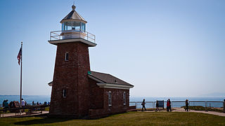
The Santa Cruz Surfing Museum is a museum which was established in May 1986 to document the history of surfing. With collections dating back to the earliest years of surfing on mainland United States, the museum houses a historical account of surfing in Santa Cruz, California.

The Pleasure Point Roadhouse was a historic building on the Monterey Bay, located at 2-3905 East Cliff Dr., 95062 in Santa Cruz County, California. It was torn down on September 27, 2008.

Jack O'Neill was an American businessman and founder of the surfwear and surfboard company O'Neill.

Asilomar State Marine Reserve (SMR) is one of four small marine protected areas (MPAs) located near the cities of Monterey and Pacific Grove, at the southern end of Monterey Bay on California’s central coast. The four MPAs together encompass 2.96 square miles (7.7 km2). The SMR protects all marine life within its boundaries. Fishing and take of all living marine resources is prohibited.

Lovers Point State Marine Reserve (SMR) is one of four small marine protected areas located near the cities of Monterey and Pacific Grove, at the southern end of Monterey Bay on California’s central coast. The four MPAs together encompass 2.96 square miles (7.7 km2). The SMR protects all marine life within its boundaries. Fishing and take of all living marine resources is prohibited.

Pacific Grove Marine Gardens State Marine Conservation Area is one of four small marine protected areas located near the cities of Monterey and Pacific Grove, at the southern end of Monterey Bay on California’s central coast. The four MPAs together encompass 2.96 square miles (7.7 km2). Within the SMCA fishing and take of all living marine resources is prohibited except the recreational take of finfish and the commercial take of giant and bull kelp by hand under certain conditions. According to the Frommer's guide, the Marine Gardens area is "renowned for ocean views, flowers, and tide-pool seaweed beds."
Portuguese Ledge State Marine Conservation Area (SMCA) is an offshore marine protected area in Monterey Bay. Monterey Bay is on California's central coast with the city of Monterey at its south end and the city of Santa Cruz at its north end. The SMCA covers 10.9 square miles (28 km2). Within the SMCA fishing and take of all living marine resources is prohibited except the commercial and recreational take of pelagic finfish.

Soquel Canyon State Marine Conservation Area (SMCA) is an offshore marine protected area in Monterey Bay. Monterey Bay is on California’s central coast with the city of Monterey at its south end and the city of Santa Cruz at its north end. The SMCA covers 23.41 square miles (60.6 km2). Within the SMCA, fishing and taking of any living marine resources is prohibited except the commercial and recreational take of pelagic finfish.
Carrier Pigeon was an American clipper ship that was launched in the fall of 1852 from Bath, Maine. Her value was estimated at US$54,000. She was wrecked on her maiden voyage off the north coast of what was then Santa Cruz County in the state of California.

The Santa Cruz Small Craft Harbor is situated in Santa Cruz, California, on the site of the former Woods Lagoon. Built in 1962–1963, its public use specializes in boating and extracurricular marine activities for the local community and visitors. The harbor straddles the city limits which runs down the center of Arana Gulch; the west side of the harbor is in Santa Cruz's Seabright neighborhood while the east is in unincorporated Santa Cruz County.

Moss Landing Wildlife Area is a California State wildlife preserve on the shore of Elkhorn Slough.

Pleasure Point is a census-designated place (CDP) in Santa Cruz County, California. Pleasure Point sits at an elevation of 33 feet (10 m). The 2020 United States census reported Pleasure Point's population was 5,821. Prior to the 2010 census, this CDP was called Opal Cliffs.


