
Mission Santa Clara de Asís is a Spanish mission in the city of Santa Clara, California. The mission, which was the eighth in California, was founded on January 12, 1777, by the Franciscans. Named for Saint Clare of Assisi, who founded the order of the Poor Clares and was an early companion of St. Francis of Assisi, this was the first California mission to be named in honor of a woman.
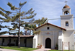
Mission Santa Cruz is a replica Spanish Californian mission in Santa Cruz, California. Located at the foot of a what would later be named Mission Hill, the original mission was founded on August 28, 1791, by Father Fermín Francisco de Lasuén, the successor of Father Junipero Serra. The mission was dedicated that same year, and in the winter, the waters of the San Lorenzo River flooded its banks, and caused extensive damage to the original building, and so the mission was relocated to the top of Mission Hill. After earthquake damage and years of neglect, this second mission fell into disrepair, and much of it, though not all, was removed to accommodate the construction of the Holy Cross Church. The Holy Cross Church paid for the construction of the replica in the 1930s, and today it functions as a historical monument and chapel for the parish.

Santa Cruz is the largest city and the county seat of Santa Cruz County, in Northern California. As of the 2020 census, the city population was 62,956. Situated on the northern edge of Monterey Bay, Santa Cruz is a popular tourist destination, owing to its beaches, surf culture, and historic landmarks.

Santa Cruz County, officially the County of Santa Cruz, is a county on the Pacific coast of the U.S. state of California. As of the 2020 census, the population was 270,861. The county seat is Santa Cruz. Santa Cruz County comprises the Santa Cruz–Watsonville, CA Metropolitan Statistical Area, which is also included in the San Jose–San Francisco–Oakland, CA Combined Statistical Area. The county is on the California Central Coast, south of the San Francisco Bay Area region. The county forms the northern coast of the Monterey Bay, with Monterey County forming the southern coast.

The Santa Cruz Mountains are a mountain range in central and Northern California, United States, constituting a part of the Pacific Coast Ranges. They form a ridge down the San Francisco Peninsula, south of San Francisco. They separate the Pacific Ocean from the San Francisco Bay and the Santa Clara Valley, and continue south to the Central Coast, bordering Monterey Bay and ending at the Salinas Valley. The range passes through the counties of San Mateo, Santa Clara, and Santa Cruz, with the Pajaro River forming the southern boundary.
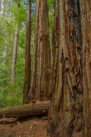
Big Basin Redwoods State Park is a state park in the U.S. state of California, located in Santa Cruz County, about 36 km (22 mi) northwest of Santa Cruz. The park contains almost all of the Waddell Creek watershed, which was formed by the seismic uplift of its rim, and the erosion of its center by the many streams in its bowl-shaped depression.

Branciforte, originally named Villa de Branciforte, was the last of only three secular pueblos founded by the Spanish colonial government of Alta California. The pueblo was established in 1797 on the eastern bluff of the San Lorenzo River, facing Mission Santa Cruz on the west side of the river, in modern-day Santa Cruz, California. The pueblo never prospered, and the area was annexed into the city of Santa Cruz, California in 1905.
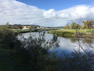
The San Lorenzo River is a 29.3-mile-long (47.2 km) river in the U.S. state of California. The name San Lorenzo derives from the Spanish language for "Saint Lawrence" due to its reported sighting on that saint's feast day by Spanish explorers. Its headwaters originate in Castle Rock State Park in the Santa Cruz Mountains and flow south by southeast through the San Lorenzo Valley before passing through Santa Cruz and emptying into Monterey Bay and the Pacific Ocean.

Thomas Fallon (1825–1885) an Irish-born Californian politician, best known for serving as 10th Mayor of San Jose. Fallon remains a controversial figure in San Jose's history, owing to his role in the American Conquest of California.
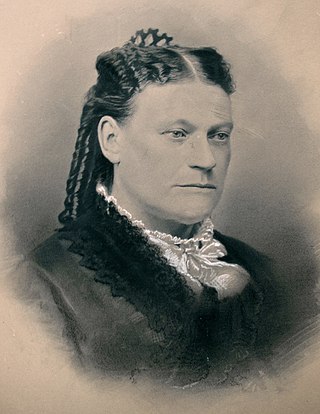
Juana Briones de Miranda was a Californio ranchera, medical practitioner, and merchant, often remembered as the "Founding Mother of San Francisco", for her noted involvement in the early development of the city of San Francisco. Later in her life, she also played an important role in developing modern Palo Alto.

The Rancho San Andrés Castro Adobe is a historically and architecturally significant house located in the Pájaro Valley, California. The two-story Rancho San Andrés Castro Adobe is a historic rancho hacienda that was built between 1848 and 1849.

The Larkin House is a historic house at 464 Calle Principal in Monterey, California. Built in 1835 by Thomas O. Larkin, it is claimed to be the first two-story house in all of California, with a design combining Spanish Colonial building methods with New England architectural features to create the popular Monterey Colonial style of architecture. The Larkin House is both a National and a California Historical Landmark, and is a featured property of Monterey State Historic Park.

Juan Bautista Rogers Cooper was a 19th-century pioneer of California, who held British, Mexican, and finally American citizenship. Raised in Massachusetts in a maritime family, he came to the Mexican territory of Alta California as master of the ship Rover, and was a pioneer of Monterey, California, when it was the capital of the territory. He converted to Catholicism, became a Mexican citizen, married the daughter of the Mexican territorial governor, and acquired extensive land holdings in the area prior to the Mexican–American War.

Adobe Creek, historically San Antonio Creek, is a 14.2-mile-long (22.9 km) northward-flowing stream originating on Black Mountain in the Santa Cruz Mountains. It courses through the cities of Los Altos Hills, Los Altos, and Palo Alto on its way to the Palo Alto Flood Basin and thence to southwestern San Francisco Bay in Santa Clara County, California, United States. Historically, Adobe Creek was a perennial stream and hosted runs of steelhead trout entering from the Bay, but these salmonids are now blocked by numerous flood control structures, including a tidal gate at the creek's mouth and a long concretized rectangular channel culminating in an impassable drop structure at El Camino Real. The co-founders of Adobe Systems both lived on Adobe Creek.

The Jose Eusebio Boronda Adobe is a Monterey Colonial style building from 1846, located in Salinas, Monterey County, California. The adobe was listed on the National Register of Historic Places on March 20, 1973, and is California Historical Landmark #870.
The Lost Adobe is a location at Mission Santa Cruz in Santa Cruz, California. The stone foundations of an unidentified adobe on the east edge of Mission Hill in Santa Cruz was first discovered in 1978. Prior to any excavations an extensive archival research program was carried out. After no mention was found in the written record, the foundations were given the name the Lost Adobe. Archaeological excavations indicated the presence of 18+ rooms' structural foundations extending west toward the original church and cemetery. Artifacts found were a diverse collection of Spanish Mission Era/ Mexican Republic materials including glass beads, Majolica ceramic fragments and phoenix buttons. These findings suggest that the structure was used to house the neophyte community of Yokuts and Ohlone families living at the Santa Cruz Mission in the 1820s and 1830s. The "Lost Adobe" collapsed during the 19th century, and no remnants remain. The area is on private property and visitors are not allowed.

The Glen Canyon Covered Bridge, near Santa Cruz, California, was a covered bridge built in 1892. It was listed on the National Register of Historic Places in 1984. It has since been demolished.
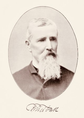
Thomas Theodore Tidball was an American pioneer who came out west during the time of the California gold rush. He was a veteran of the American Civil War who served as a captain in the Union Army. In 1866, Tidball settled in Jolon, California where he and George Dutton purchased the Antonio Ramirez adobe Inn in 1876 and converted it into a two-story hotel and stagecoach station. Tidball went on to establish his own General Store in 1890, which is now the only standing commercial building of Jolon. The Tidball Store is a landmark, which was listed on the National Register of Historic Places on December 12, 1976.

Tidball Store or Jolon General Store is located off Jolon Road in Jolon, California, United States, 1/4 mile south of the Dutton Hotel, Stagecoach Station. The store was constructed by pioneer, Thomas Theodore Tidball, from the remains of an old adobe inn, built in 1868 by Flint & Bixby Stage Lines. Tidball supplied food, clothing, building supplies and other necessities to customers traveling through and to local ranchers and miners. The store was a major stagecoach stop on the old El Camino Real in the late 1880s. The landmark was listed on the National Register of Historic Places on December 12, 1976. It is the only standing commercial building of Jolon, once a major community of southern Monterey County.


