State Route 1 (SR 1) is a major north–south state highway that runs along most of the Pacific coastline of the U.S. state of California. At a total of just over 659 miles (1,061 km), it is the longest state route in California. SR 1 has several portions designated as either Pacific Coast Highway (PCH), Cabrillo Highway, Shoreline Highway, or Coast Highway. Its southern terminus is at Interstate 5 (I-5) near Dana Point in Orange County and its northern terminus is at U.S. Route 101 (US 101) near Leggett in Mendocino County. SR 1 also at times runs concurrently with US 101, most notably through a 54-mile (87 km) stretch in Ventura and Santa Barbara counties, and across the Golden Gate Bridge.

San Mateo County, officially the County of San Mateo, is a county located in the U.S. state of California. As of the 2010 census, the population was 718,451. The county seat is Redwood City.
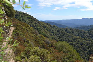
Castle Rock State Park is a 5,242-acre (2,121 ha) state park of California, USA, located along the crest of the Santa Cruz Mountains and almost entirely in Santa Cruz County, with parts extending into Santa Clara County and San Mateo County. It embraces coast redwood, Douglas fir, and madrone forest, most of which has been left in its wild, natural state. Steep canyons are sprinkled with unusual rock formations that are a popular rock climbing area. The forest here is lush and mossy, crisscrossed by 32 miles (51 km) of hiking trails. These trails are part of an even more extensive trail system that links the Santa Clara and San Lorenzo valleys with Castle Rock State Park, Big Basin Redwoods State Park, and the Pacific Coast. Due to its overnight parking lot, Castle Rock is a popular starting point for the Skyline-to-the-Sea Trail, a 30-mile (48 km) trail that begins near by at Saratoga Gap and leads to Waddell Beach north of Santa Cruz. There are two walk-in campgrounds within the park for overnight backpacking.

Brannan Island State Recreation Area is a state park unit of California, United States, preserving a maze of waterways in the Sacramento–San Joaquin River Delta. The recreation area is located in Sacramento County between Rio Vista and Isleton. This park northeast of San Francisco Bay has countless islands and marshes with many wildlife habitats and many opportunities for recreation, including boating, windsurfing and swimming. The 329-acre (133 ha) park was established in 1952.

Baker Beach is a public beach on the peninsula of San Francisco, California, U.S.. The beach lies on the shore of the Pacific Ocean in the northwest of the city. It is roughly a half mile long, beginning just south of Golden Gate Point, extending southward toward the Seacliff peninsula, the Palace of the Legion of Honor and the Sutro Baths. The northern section of Baker Beach is "frequented by clothing-optional sunbathers," and as such it is considered a nude beach.

Capistrano Beach, also known as Capo Beach, is a populated place in the city of Dana Point in Orange County, California. It is bordered by San Clemente to the south and Doheny State Beach to the north.

The Monterey Bay National Marine Sanctuary (MBNMS) is a US Federally protected marine area offshore of California's central coast. It is the largest US national marine sanctuary and has a shoreline length of 276 miles (444 km) stretching from just north of the Golden Gate Bridge at San Francisco to Cambria in San Luis Obispo County. Supporting one of the world’s most diverse marine ecosystems, it is home to numerous mammals, seabirds, fishes, invertebrates and plants in a remarkably productive coastal environment. The MBNMS was established in 1992 for the purpose of resource protection, research, education, and public use.

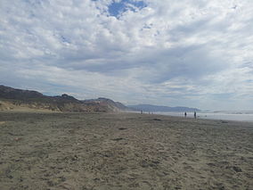
San Gregorio State Beach is a beach near San Gregorio, California, USA, south of Half Moon Bay. Part of the California State Park System, the beach lies just west of the intersection of California State Route 1 and State Route 84.

Half Moon Bay State Beach is a 4-mile (6 km) stretch of protected beaches in the state park system of California, USA, on Half Moon Bay. From north to south it comprises Roosevelt, Dunes, Venice, and Francis Beaches. The 181-acre (73 ha) park was established in 1956.
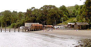
China Camp State Park is a state park of California, United States, surrounding a historic Chinese American shrimp-fishing village and a salt marsh. The park is located in San Rafael, California, on the shore of San Pablo Bay. It is known for its hiking and mountain biking trails, scenic views, and open spaces. The 1,514-acre (613 ha) park was established in 1976. A 75-acre (30 ha) district, including the shrimping village and a prehistoric shell midden, were added to the National Register of Historic Places in 1979 for having state-level significance in archaeology, architecture, commerce, settlement, and social history.

McGrath State Beach is a protected beach park located on the south bank of the mouth of Santa Clara River in the city of Oxnard, California. McGrath State Beach is one of the best bird-watching areas in California, with the lush riverbanks of the Santa Clara River and sand dunes along the shore. A nature trail leads to the Santa Clara Estuary Natural Preserve. Camping sites are available. Two miles of beach provide surfing and fishing opportunities. Just south of the station is the undeveloped Mandalay Beach Park which is about a mile downcoast beach walk from the park or a bike ride along Harbor Blvd. Located south of Ventura on Harbor Boulevard, the beach is on the Pacific Coast Bicycle Route and the California Coastal Trail.
Cayucos State Beach is a protected beach in the state park system of California, United States. It is located in Cayucos, San Luis Obispo County. The sandy beach environment supports uses of swimming and surfing. Prehistorically this general area of the central coast was inhabited by the Chumash people, who settled the coastal San Luis Obispo area approximately 10,000 to 11,000 BCE, including a large village to the south of Cayucos at Morro Creek. The 16-acre (6.5 ha) park was established in 1940.
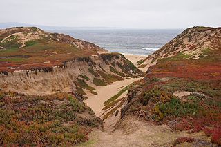
Fort Ord Dunes State Park is a state park of California, USA, along 4 miles (6.4 km) of coastline on Monterey Bay and created from part of the now-closed Fort Ord. The park includes a boardwalk, a path to the beach, a 4-mile (6.4 km) road for walking and biking, and interpretive exhibits describing its former use as a military training area. As the dunes are a nesting area for sensitive species, public access is limited to the paths and trails.

Aquatic Park Historic District is a National Historic Landmark and building complex located on the San Francisco Bay waterfront within San Francisco Maritime National Historical Park.

The Point Montara Light is a lighthouse in Montara, California, United States, on the southern approach to the San Francisco Bay, California approximately 25 miles south of San Francisco.
Caspar Headlands State Beach is a protected beach in the state park system of California, USA. It is located in Northern California in Mendocino County near the village of Caspar. The 75-acre (30 ha) park was established in 1972.

The San Francisco Bay National Estuarine Research Reserve is one of 27 reserves established as part of the United States National Estuarine Research Reserve System. The reserve is used to promote San Francisco Bay wetlands and estuary research, education, and stewardship.

The Cosco Busan oil spill occurred at 08:30 UTC-8 on 7 November 2007 between San Francisco and Oakland, California, in which 53,569 US gal (202,780 L) of IFO-380 heavy fuel oil, sometimes referred to as "bunker fuel", spilled into San Francisco Bay after the container ship Cosco Busan, operated by Fleet Management Ltd., struck Delta Tower of the San Francisco–Oakland Bay Bridge in thick fog.
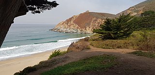
Gray Whale Cove State Beach is a California State Park between Pacifica, California, and Montara, California, by Highway 1 and approximately 18 miles south of San Francisco. It features a sheltered cove surrounded by abrupt cliffs, with trails connecting to nearby Montara Mountain and McNee Ranch State Park. It is located just south of Devil's Slide. The 3.1-acre (1.3 ha) park was established in 1966.