A campsite or camping pitch is a place used for overnight stay in an outdoor area. In British English, a campsite is an area, usually divided into a number of pitches, where people can camp overnight using tents, campervans or caravans; this British English use of the word is synonymous with the US English expression campground. In American English, the term campsite generally means an area where an individual, family, group, or military unit can pitch a tent or park a camper; a campground may contain many campsites.
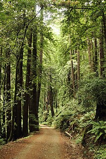
Butano State Park is a state park in the U.S. state of California, showcasing the secluded redwood-filled canyon of Little Butano Creek, a tributary of Butano Creek in the Pescadero Creek watershed. Located in San Mateo County near Pescadero, the 4,728-acre (1,913 ha) park was established in 1956.

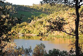
The Folsom Lake State Recreation Area surrounds Folsom Lake in the foothills of the Sierra Nevada, and is managed by the California Department of Parks and Recreation. It is located near the city of Folsom, California, about 25 miles (40 km) east of Sacramento.

The Conecuh National Forest in southern Alabama covers 83,000 acres (340 km2), along the Alabama - Florida line in Covington and Escambia counties. Topography is level to moderately sloping, broad ridges with stream terraces and broad floodplains.

Curecanti National Recreation Area(Pronounced or .) is a National Park Service unit located on the Gunnison River in western Colorado. Established in 1965, Curecanti National Recreation Area is responsible for developing and managing recreational facilities on three reservoirs, Blue Mesa Reservoir, Morrow Point Reservoir and Crystal Reservoir, constructed on the upper Gunnison River in the 1960s by the U.S. Bureau of Reclamation to better utilize the vital waters of the Colorado River and its major tributaries. A popular destination for boating and fishing, Curecanti offers visitors two marinas, traditional and group campgrounds, hiking trails, boat launches, and boat-in campsites. The state's premiere lake trout and Kokanee salmon fisheries, Curecanti is a popular destination for boating and fishing, and is also a popular area for ice-fishing in the winter months.
Crimson Lake Provincial Park is a provincial park located in Alberta, Canada, 14 kilometres (8.7 mi) west of Rocky Mountain House, off the David Thompson Highway along secondary highway 756.

Clear Creek State Park is a 1,211.19-acre (490.15 ha) Pennsylvania state park in Barnett and Heath Townships, Jefferson County, Pennsylvania in the United States. Public campsites were first opened at the park in 1922. Many of the facilities seen today at the park were constructed during the Great Depression by the Civilian Conservation Corps. Clear Creek State Park is 12 miles (19 km) from Brookville on Pennsylvania Route 949 at the confluence of Clear Creek and the Clarion River.

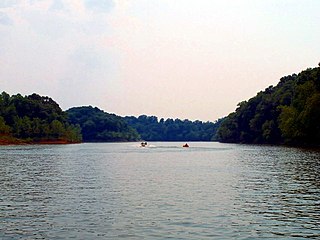
The San Luis Reservoir is an artificial lake on San Luis Creek in the eastern slopes of the Diablo Range of Merced County, California, approximately 12 mi (19 km) west of Los Banos on State Route 152, which crosses Pacheco Pass and runs along its north shore. It is the fifth largest reservoir in California. The reservoir stores water taken from the San Joaquin-Sacramento River Delta. Water is pumped uphill into the reservoir from the O'Neill Forebay which is fed by the California Aqueduct and is released back into the forebay to continue downstream along the aqueduct as needed for farm irrigation and other uses. Depending on water levels, the reservoir is approximately nine miles long from north to south at its longest point, and five miles (8 km) wide. At the eastern end of the reservoir is the San Luis Dam, or the B.F. Sisk Dam, the fourth largest embankment dam in the United States, which allows for a total capacity of 2,041,000 acre-feet (2,518,000 dam3). Pacheco State Park lies along its western shores.

Golden Ears Provincial Park is a Provincial park in British Columbia, Canada and is 555.9 square kilometres (214.6 sq mi). It is named after the prominent twin peaks which are commonly referred to as Golden Ears. The park's southern end is located on the northern edge of the district municipality of Maple Ridge on the north side of the Fraser River.

Cherry Lake is an artificial lake in the Stanislaus National Forest of Tuolumne County, California, U.S.A., about 25 miles (40 km) east of the city of Sonora. It is at an elevation of 4,700 feet (1,433 m) on the western side of the Sierra Nevada, and lies just outside the western boundary of Yosemite National Park. The lake has a capacity of 273,500 acre⋅ft (337,400,000 m3) and is formed by Cherry Valley Dam on Cherry Creek.

Peninsula State Park is a 3,776-acre (1,528 ha) Wisconsin state park with eight miles (13 km) of Green Bay shoreline in Door County. Peninsula is the third largest state park in Wisconsin and is visited by an estimated one million visitors annually.

Hills Creek State Park is a 407-acre (165 ha) Pennsylvania state park in Charleston Township, Tioga County, Pennsylvania in the United States. Hills Creek Lake, a 137-acre (55 ha) man-made lake, is the focal point of the park. It is open for year-round recreation. Hills Creek State Park is in the Allegheny Plateau region of Pennsylvania, just north of U.S. Route 6 near the boroughs of Wellsboro and Mansfield.
Poe Valley State Park is a 620-acre (251 ha) Pennsylvania state park in Penn Township, Centre County, Pennsylvania in the United States. The park is surrounded by Bald Eagle State Forest. Poe Paddy State Park is 4 miles (6.4 km) to the east. The forests of the park surround the 25-acre (10 ha) Poe Lake. Poe Valley State Park is in isolated Poe Valley which lies between Potters Mills on U.S. Route 322 and Millheim on Pennsylvania Route 45. The park was closed during the 2008 and 2009 season while the lake was drained for dam repairs and the park facilities were upgraded.

Chapman State Park is a 862-acre (349 ha) Pennsylvania state park in Pleasant Township, Warren County, Pennsylvania near Clarendon, in the United States. The man-made Chapman Lake covers 68 acres (28 ha) of the park. Chapman State Park is named in honor of Dr. Leroy E. Chapman. Dr. Chapman was a state senator from 1929 until 1963. He was part of several civic groups that pushed for the creation of a state park in Warren County. Chapman State Park, opened in 1951, is adjacent to Allegheny National Forest and State Game Land 29 just off U.S. Route 6.
The Rough River Lake is a Y-shaped reservoir located in Breckinridge, Hardin, and Grayson which are all about 70 miles southwest of Louisville one of Kentucky's major cities. This lake was created by the building of a dam beginning in 1955 and was completed in 1961, this dam is 89.3 miles above the connection between the Rough River and the Green River. The land and water along with the wildlife, fisheries, and recreational activities are all managed under the cooperation of the U.S. Army Corps of Engineers and the Commonwealth of Kentucky. There are many activities to do when visiting this lake but the primary attraction included the Rough River Dam State Resort Park.
Wolf Creek State Park is an Illinois state park on 25,300 acres (10,200 ha) in Shelby County, Illinois, United States.

Colt Creek State Park is a Florida State Park in Central Florida, 16 miles (26 km) north of Lakeland off of State Road 471. This 5,067 acre park nestled within the Green Swamp Wilderness Area and named after one of the tributaries that flows through the property was opened to the public on January 20, 2007. Composed mainly of pine flatwoods, cypress domes and open pasture land, this piece of pristine wilderness is home to many animal species including the American bald eagle, Southern fox squirrel, gopher tortoise, white-tailed deer, wild turkey and bobcat.
Brushy Creek State Recreation Area is a state park in Webster County, Iowa in the United States. With an area encompassing over 6,000 acres (24 km2), the facility is one of Iowa's largest public outdoor recreation areas.

Meadow Lake Provincial Park is a northern boreal forest provincial recreational park along the Waterhen and Cold Rivers in the Canadian province of Saskatchewan. The park was founded on 10 March 1959, is the largest provincial park in Saskatchewan, and encompasses over 25 lakes in an area of 1,600 square kilometres. The park was named Meadow Lake after the city of Meadow Lake and Meadow Lake. The city and the lake are not in the park and are located about 40 kilometres (25 mi) south-east of the nearest park entrance, which is about 5 kilometres (3.1 mi) north of Dorintosh. The length of the park stretches about 113 kilometres (70 mi) from Cold Lake on the Saskatchewan / Alberta border in the west to the eastern shore of Waterhen Lake in the east.
Lower Fishing Lake is a lake in the east-central part of the Canadian province of Saskatchewan in Narrow Hills Provincial Park. It is situated in the Cub Hills and the boreal forest ecozone of Canada. The lake is accessed from Highway 920, which connects to Hanson Lake Road and Highway 120. The Fishing Lakes Fire of 1977 burned much of the region upstream and around the lake and now the area is now dominated by jack pine, which is a tree species that is well adapted fire burned forests.