
Ventura County is a county in the southern part of the U.S. state of California. As of the 2010 census, the population was 823,318. The largest city is Oxnard, and the county seat is the city of Ventura.

Ventura, officially San Buenaventura, is the county seat of Ventura County, California, United States. The coastal site, set against undeveloped hills and flanked by two free-flowing rivers, has been inhabited for thousands of years. European explorers encountered a Chumash village, referred to as Shisholop, here while traveling along the Pacific coast. They witnessed the ocean navigation skill of the native people and their use of the abundant local resources from sea and land. In 1782, the eponymous Mission San Buenaventura was founded nearby, where it benefitted from the water of the Ventura River. The town grew around the mission compound and incorporated in 1866. The development of nearby oil fields in the 1920s and the age of automobile travel created a major real estate boom during which many designated landmark buildings were constructed. The mission and these buildings are at the center of a downtown that has become a cultural, retail, and residential district and visitor destination.

The Santa Clara River is 83 mi (134 km) long, and is one of the most dynamic river systems in Southern California. The river drains parts of four ranges in the Transverse Ranges System north and northwest of Los Angeles, then flows west onto the Oxnard Plain and into the Santa Barbara Channel of the Pacific Ocean.
Coyote Creek is a river that flows through the Santa Clara Valley in California, United States.

Emma Wood State Beach is a California State Beach in Ventura, California. It is located on the Santa Barbara Channel on the west side of the Ventura River estuary and south of the railroad tracks of the Coast Line and the US Highway 101 freeway.
Navarro River Redwoods State Park is a state park in Mendocino County, California, consisting of 660 acres (2.7 km2) of second-growth redwood forest in a narrow stretch 11 miles (18 km) long on both banks of the Navarro River, from the town of Navarro to the river's confluence with the Pacific Ocean.

Mandalay State Beach is a protected beach in the city of Oxnard, California, United States. Managed by the California Department of Parks and Recreation, the park preserves an area of undeveloped sand dunes and wetlands that was once common along the 16.5-mile-long (26.6 km) coastline of the Oxnard Plain.

The Ventura River, in western Ventura County in southern California, United States, flows 16.2 miles (26.1 km) from its headwaters to the Pacific Ocean. The smallest of the three major rivers in Ventura County, it flows through the steeply sloped, narrow Ventura Valley, with its final 0.7 miles (1.1 km) through the broader Ventura River estuary, which extends from where it crosses under a 101 Freeway bridge through to the Pacific Ocean.

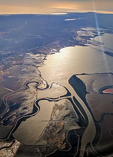
The Oxnard Plain is a large coastal plain in southwest Ventura County, California, United States surrounded by the mountains of the Transverse ranges. The cities of Oxnard, Camarillo, Port Hueneme and much of Ventura as well as the unincorporated communities of Hollywood Beach, El Rio, Saticoy, Silver Strand Beach, and Somis lie within the over 200-square-mile alluvial plain (520 km2). The population within the plain comprises a majority of the western half of the Oxnard-Thousand Oaks-Ventura Metro Area and includes the largest city along the Central Coast of California. The 16.5-mile-long coastline (26.6 km) is among the longest stretches of continuous, linear beaches in the state.

Point Mugu State Park is a state park located in the Santa Monica Mountains National Recreation Area in Southern California. The rugged, nearly impassible shoreline of the western Santa Monica Mountains gives way to tidal lagoons and coastal sand dunes at Mugu Rock. The western edge of the park adjoins Mugu Lagoon which is a protected area within Naval Air Station Point Mugu.

Pacifica State Beach is the southernmost of Pacifica, California's large beaches, it is a 0.75 mile long crescent shaped beach located at the mouth of the San Pedro Valley in downtown Pacifica off State Route 1, in San Mateo County.

Ventura station is a passenger rail station in downtown Ventura, California. The station is served by Amtrak's Pacific Surfliner from San Luis Obispo to San Diego. Ten Pacific Surfliner trains serve the station daily. Of the 73 California stations served by Amtrak, Ventura was the 33rd-busiest in FY2010, boarding or detraining an average of approximately 125 passengers daily. The single platform is located on the south side of the tracks with a view of the Santa Barbara Channel and the Channel Islands. The Ventura Freeway is parallel with and on the north side of tracks.

Russian River State Marine Recreational Management Area (SMRMA) and Russian River State Marine Conservation Area (SMCA) are two adjoining marine protected areas in the Russian River estuary area in Sonoma County, California, on the north-central coast of the state. The combined area of these marine protected areas is 1.21 square miles (3.1 km2), with 0.35 square miles (0.91 km2) in the SMRMA and 0.86 square miles (2.2 km2) in the SMCA.

The West Montalvo Oil Field is a large and productive oil field on the coast of Ventura County, California, in the United States, in and adjacent to the city of Oxnard, California. Discovered in 1947, it has produced approximately 43.7 million barrels (6,950,000 m3) of oil, and retains about 2.2 million recoverable with current technology, in both the onshore and offshore areas. The offshore portion of the field is exploited from wells directionally drilled from onshore near McGrath Lake, from within an enclosure above the high-tide line at McGrath State Beach.
Seaside Park is an event venue in Ventura, California, United States. The 62-acre site (25 ha) is the home of the Ventura County Fair. Trade shows, concerts, and other events are held throughout the year at the fairgrounds. The beachfront site, near the mouth of the Ventura River, also includes Surfers' Point, known for its point break that produces distinctive waves.

The Tijuana River Estuary is an intertidal coastal wetland at the mouth of the Tijuana River in San Diego County, California, in the United States bordering Tijuana, Baja California, Mexico. It is the location of the Tijuana River National Estuarine Research Reserve, Tijuana Slough National Wildlife Refuge, and Border Field State Park. The estuary is a shallow water habitat. Often termed an intermittent estuary since its volume is subject to the discharge controlled by the seasons of the year, the volume of the estuary fluctuates and at times there is dry land, or flooded areas. It was designated a National Natural Landmark in 1973.
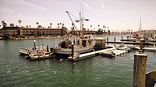
Channel Islands Harbor is a small craft harbor and shore-protection project in Oxnard, California at the southern end of the Santa Barbara Channel. It is the fifth largest harbor for small-craft recreation in the state of California and is a waterfront resort, recreation, and dining marketplace. Recreational activities include diving, boat charters, sea kayaking, sportfishing, and whale watching.

This timeline of the Portolá expedition tracks the progress during 1769 and 1770 of the first European exploration-by-land of north-western coastal areas in what became Las Californias, a province of Spanish colonial New Spain. Later, the region was administratively-split into Baja and Alta. The first section of the march was on the Baja California peninsula, and the northern section of the expedition's trail was in today's U.S.A. state of California.
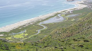
Mugu Lagoon is a salt marsh located within the Naval Base Ventura County at the foot of the Santa Monica Mountains in Ventura County, California. The lagoon extends for 4.3 miles parallel to a narrow barrier beach. The first European to come ashore here was Juan Rodríguez Cabrillo on October 10, 1542. Cabrillo was the first European to visit present-day California, and he named it Muwu, which is Chumash meaning "beach" or "seashore". When the Europeans first discovered the lagoon, it functioned as the capital village of the Chumash Indians settled around Point Mugu.
The Gaviota Coast in Santa Barbara County, California is a rural coastline along the Santa Barbara Channel roughly bounded by the city of Goleta and the north boundary of the county. This last undeveloped stretch of Southern California coastline consists of dramatic bluffs, isolated beaches and terraced grasslands.


