Mentryville, California

Last updated

Mentryville
Ghost town
C.A. Mentry House, Mentryville, California.jpg
C.A. Mentry House in 2008
Location map Santa Clarita.svg
Red pog.svg
Mentryville
USA California location map.svg
Red pog.svg
Mentryville
Coordinates: 34°22′44″N118°36′40″W / 34.379°N 118.611°W / 34.379; -118.611
CountryUnited States
StateCalifornia
County Los Angeles
Elevation
1,609 ft (490 m)
Time zone UTC-8 (PST)
  Summer (DST) UTC-7 (PDT)
Area code 661
Website www.scvhistory.com/mentryville/
Reference no.516-2 [1]

Mentryville was an oil drilling town in the Santa Susana Mountains in Los Angeles County, California, USA. It was started by Charles Alexander Mentry in the 1870s around the newly discovered oil reserves in that area. The first oil strike was on September 26, 1876. The town is located at the terminus of Pico Canyon Road, four miles west of the Lyons Avenue exit from I-5 in Santa Clarita. It is currently a part of Stevenson Ranch.

Contents

History

The town was named for Charles Alexander Mentry, the oil field superintendent from 1876 to 1900. Charles Alexander Mentry.jpg
The town was named for Charles Alexander Mentry, the oil field superintendent from 1876 to 1900.

Charles Alexander Mentry was born in France on March 27, 1847. In November, 1873 moved to San Francisco with his father, Peter Mentry. He moved to San Bernardino County to work at the Holcomb Valley Gold Mining Company. He moved back to San Francisco in 1874 for one year as a stock broker. In 1875 move to Grapevine Canyon and worked for Los Angeles Oil Company, drilling an oil well. He then went to work with J.G. Baker and D.C. Scott the Pico Oil claim. Mentry died in 1900 in Newhall. [2] D. G. Scofield Mentry and financing oil well of the Pico Canyon Oilfield. [3] [4] In 1875 Mentry partnered with Sanford Lyon, Henry Clay Wiley and Los Angeles lawman William Jenkins. [5]

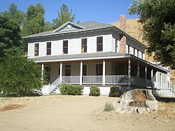
"Pico Number 4", a short distance up the canyon from Mentryville, was the first commercially successful oil strike in California , and the longest running well on record , finally being capped in 1990. The Pico Canyon oil field proved to be the richest in the state's history to that time, and Mentryville became a boomtown from 1876 to 1900. The town was named after the superintendent who was in charge of the oil field, Charles Alexander Mentry. Mentry lived in the town until his death in 1900 and built the 13-room mansion that still stands there. [6] [7] In 1900, the Los Angeles Times described Mentryville as "an ideal community of modest homes," where families were reared and a schoolhouse, social hall, bakery, boarding houses, bunkhouses, blacksmith shop and machine shop were built. [6] [7] There was also a gas-lighted tennis court, croquet fields, and a main road paved with local asphalt. [8] [9] One thing the town lacked was a bar. Mentry had reportedly "imbued the town with his puritanism as well as his name," prohibiting drinking and the use of foul language. [8] When Mentry died, the entire town of more than 200 people, [10] [11] except for three individuals left behind in Mentryville, traveled to Los Angeles for his funeral, bringing with them a large floral arrangement in the shape of an oil derrick. [6]

Mentryville was eventually abandoned, partially because the amount of oil slowed over time, and partially because of changes to the oil industry. During the 1930s, most of Mentryville's remaining residents left, many tearing down their houses board by board and nail by nail, and taking it all with them. [11] By 1962, Mentryville had become a ghost town, with only a caretaker family living in Mentry's old 13-room house. A visitor to the camp that year reported that "rusted oil equipment cluttered the canyon," toppled derricks lay rotting, and the cemetery was "choked with weeds, hidden and forgotten." [10]

Preservation

Felton Schoolhouse in 2008. The school was named in honor of Senator Charles N. Felton. Felton Schoohouse, Mentryville, California.jpg
Felton Schoolhouse in 2008. The school was named in honor of Senator Charles N. Felton.

The last caretaker of Mentryville was Francis "Frenchy" Lagasse, who moved into the old Mentry mansion with his wife and children in 1966. The property's owner, Standard Oil of California, wanted to raze the remnants of the ghost town, but Lagasse persuaded the company to allow him to restore the town. With help from the Santa Clarita Historical Society, Lagasse eventually began offering tours of Mentryville. [11] Lagasse was forced to leave Mentryville after the 1994 Northridge earthquake damaged the house, [8] and in 1995, Chevron (which had become the owner upon its acquisition of Standard Oil of California in 1977) donated the Mentryville site and the surrounding 800 acres (3.2 km2) in Pico Canyon to the Santa Monica Mountains Conservancy. [12] A group called the Friends of Mentryville was organized to restore the buildings and open the old town as a historic park with docent-led tours. [8]

The site is now registered as California Historical Landmark #516-2. [1]

A fire nearly destroyed Mentryville's historic structures in 2003, and a storm in 2004 washed out the visitors' parking lot and also flooded the historic buildings. [8]

Film and television productions

Mentryville and Pico Canyon have become popular shooting locations. They were used in motion pictures, including Steven Spielberg's "The Color Purple" and "Walking Tall Part 2", and in television series, including "The X-Files", "The A-Team", "Murder, She Wrote", and "Highway to Heaven.". [8] [11]

Mentryville is the subject of "Ghost Adventures" Season 26 Episode 5.

California Historical Landmark Marker

California Historical Landmark Marker No. 516–2 at the site reads:

NO. 516-2 MENTRYVILLE – Named after pioneer oil developer Charles Alexander Mentry, who in 1876 drilled the first successful oil well in California. His restored home and barn and Felton School remain here where the Star Oil Company, one of the predecessors of Standard Oil of California, was born. [13]

Nearby is state marker 516 for Well, CSO 4, the marker reads:

NO. 516 WELL, CSO 4 (PICO 4) – On this site stands CSO-4 (Pico No. 4), California's first commercially productive well. It was spudded in early 1876 under direction of Demetrious G. Scofield who later became the first president of Standard Oil Company of California, and was completed at a depth of 300 feet on September 26, 1876, for an initial flow of 30 barrels of oil a day. Later that year, after the well was deepened to 600 feet with what was perhaps the first steam rig employed in oil well drilling in California, it produced at a rate of 150 barrels a day – it is still producing after 77 years (1953). The success of this well prompted formation of the Pacific Coast Oil Company, a predecessor of Standard Oil Company of California, and led to the construction of the state's first refinery nearby. It was not only the discovery well of the Newhall Field, but was a powerful stimulus to the subsequent development of the California petroleum industry. [14]

See also

Related Research Articles

<span class="mw-page-title-main">Valencia, Santa Clarita, California</span> Neighborhood of Santa Clarita in Los Angeles County, California

Valencia is a neighborhood in Santa Clarita located within Los Angeles County, California. It is one of the four unincorporated communities that merged to create the city of Santa Clarita in 1987. It is situated in the western part of Santa Clarita, stretching from Lyons Avenue to the south to north of Copper Hill Drive, and from Interstate 5 east to Bouquet Canyon and Seco Canyon Roads. Valencia was founded as a master-planned community with the first development, Old Orchard I, built on Lyons Avenue behind Old Orchard Elementary School.

<span class="mw-page-title-main">Santa Susana Mountains</span> Mountain range of the Transverse Ranges in California, United States

The Santa Susana Mountains are a transverse range of mountains in Southern California, north of the city of Los Angeles, in the United States. The range runs east-west, separating the San Fernando and Simi valleys on its south from the Santa Clara River Valley to the north and the Santa Clarita Valley to the northeast. The Oxnard Plain is to the west of the Santa Susana Mountains.

<span class="mw-page-title-main">Santa Clarita Valley</span> Valley in Los Angeles County, California, United States

The Santa Clarita Valley (SCV) is part of the upper watershed of the Santa Clara River in Southern California. The valley was part of the 48,612-acre (19,673 ha) Rancho San Francisco Mexican land grant. Located in Los Angeles County, its main population center is the city of Santa Clarita which includes the communities of Canyon Country, Newhall, Saugus, and Valencia. Adjacent unincorporated communities include Castaic, Stevenson Ranch, Val Verde, and the unincorporated parts of Valencia.

<span class="mw-page-title-main">Newhall Pass</span> Mountain pass in Los Angeles County, California

Newhall Pass is a low mountain pass in Los Angeles County, California. Historically called Fremont Pass and San Fernando Pass, with Beale's Cut, it separates the Santa Susana Mountains from the San Gabriel Mountains. Although the pass was visited in August 1769 by Catalan explorer Gaspar de Portolá, it eventually was named for Henry Newhall, a significant businessman in the area during the 19th century.

<span class="mw-page-title-main">Stevenson Ranch, California</span> Unincorporated community in California, United States

Stevenson Ranch is an unincorporated community in the Santa Clarita Valley of Los Angeles County, California. Stevenson Ranch is set in the foothills of the Santa Susana Mountains and lies west of Interstate 5 and the city of Santa Clarita. Stevenson Ranch encompasses about 6.4 square miles (17 km2). About 1,000 acres (4.0 km2) are set aside as parks, recreation areas, and open space. A master-planned community, it was approved by the county in 1987. The population was 20,178 at the time of the 2020 census. For statistical purposes, the Census Bureau has designated it a census-designated place (CDP).

<span class="mw-page-title-main">Newhall, Santa Clarita, California</span> Community of Santa Clarita in California, United States of America

Newhall is the southernmost and oldest community in the city of Santa Clarita, California. Prior to the 1987 consolidation of Canyon Country, Saugus, Newhall, and Valencia into the city of Santa Clarita, it was an unincorporated area. It was the first permanent town in the Santa Clarita Valley.

The Newhall School District is an elementary school district in the Santa Clarita Valley that serves the Valencia and Newhall communities within the city of Santa Clarita, California, as well as the Stevenson Ranch community in unincorporated Los Angeles County. It currently includes ten schools.

<span class="mw-page-title-main">Santa Clarita, California</span> City in California, United States

Santa Clarita is a city in northwestern Los Angeles County in the U.S. state of California. With a 2020 census population of 228,673, it is the third-most populous city in Los Angeles County, the 17th-most populous in California, and the 103rd-most populous city in the United States. It is located about 30 miles (48 km) northwest of downtown Los Angeles, and occupies 70.75 square miles (183.2 km2) of land in the Santa Clarita Valley, along the Santa Clara River. It is a classic example of a U.S. edge city, satellite city, or boomburb.

<span class="mw-page-title-main">Newhall Land and Farming Company</span>

The Newhall Land and Farming Company is a land management company based in Valencia, Santa Clarita, California, United States. The company is responsible for the master community planning of Valencia and previously developed other areas such as Canyon Country and Newhall which together with Saugus and Valencia would merge to create the city of Santa Clarita in 1987. The company is also responsible for the management of farm land elsewhere in the state.

<span class="mw-page-title-main">Pico Canyon Oilfield</span> United States historic place

Well No. 4, Pico Canyon Oilfield, located about seven miles (11 km) west of Newhall, California, in the Santa Susana Mountains, was the first commercially successful oil well in the Western United States and is considered the birthplace of California's oil industry. Drilled in 1876, it turned nearby Newhall into a boomtown and also spawned a smaller boomtown called Mentryville adjacent to the drilling site. Well No. 4 continued in operation for 114 years until it was capped in 1990. The site was designated a National Historic Landmark in 1966, and the Mentryville ghost town is now open to the public as a historic park.

<span class="mw-page-title-main">Placerita Canyon State Park</span> State park in Los Angeles County, California, United States

Placerita Canyon State Park is a California State Park located on the north slope of the western San Gabriel Mountains, in an unincorporated rural area of Los Angeles County, near the city of Santa Clarita. The park hosts a variety of historic and natural sites, as well as serving as a trailhead for several hiking trails leading into the San Gabriel Mountains.

<span class="mw-page-title-main">D. G. Scofield</span> American businessman

Demetrius Gustavus Scofield was a pioneer of the oil business in California who founded a number of companies in that state and became the first president of Standard Oil of California.

<span class="mw-page-title-main">Valencia, California</span> Community in Los Angeles County, California, United States

Valencia is an unincorporated community in northwestern Los Angeles County, California, United States. The area, with major commercial and industrial parks, straddles State Route 126 and the Santa Clara River.

<span class="mw-page-title-main">Lyons Station Stagecoach Stop</span> Historical site in Newhall, Santa Clarita, California

The Lyons Station Stagecoach Stop,, was a tavern and stagecoach stop near the southwest corner of Newhall Avenue and Sierra Highway, by Eternal Valley Cemetery. The site is located in the present day Newhall section of Santa Clarita, in Los Angeles County, California.

<span class="mw-page-title-main">History of oil in California through 1930</span>

The story of oil production in California began in the late 19th century. In 1903, California became the leading oil-producing state in the US, and traded the number one position back-and forth with Oklahoma through the year 1930. As of 2022, California produced 3% of the crude oil of the nation, behind Texas, New Mexico, North Dakota, Alaska, Colorado, and Oklahoma. In the past century, California's oil industry grew to become the state's number one GDP export and one of the most profitable industries in the region. The history of oil in the state of California, however, dates back much earlier than the 19th century. For thousands of years prior to European settlement in America, Native Americans in the California territory excavated oil seeps. By the mid-19th century, American geologists discovered the vast oil reserves in California and began mass drilling in the Western Territory. While California's production of excavated oil increased significantly during the early 20th century, the accelerated drilling resulted in an overproduction of the commodity, and the federal government unsuccessfully made several attempts to regulate the oil market.

<span class="mw-page-title-main">Honor Rancho Oil Field</span> Oil and natural gas field adjacent to Santa Clarita, California, United States

The Honor Rancho Oil Field is an approximately 600-acre oil field and natural gas storage facility in Los Angeles County, California, on the northern border of the Valencia neighborhood of Santa Clarita, near the junction of Interstate 5 and westbound California State Route 126. Discovered in 1950 and quickly developed, the field's oil production peaked in the 1950s, but remains productive in 2016. In 1975 Southern California Gas Company (SoCalGas), the gas utility serving Southern California, began using one of its depleted oil producing zones, the Wayside 13 zone, as a gas storage reservoir, and it became the second-largest in their inventory after the Aliso Canyon gas storage facility. The field shares part of its extent with the Peter J. Pitchess Detention Center, which includes a maximum-security prison.

<span class="mw-page-title-main">Lang Southern Pacific Station</span> Historic site in Los Angeles County, California

Lang Southern Pacific Station is a former Southern Pacific railway station located in Soledad Canyon near the eastern end of Santa Clarita, California. On September 5, 1876, the first railway to Los Angeles was completed at this site. The Lang Southern Pacific Station was designated a California Historic Landmark on May 22, 1957.

<span class="mw-page-title-main">Old Santa Monica Forestry Station</span> Experimental forestry station

The Old Santa Monica Forestry Station is the nation's first experimental forestry station, built in 1887. The Old Santa Monica Forestry Station was designated a California Historic Landmark (No.840) on March 20, 1970. Old Santa Monica Forestry Station is located at Rustic Canyon in Los Angeles in the Santa Monica Mountains of Southern California in Los Angeles County. The site is south of what is now called Santa Monica Mountains National Recreation Area. In 1971 the state placed a marker near the entrance of the Rustic Canyon Recreation Center at the NW corner of Latimer and Hilltree Roads, at 601 Latimer Road, Los Angeles, CA 90402. This location is in what is now called Pacific Palisades. The hills and canyons around the Santa Monica Canyon were a land boom in the late 1880s.

<span class="mw-page-title-main">Pioneer Oil Refinery</span> Historical landmark in Santa Clarita, California

The Pioneer Oil Refinery was the first successful oil refinery in California, built in 1876 off Pine Street in Newhall, Santa Clarita, California. The Pioneer Oil Refinery was designated a California Historic Landmark (No.172) on March 6, 1935. Pioneer Oil Refinery is the oldest existing refinery in the world. The Lang Southern Pacific Station railroad line served the refinery. In 2020, the refinery was added to the National Register of Historic Places; it is the only site on the National Register of Historic Places within the city of Santa Clarita.

<span class="mw-page-title-main">Santa Clarita Woodlands Park</span> Open space preserve in Los Angeles County, California

Santa Clarita Woodlands Park is a 4,000 acre open space preserve located in the northeastern foothills of the Santa Susana Mountains near Santa Clarita, California.

References

  1. 1 2 "California Historic Landmarks – Los Angeles County". Office of Historical Preservation, California State Parks. Retrieved October 8, 2012.
  2. C.A. (Charles Alexander) Mentry. Pen Pictures From the Garden of the World: An Illustrated History of Los Angeles County, Calif. Chicago: The Lewis Publishing Co., 1889
  3. The Pioneer Refinery in the early 1880s
  4. Marker database First Commercial Oil Well In California, Pico #4
  5. Mr. & Mrs. Charles Alexander Mentry, Pico Canyon
  6. 1 2 3 "C.A. Mentry's Funeral: Remains of the Pioneer Oil Man Laid to Rest in Evergreen by His Masonic Brethren". Los Angeles Times. October 8, 1900.
  7. 1 2 "Influential Career: Facts About the Life and Work of the Late Charles Alexander Mentry, a 'Self-Made Man'". Los Angeles Times. October 20, 1900.
  8. 1 2 3 4 5 6 Cecilia Rasmussen (January 29, 2006). "L.A. Then and Now: After Oil Boomtown's Bust, Nature Added Its Blows". Los Angeles Times.
  9. Richard Kahlenberg (October 6, 2000). "Valley Life; jaunts; Back to the Boom; Mentryville Harvest Festival gives visitors the story of a once-prosperous oil town". Los Angeles Times.
  10. 1 2 Charles Hillinger (April 23, 1962). "Ghost Town Memento to Oil Field's Past: Only One Family Lives in Mentryville, Where the California Oil Industry Was Born". Los Angeles Times.
  11. 1 2 3 4 Debra Sorrentino Larson (May 22, 1986). "Mentryville State Landmark a Ghost of Once-Bustling Oil Town". Los Angeles Times. ("During its heyday around the turn of the [20th] century, about 100 families lived in Mentryville. No precise figures exist on how many people lived there, but some families had up to a dozen children.")
  12. Nicholas Grudin (August 3, 2003). "Ghosts of an Era: Mentryville Is a Monument to Both the Start and Decline of the Area's Oil Drilling Industry". Daily News (Los Angeles).
  13. "CHL # 516.2 Mentryville Los Angeles". www.californiahistoricallandmarks.com. Retrieved August 29, 2019.
  14. "CHL # 516 Well, CSO 4 Los Angeles". www.californiahistoricallandmarks.com. Retrieved August 29, 2019.