
Culver City is a city in Los Angeles County, California. As of the 2020 census, the population was 40,779. Founded in 1917 as a "whites only" sundown town, it is now an ethnically diverse city with what was called the "third-most diverse school district in California" in 2020.

Marina del Rey is an unincorporated seaside community in Los Angeles County, California, with an eponymous harbor that is a major boating and water recreation destination of the greater Los Angeles area. The port is North America's largest man-made small-craft harbor and is home to approximately 5,000 boats. The area is a popular tourism destination for both land and water activities such as paddle board and kayak rentals, dining cruises, and yacht charters. Land activities include bicycling on several bicycle paths, walking paths along the waterfront, and birdwatching (birding). Wildlife watching opportunities include California sea lions and harbor seals. Dolphins and whales occasionally visit the deeper waters of harbor. This Westside locale is approximately 4 miles (6.4 km) south of Santa Monica, 4 miles (6.4 km) north of Los Angeles International Airport, and 12.5 miles (20.1 km) west-southwest of Downtown Los Angeles.

Playa del Rey is a seaside community in the Santa Monica Bay and the Westside region of Los Angeles, California. It has a ZIP code of 90293 and area codes of 310 and 424. As of 2018, the community had a population of 16,230 people.
The Los Angeles Westside is an urban region in western Los Angeles County, California. It has no official definition, but sources like LA Weekly and the Mapping L.A. survey of the Los Angeles Times place the region on the western side of the Los Angeles Basin south of the Santa Monica Mountains.

Mar Vista is a neighborhood on the Westside of Los Angeles, California. In 1927, Mar Vista became the 70th community to be annexed to Los Angeles. It was designated as an official city neighborhood in 2006.

Playa Vista is a neighborhood in the Westside area of Los Angeles, California. The area was the headquarters of Hughes Aircraft Company from 1941 to 1985 and the site of the construction of the Hughes H-4 Hercules "Spruce Goose" aircraft. The area began development in 2002 as a planned community with residential, commercial, and retail components. The community attracted businesses in technology, media and entertainment and, along with Santa Monica and Venice, Marina del Rey, Playa del Rey, Culver City, El Segundo and Mar Vista, has become known as Silicon Beach.

Del Rey is a neighborhood in the Westside of Los Angeles, surrounded on three sides by Culver City, California. Within it lie a police station, the largest public housing complex on the Westside, a public middle school and six public elementary schools. It is served by a neighborhood council and a residents association. Del Rey, with a 32,000+ population, has a large number of military veterans.

Ballona Creek is an 8.5-mile (13.7 km) channelized stream in southwestern Los Angeles County, California, United States, that was once a “year-round river lined with sycamores and willows.” Ballona Creek and neighboring Ballona Wetlands remain a prime bird-watching spot for waterfowl, shorebirds, warblers, and birds of prey.
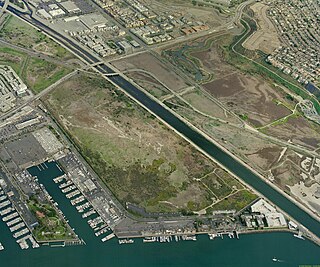
Ballona Wetlands Ecological Reserve is a protected area that once served as the natural estuary for neighboring Ballona Creek. The 577 acres (2.34 km2) site is located in Los Angeles County, California, just south of Marina del Rey. Ballona—the second-largest open space within the city limits of Los Angeles, behind Griffith Park—is owned by the state of California and managed by the California Department of Fish and Wildlife. The preserve is bisected generally east-west by the Ballona Creek channel and bordered by the 90 Marina freeway to the east.

Washington Boulevard is an east-west arterial road in Los Angeles County, California spanning a total of 27.4 miles (44 km).
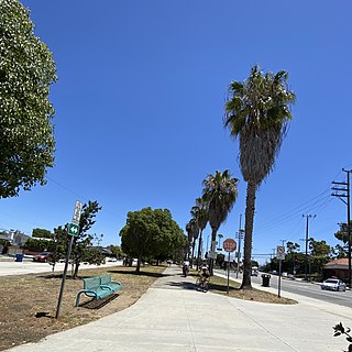
The Culver Boulevard Median Bike Path is Class I rail trail bicycle path, walk route and linear park on Culver Boulevard in western Los Angeles County, California.
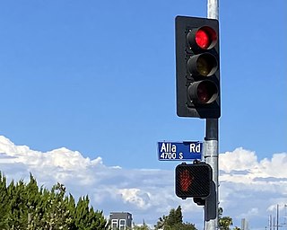
Alla is a former streetcar station and archaic place name located near Marina del Rey in the Westside region of Los Angeles County, California.

Alsace is an archaic place name. Originally an interurban trolley stop, the name now informally designates an approximately five-block area of unincorporated Los Angeles County in the Westside region, surrounded by the north-of-Jefferson section of Playa Vista, Los Angeles, California.

Machado is a former settlement in Los Angeles County, California. It lay at an elevation of 13 feet.
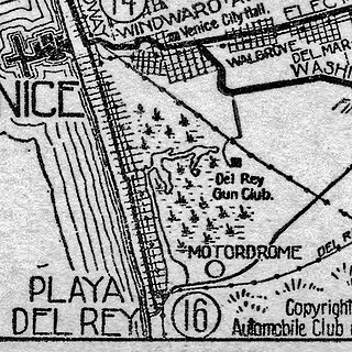
Motordrome is an archaic placename in Los Angeles County, California. It was a rail spur in the 1910s on the Redondo Beach via Del Rey Line, named for the Los Angeles Motordrome race track and airplane hangar.

The Los Angeles Pacific Railroad (1896−1911) (LAP) was an electric public transit and freight railway system in Los Angeles County, California. At its peak it had 230 miles (370 km) of track extending from Downtown Los Angeles to the Westside, Santa Monica, and the South Bay towns along Santa Monica Bay.
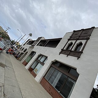
The Dickinson and Gillespie Building, is located at 200 Culver Boulevard in downtown Playa Del Rey, California, in the City of Los Angeles. This two-story commercial building, created in 1922, was an extensive remodel of the Hotel Playa, a hotel opened in 1906 on the same site.

The Venice–Inglewood Line is a former Pacific Electric interurban railway line in Los Angeles County, California. Service was very sparse, providing a suburban route between Venice and Inglewood.

The Redondo Beach via Playa del Rey was an interurban railway route of the Pacific Electric. It operated between the Hill Street Terminal and Cliffton, south of Redondo Beach, through the company's Western Division.
Culver Boulevard is an east-west thoroughfare in the Westside region of Los Angeles County, California, connecting Venice Boulevard to the coast roads.
 Venice Del Rey Land and Water Company advertisement, 1905, inviting buyers to inspect lots near the Cypress Grove stop of the Playa Del Rey Line
 Cypress Grove visible on 1912 map of PE system
 Cypress Grove on 1923 USGS map of Venice quadrangle; Speedway was an early name for what is now Culver Boulevard


