Related Research Articles

Los Angeles County, officially the County of Los Angeles and sometimes abbreviated as L.A. County, is the most populous county in the United States, with 9,663,345 residents estimated in 2023. Its population is greater than that of 40 individual U.S. states. Comprising 88 incorporated cities and many unincorporated areas within a total area of 4,083 square miles (10,570 km2), it is home to more than a quarter of Californians and is one of the most ethnically diverse U.S. counties. The county's seat, Los Angeles, is the second most populous city in the United States, with 3,820,914 residents estimated in 2023. The county has been world-renowned as the domicile of the U.S. motion picture industry since the latter's inception in the early 20th century.

El Monte is a city in Los Angeles County, California, United States. The city lies in the San Gabriel Valley, east of the city of Los Angeles.
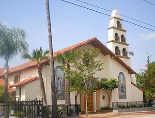
San Fernando is a general-law city in the San Fernando Valley region of Los Angeles County, California, in the Los Angeles metropolitan area. It is an enclave in the City of Los Angeles. As of the 2020 census the population of San Fernando was 23,946.

Mission Hills is a neighborhood in Los Angeles, California, located in the San Fernando Valley.

Chatsworth is a suburban neighborhood in Los Angeles, California, in the San Fernando Valley.
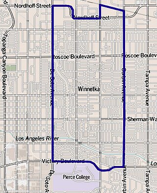
Winnetka is a neighborhood in the west-central San Fernando Valley in the city of Los Angeles. It is an ethnically diverse area, both for the city and for Los Angeles County, with a relatively large percentage of Hispanic and Asian people.
Panorama City is a neighborhood in the city of Los Angeles, California, in the San Fernando Valley. It has a generally young age range as well as the highest population density in the Valley. More than half of the neighborhood's population was born abroad, the majority being from Mexico. Known as the Valley's first planned community after a transition from agriculture to a post-World War II housing boom, it has been home to several notable residents. It is now a mixture of single-family homes and low-rise apartment buildings.
The Los Angeles Westside is an urban region in western Los Angeles County, California, United States. It has no official definition, but sources like LA Weekly and the Mapping L.A. survey of the Los Angeles Times place the region on the western side of the Los Angeles Basin south of the Santa Monica Mountains.

State Route 118 is a state highway in the U.S. state of California that runs west to east through Ventura and Los Angeles counties. It travels from State Route 126 at the eastern edge of Ventura immediately northwest of Saticoy, then through Saticoy, in Ventura County east to Interstate 210 near Lake View Terrace in Los Angeles. SR 118 crosses the Santa Susana Pass and the northern rim of the San Fernando Valley along its route.

Glassell Park is a neighborhood of Northeast Los Angeles, California, in the San Rafael Hills.
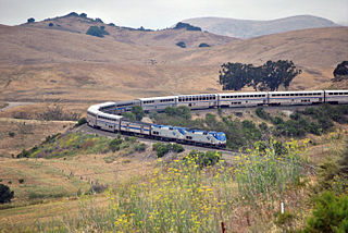
The Coast Line is a railroad line between Burbank, California and the San Francisco Bay Area, roughly along the Pacific Coast. It is the shortest rail route between Los Angeles and the Bay Area. Though not as busy as the Surf Line, the continuation of the Coast Line southbound to San Diego, it still sees freight movements and lots of passenger trains. The Pacific Surfliner, which runs from the San Diego Santa Fe Depot to San Luis Obispo via Union Station in Los Angeles, is the third busiest Amtrak route, and the busiest outside of the Northeast Corridor between Washington D.C. and Boston.

California's 29th congressional district is a congressional district in the U.S. state of California based in the north central San Fernando Valley. The district is represented by Democrat Tony Cárdenas.
Wilmar was the former name of a then-unincorporated district of San Gabriel Township in the San Gabriel Valley, about eight miles east of the center of Los Angeles. In the 1940 census, Wilmar had a population of 11,590. Wilmar was combined with the unincorporated communities of Garvey and Potrero Heights to become the unincorporated community of South San Gabriel in the early 1950s. It was named for the city of Wilmar, Arkansas by "Arkies" who migrated to the area as a rural counterpart to their roots in Arkansas.

Santa Susana Pass State Historic Park is a California State Park of 670.68 acres (2.7141 km2) located in the city of Los Angeles, in Los Angeles County on the boundary between Ventura and Los Angeles counties, between the communities of Chatsworth and Simi Valley. Geologically, the park is located where the Simi Hills meet the Santa Susana Mountains. Here in the western part of the Transverse Ranges, the land is dominated by high, narrow ridges and deep canyons covered with an abundant variety of plant life. The park offers panoramic views of the rugged natural landscape as a striking contrast to the developed communities nearby. The park is also rich in archaeological, historical, and cultural significance.

Annandale is a former community in Los Angeles County, California that is now a neighborhood in Los Angeles, California and Pasadena, California. The Pasadena portion is bordered by Colorado Boulevard to the north, San Rafael Avenue to the east, and the Pasadena-Los Angeles border to the south and west. The Los Angeles portion is approximately bordered by Meridian Street, Figueroa Street, Colorado Blvd and the Pasadena-Los Angeles border. The main roads through the neighborhood are Figueroa Street, Avenue 64 and La Loma Road.

Northeast Los Angeles is a 17.18 sq mi (44.5 km2) region of Los Angeles County, comprising seven neighborhoods within Los Angeles. The area is home to Occidental College located in Eagle Rock.

Owensmouth was a town founded in 1912 in the western part of the San Fernando Valley in Los Angeles County, California. Owensmouth joined the city of Los Angeles in 1917, and was renamed Canoga Park on March 1, 1931. Owensmouth was named for the 1913 Owens River aqueduct's terminus in current Canoga Park.
San Jose Township was a township in Los Angeles County, California. It existed prior to the abolition of townships in California, and appeared as a subdivision of Los Angeles County in the 1860, 1870 and 1880 U.S. Censuses. Its area encompassed Rancho San Jose, the eastern portions of the county drained by San Jose Creek, including what is now the cities of Pomona, Claremont and Walnut. In 1880, it was recorded as having 1170 residents - which made it one of the smallest townships in Los Angeles County, but nevertheless a sizable settlement in the region, larger than Bakersfield and slightly smaller than Riverside
Tejon Township was a defunct township in Los Angeles County, California. It existed prior to the abolition of townships in California in the 1870s. By far the largest of the county's townships, it encompassed an area from the San Gabriel and Santa Susana Mountains in the south to the Tulare County line in the north. It was centered on Fort Tejon. In 1860, the township had a population of 920.
Soledad Township was a defunct township in Los Angeles County, California. It existed prior to the abolition of townships in California. It was formed in 1866 when Tejon Township was divided between Los Angeles and the new Kern County. Soledad Township was the county's most extensive but least populated township. It stretched from the San Gabriel and Santa Susana Mountains to the Kern County line and was centered on Soledad Canyon. In 1870, the township had a population of 265.
References
- ↑ Paul R. Spitzzeri (Fall 2007). "What a Difference a Decade Makes: Ethnic and Racial Demographic Change in Los Angeles County during the 1860s" (PDF). Branding Iron.
- ↑ U.S. Census Bureau. "Population of the United States in 1860: California" (PDF).