
The Los Angeles Community College District (LACCD) is the community college district serving Los Angeles, California, and some of its neighboring cities and certain unincorporated areas of Los Angeles County. Its headquarters are in Downtown Los Angeles. Over the past seventy-seven years, LACCD has served as educator to more than three million students. In addition to typical college aged students, the LACCD also serves adults of all ages: over half of all LACCD students are older than 25 years of age, and more than a quarter are 35 or older. LACCD educates almost three times as many Latino students and nearly four times as many African-American students as all of the University of California campuses combined. Eighty percent of LACCD students are from underserved populations. The Los Angeles Community College District is the largest community college district in the United States and is one of the largest in the world. The nine colleges within the district offer educational opportunities to students in Los Angeles. It serves students located in the Alhambra, Beverly Hills, Burbank, Culver City, Garvey, Las Virgenes, Los Angeles, Montebello, Palos Verdes and San Gabriel school districts. The district covers the Los Angeles city limits, San Fernando, Calabasas, Agoura Hills, Hidden Hills, Burbank, West Hollywood, Beverly Hills, Culver City, Alhambra, Monterey Park, San Gabriel, Rosemead, Montebello, Commerce, Vernon, Huntington Park, Bell, Cudahy, Bell Gardens, South Gate, Gardena, Carson, Lomita, Palos Verdes Estates, Rolling Hills, Rancho Palos Verdes, and numerous unincorporated communities, including East Los Angeles, Florence-Firestone, Athens, and Walnut Park. The LACCD consists of nine colleges and covers an area of more than 882 square miles (2,280 km2).
East Pasadena is an unincorporated community in Los Angeles County, California, United States. The population was 6,021 at the 2020 census, down from 6,144 at the 2010 census. For statistical purposes, the United States Census Bureau has defined East Pasadena as a census-designated place (CDP).
Monterey Park is a city in the western San Gabriel Valley region of Los Angeles County, California, United States, approximately seven miles (11 km) east of the Downtown Los Angeles civic center. It is bordered by Alhambra, East Los Angeles, Montebello and Rosemead. The city's motto is "Pride in the past, Faith in the future".

Rosemead is a city in Los Angeles County, California, United States. The 2020 United States Census reported a population of 51,185. Rosemead is part of a cluster of cities, along with Alhambra, Arcadia, Temple City, Monterey Park, San Marino, and San Gabriel, in the west San Gabriel Valley with a growing Asian-American population.
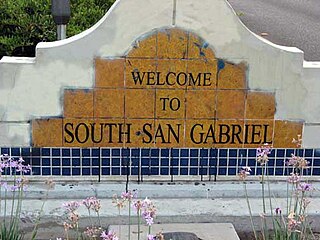
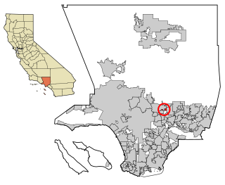
South San Gabriel is a census-designated place (CDP) in Los Angeles County, California, United States. The population was 8,070 at the 2010 census, up from 7,595 at the 2000 census.

The San Gabriel Valley, often referred to by its initials as SGV, is one of the principal valleys of Southern California, with the city of Los Angeles directly bordering it to the west, and occupying the vast majority of the southeastern part of Los Angeles County. Surrounding landforms and other features include the following:

Mar Vista is a neighborhood on the Westside of Los Angeles, California. In 1927, Mar Vista became the 70th community to be annexed to Los Angeles. It was designated as an official city neighborhood in 2006.

Hastings Ranch is a neighborhood of Pasadena, California, which lies in northeast Pasadena. It is principally accessed by Sierra Madre Boulevard, Michillinda Avenue, Hastings Ranch Blvd., and Riviera Drive. Hastings Ranch is also identified by large shopping areas at its southernmost end and by a shopping center at the corner of Sierra Madre and Michillinda. Hastings Ranch is divided by Sierra Madre Blvd, north of the blvd is Upper Hastings Ranch and south is Lower Hastings Ranch. To the north of the Ranch are the San Gabriel Mountains and Mount Wilson.

The Asian American influx into the southwestern portion of the San Gabriel Valley region of Los Angeles County, California, grew rapidly when Chinese immigrants began settling in Monterey Park in the 1970s. Just east of the city of Los Angeles, the region has achieved international prominence as a hub of overseas Chinese, or hua qiao. Although Chinese immigrants were a noteworthy presence in the establishment of Southern California from the 19th century, significant Chinese migration to suburban San Gabriel Valley coincided with a trend of white out-migration from the 1970s onward. This opened an opportunity for middle-class Asian Americans to begin settling in the San Gabriel Valley.
San Gabriel Unified School District, also known as SGUSD, is a public school district that serves the community of San Gabriel, California. It is located in the San Gabriel Valley area. SGUSD separated itself from the Alhambra Unified School District. This is a rather small district which has only one middle school and one high school. Del Mar High is a continuation school which provides service to the students who have discipline and/or grade problems or are behind credits to graduation.
Montebello Unified School District is a school district based in Montebello, California, United States.

3rd Street in Los Angeles is a major east–west thoroughfare. The west end is in downtown Beverly Hills by Santa Monica Boulevard, and the east is at Alameda Street in downtown Los Angeles, where it shares a one-way couplet with 4th Street. East of Alameda it becomes 4th Street, where it heads to East Los Angeles, where it turns back into 3rd Street upon crossing Indiana Street. 3rd Street eventually becomes Pomona Boulevard in Monterey Park, where it then turns into Potrero Grande Drive and finally turns into Rush Street in Rosemead and ends in El Monte.
Valley Boulevard is a street in Southern California, running east from Los Angeles to Pomona, where it becomes Holt Avenue, and a continuation from Fontana to Colton. It generally parallels Interstate 10 (I-10) and State Route 60 (CA 60), and is the original alignment of U.S. Route 60 (US 60). The present north end of I-710 is at Valley Boulevard in Los Angeles, just west of Alhambra.
Garvey School District is a pre-K-8 school district with headquarters located in the city of Rosemead, California. It operates nine pre-K-6 elementary schools, one pre-K-8 elementary school and two intermediate schools. The district serves more than 6000 students from diverse backgrounds, predominantly Asian and Latin American.
Garvey Avenue is a west-east thoroughfare in the San Gabriel Valley. It is named after Richard Garvey Sr., a former postal horse rider and ranch owner who donated part of his land to create the thoroughfare, which became an important link between Los Angeles and the San Gabriel Valley, especially prior to the establishment of the Interstate Highway System.

Annandale is a former community in Los Angeles County, California that is now a neighborhood in Los Angeles, California and Pasadena, California. The Pasadena portion is bordered by Colorado Boulevard to the north, San Rafael Avenue to the east, and the Pasadena-Los Angeles border to the south and west. The Los Angeles portion is approximately bordered by Meridian Street, Figueroa Street, Colorado Blvd and the Pasadena-Los Angeles border. The main roads through the neighborhood are Figueroa Street, Avenue 64 and La Loma Road.

Lamanda Park is a neighborhood in Pasadena, California. It is bordered roughly by Foothill Boulevard to the north, Del Mar Boulevard to the south, the Eaton Wash to the east, and Allen Avenue to the west, with a panhandle extending south along the western bank of the Eaton Wash. Like Annandale, it was originally a small township that was gradually enveloped by Pasadena. It was annexed in 1920. Even today, many commercial enterprises and newspapers still identify the area as a separate community.

Garfield Avenue ' is a major north-south street in Los Angeles County, California, US.
Rancho Potrero Grande is a 4,432-acre (17.94 km2) Mexican land grant in present-day Los Angeles County, California given in 1845 by Governor Pío Pico to Manuel Antonio. The name means "Large Pasture". The grant encompassed present-day Rosemead and South El Monte.

Mission Road is a major north-east south-west arterial street in the city of Los Angeles. It serves primarily as an alternative route to get to and from the Downtown Los Angeles area and the San Gabriel Valley. Part of the road is considered a portion of El Camino Real.