Motordrome, California

Last updated
Playa del Rey Motordrome location on USGS Map CA Venice 1934 Playa del Rey Motordrome Location on USGS Map CA Venice 301113 1934 24000 geo.jpg
Playa del Rey Motordrome location on USGS Map CA Venice 1934
Motordrome precise location based on Army Corps of Engineers aerial photo from 1950s Playa del Rey Motordrome Precise Location, Railroad Tracks.jpg
Motordrome precise location based on Army Corps of Engineers aerial photo from 1950s
Motordrome on an Auto Club map, 1914 Motordrome 1914.jpg
Motordrome on an Auto Club map, 1914

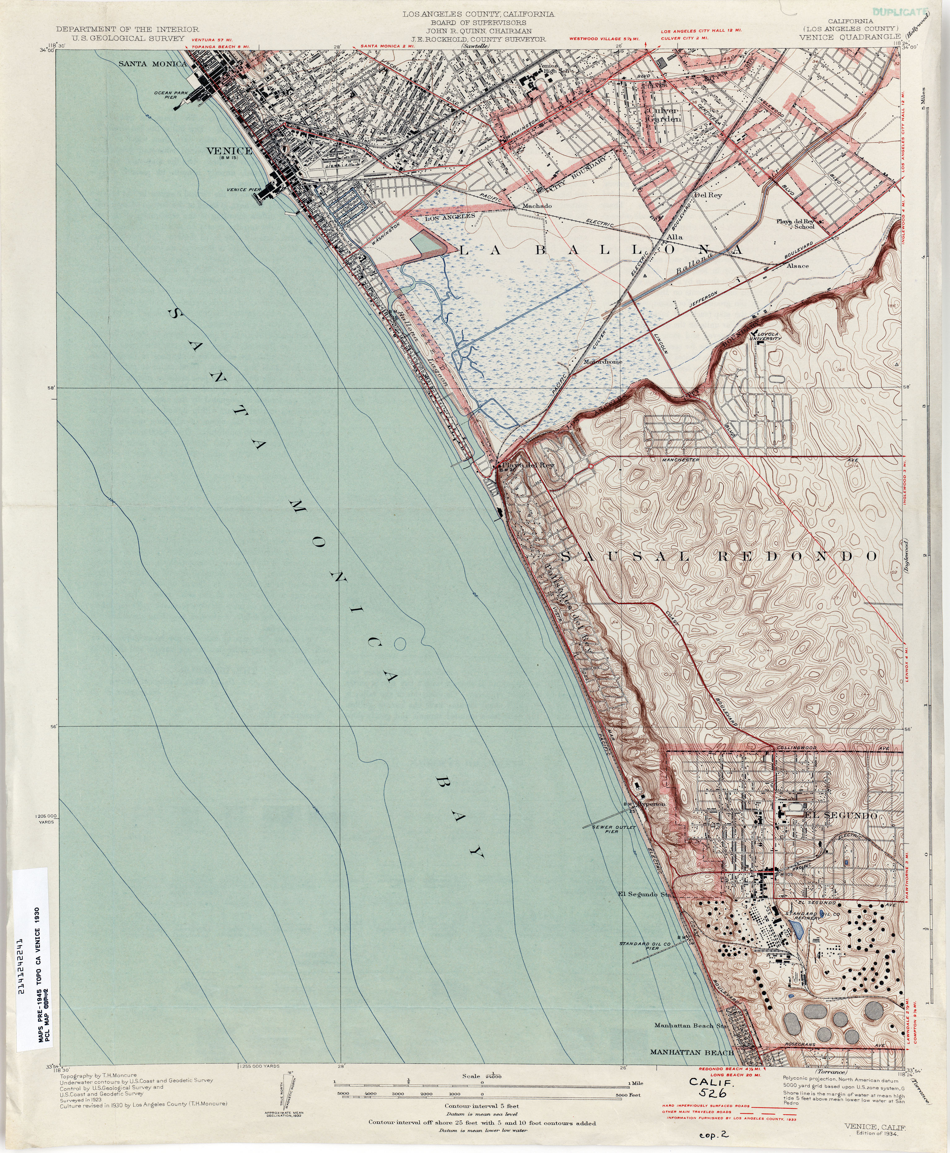
Motordrome is an archaic placename in Los Angeles County, California. [1] It designates a rail spur that existed in the 1910s [2] on the Redondo Beach via Del Rey Line, named for the Los Angeles Motordrome race track and airfield. [3]

Contents

Even though the racetrack was destroyed in a fire in 1913, and the rails were removed by 1918, [2] the place name persisted on USGS survey maps until at least the 1930s. [4]

The Barnes Circus train partially derailed at Motordrome in 1914, injuring four. [5]

Motordrome station lay at an elevation of 7 feet (2 m). [1]

The coordinates for Motordrome preserved in the GNIS ( 33°58′07″N118°26′21″W / 33.96861°N 118.43917°W / 33.96861; -118.43917 ) place it near the present-day intersections of Jefferson Boulevard and Culver Boulevard, in what is now the Ballona Wetlands Ecological Reserve.

Opening races of Los Angeles Motordrome pictured in Bystander magazine (1910) Motordrome photo in the Bystander magazine.jpg
Opening races of Los Angeles Motordrome pictured in Bystander magazine (1910)
Motordrome on 1913 Pacific Electric route map Location of Motordrome stop (California geographic place name).jpg
Motordrome on 1913 Pacific Electric route map

See also

Related Research Articles

<span class="mw-page-title-main">Marina del Rey, California</span> Unincorporated community in the United States

Marina del Rey is an unincorporated seaside community in Los Angeles County, California, with an eponymous harbor that is a major boating and water recreation destination of the greater Los Angeles area. The port is North America's largest man-made small-craft harbor and is home to approximately 5,000 boats. The area is a popular tourism destination for both land and water activities such as paddle board and kayak rentals, dining cruises, and yacht charters. Land activities include bicycling on several bicycle paths, walking paths along the waterfront, and birdwatching (birding). Wildlife watching opportunities include California sea lions and harbor seals. Dolphins and whales occasionally visit the deeper waters of harbor. This Westside locale is approximately 4 miles (6.4 km) south of Santa Monica, 4 miles (6.4 km) north of Los Angeles International Airport, and 12.5 miles (20.1 km) west-southwest of Downtown Los Angeles.

<span class="mw-page-title-main">Playa del Rey, Los Angeles</span> Neighborhood of Los Angeles in California, United States

Playa del Rey is a seaside community in the Santa Monica Bay and the Westside region of Los Angeles, California. It has a ZIP code of 90293 and area codes of 310 and 424. As of 2018, the community had a population of 16,230 people.

The Los Angeles Westside is an urban region in western Los Angeles County, California, United States. It has no official definition, but sources like LA Weekly and the Mapping L.A. survey of the Los Angeles Times place the region on the western side of the Los Angeles Basin south of the Santa Monica Mountains.

North Hills, known previously as Sepulveda, is a neighborhood in the San Fernando Valley region of Los Angeles, California.

<span class="mw-page-title-main">Mar Vista, Los Angeles</span> Neighborhood of Los Angeles in California, United States of America

Mar Vista is a neighborhood on the Westside of Los Angeles, California. In 1927, Mar Vista became the 70th community to be annexed to Los Angeles. It was designated as an official city neighborhood in 2006.

<span class="mw-page-title-main">Playa Vista, Los Angeles</span> Neighborhood of Los Angeles in California, United States

Playa Vista is a neighborhood in the Westside area of Los Angeles, California. The area was the headquarters of Hughes Aircraft Company from 1941 to 1985 and the site of the construction of the Hughes H-4 Hercules "Spruce Goose" aircraft. The area began development in 2002 as a planned community with residential, commercial, and retail components. The community attracted businesses in technology, media and entertainment and is part of Silicon Beach.

<span class="mw-page-title-main">Ballona Creek</span> Urbanized river in Los Angeles, California, United States.

Ballona Creek is an 8.5-mile (13.7 km) channelized stream in southwestern Los Angeles County, California, United States, that was once a "year-round river lined with sycamores and willows" with the Tongva village of Guashna located at the mouth of the creek. Ballona Creek and neighboring Ballona Wetlands remain a prime bird-watching spot for waterfowl, shorebirds, warblers, and birds of prey.

<span class="mw-page-title-main">Beverly Hills Speedway</span> Auto racing track (1919-1924)

The Beverly Hills Speedway was a 1.25-mile (2.01 km) wooden board track for automobile racing in Beverly Hills, California. It was built in 1919 on 275 acres (1.11 km2) of land that includes the site of today's Beverly Wilshire Hotel, just outside the "Golden Triangle". The former site is bounded by Wilshire Boulevard, South Beverly Drive, Olympic Boulevard and Lasky Drive. The project was financed by a group of racers and businessmen that called itself the Beverly Hills Speedway Association. The track was the first in the United States to be designed with banked turns incorporating an engineering solution known as a spiral easement.

Marina Peninsula is a neighborhood in western Los Angeles, California. It is often considered a subsection of the adjacent neighborhood of Venice. Because of its name it is sometimes erroneously thought to be part of the adjacent community of Marina del Rey, California, but it was annexed to Los Angeles along with the rest of Venice in 1925.

<span class="mw-page-title-main">Hill Street (Los Angeles)</span> Street in Los Angeles, California, United States

Hill Street is a major north–south thoroughfare in Los Angeles, measuring 4.8 miles (7.7 km) in length. It starts on Martin Luther King, Jr. Boulevard near the campus of USC, and passes north through Downtown Los Angeles, past such landmarks as Pershing Square, the Subway Terminal Building, Angels Flight, Fort Moore and Chinatown. Hill Street merges with the Arroyo Seco Parkway near Dodger Stadium.

<span class="mw-page-title-main">Alla, California</span> Former rail junction, archaic place name

Alla is a former streetcar station and archaic place name located near Marina del Rey in the Westside region of Los Angeles County, California.

<span class="mw-page-title-main">Alsace, California</span> Unincorporated community in California, United States

Alsace is an archaic place name. Originally an interurban trolley stop, the name now informally designates an approximately five-block area of unincorporated Los Angeles County in the Westside region, surrounded by the north-of-Jefferson section of Playa Vista, Los Angeles, California.

<span class="mw-page-title-main">Cypress Grove, California</span> Archaic place name

Cypress Grove, California was a stop on the Redondo Beach via Playa Del Rey Line of the Los Angeles streetcar system.

<span class="mw-page-title-main">Samuel Tilden Norton</span> American architect

Samuel Tilden Norton, or S. Tilden Norton as he was known professionally, was a Los Angeles-based architect active in the first decades of the 20th century. During his professional career he was associated with the firm of Norton & Wallis, responsible for the design of many Los Angeles landmarks.

<span class="mw-page-title-main">Hawthorne–El Segundo Line</span> Pacific Electric streetcar line (1914–1930)

The Hawthorne–El Segundo Line was an interurban railway route of the Pacific Electric Railway. It was built to transport oil from the Standard Oil Refinery in El Segundo and also saw passenger service. Unlike most corridors which hosted Pacific Electric passengers, the line remains largely intact as the Union Pacific El Segundo Industrial Lead.

<span class="mw-page-title-main">Los Angeles Pacific Railroad</span> California interurban and freight routes (1896−1911)

The Los Angeles Pacific Railroad (1896−1911) (LAP) was an electric public transit and freight railway system in Los Angeles County, California. At its peak it had 230 miles (370 km) of track extending from Downtown Los Angeles to the Westside, Santa Monica, and the South Bay towns along Santa Monica Bay.

<span class="mw-page-title-main">Venice–Inglewood Line</span> Historic rail route in California

The Venice–Inglewood Line is a former Pacific Electric interurban railway line in Los Angeles County, California. Service was very sparse, providing a suburban route between Venice and Inglewood.

<span class="mw-page-title-main">Redondo Beach via Playa del Rey Line</span> Historic streetcar line in California

The Redondo Beach via Playa del Rey was an interurban railway route of the Pacific Electric. It operated between the Hill Street Terminal and Cliffton, south of Redondo Beach, through the company's Western Division.

<span class="mw-page-title-main">Culver Boulevard</span> Thoroughfare in Los Angeles, California

Culver Boulevard is an east-west thoroughfare in the Westside region of Los Angeles County, California, connecting Venice Boulevard to the coast roads.

References

  1. 1 2 U.S. Geological Survey Geographic Names Information System: Motordrome, California
  2. 1 2 Crosse, John (2011-03-12). "Southern California Architectural History: Playa del Rey: Speed Capital of the World, The Los(t) Angeles Motordrome, 1910-1913". Southern California Architectural History. Archived from the original on 2021-08-05. Retrieved 2022-10-15.
  3. KINNEY, JEREMY R. “Sports Car Paradise: Racing in Los Angeles.” LA Sports: Play, Games, and Community in the City of Angels, edited by Wayne Wilson and David K. Wiggins, University of Arkansas Press, 2018, pp. 93–108. JSTOR, doi : 10.2307/j.ctt1x76cvb.10. Accessed 25 Sep. 2022.
  4. "Venice (Los Angeles County) 1930 1:24,000 (3.2MB)". Perry-Castañeda Library Map Collection - California Topographic Maps. Archived from the original on 2022-09-25. Retrieved 2022-09-25.
  5. "Los Angeles Herald 28 November 1914 — California Digital Newspaper Collection". cdnc.ucr.edu. Retrieved 2022-10-25.