
Pico Rivera is a city located in southeastern Los Angeles County, California. The city is situated approximately 11 miles (18 km) southeast of downtown Los Angeles, on the eastern edge of the Los Angeles basin, and on the southern edge of the area known as the San Gabriel Valley. The ports of Long Beach and Los Angeles, as well as Los Angeles International Airport (LAX), are in close proximity. As of the 2020 United States census, the city has a population of 62,088. Pico Rivera is bordered by Montebello to the west, Downey to the south, Santa Fe Springs to the southeast, and Whittier to the east.

Whittier is a city in Southern California in Los Angeles County, part of the Gateway Cities. The 14.7-square-mile (38.0 km2) city had 87,306 residents as of the 2020 United States census, an increase of 1,975 from the 2010 census figure. Whittier was incorporated in February 1898 and became a charter city in 1955. The city is named for the Quaker poet John Greenleaf Whittier and is home to Whittier College.

Don Pío de Jesús Pico was a Californio politician, ranchero, and entrepreneur, famous for serving as the last governor of California under Mexican rule. A member of the prominent Pico family of California, he was one of the wealthiest men in California at the time and a hugely influential figure in Californian society. His legacy can be seen in the numerous places named after him, such as the city of Pico Rivera, Pico Boulevard in Los Angeles, Pio Pico State Historic Park, and the numerous schools that bear his name.

Stephen Watts Kearny was one of the foremost antebellum frontier officers of the United States Army. He is remembered for his significant contributions in the Mexican–American War, especially the conquest of California. The Kearny code, proclaimed on September 22, 1846, in Santa Fe, established the law and government of the newly acquired territory of New Mexico and was named after him. His nephew was Major General Philip Kearny of American Civil War fame.

The San Gabriel Valley is one of the principal valleys of Southern California, lying generally to the east of the city of Los Angeles. Surrounding features include:

The Rio Hondo is a tributary of the Los Angeles River in Los Angeles County, California, approximately 16.4 miles (26.4 km) long. As a named river, it begins in Irwindale and flows southwest to its confluence in South Gate, passing through several cities. Above Irwindale its main stem is known as Santa Anita Creek, which extends another 10 miles (16 km) northwards into the San Gabriel Mountains where the source, or headwaters, of the river are found.

The Battle of San Pasqual, also spelled San Pascual, was a military encounter that occurred during the Mexican–American War in what is now the San Pasqual Valley community of the city of San Diego, California. The series of military skirmishes ended with both sides claiming victory, and the victor of the battle is still debated. On December 6 and December 7, 1846, General Stephen W. Kearny's US Army of the West, along with a small detachment of the California Battalion led by a Marine Lieutenant, engaged a small contingent of Californios and their Presidial Lancers Los Galgos, led by Major Andrés Pico. After U.S. reinforcements arrived, Kearny's troops were able to reach San Diego.

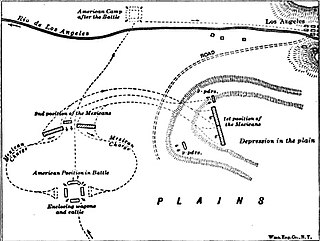
The Battle of Río San Gabriel, fought on 8 January 1847, was a decisive action of the California campaign of the Mexican–American War and occurred at a ford of the San Gabriel River, at what are today parts of the cities of Whittier, Pico Rivera and Montebello, about ten miles south-east of downtown Los Angeles.
The Battle of La Mesa was the final battle of the California Campaign during the Mexican–American War, occurring on January 9, 1847, in present-day Vernon, California, the day after the Battle of Rio San Gabriel. The battle was a victory for the United States Army under Commodore Robert F. Stockton and General Stephen Watts Kearny.

Andrés Pico was a Californio who became a successful rancher, fought in the contested Battle of San Pascual during the Mexican–American War, and negotiated promises of post-war protections for Californios in the 1847 Treaty of Cahuenga. After California became one of the United States, Pico was elected to the state Assembly and Senate. He was appointed as the commanding brigadier general of the state militia during the U.S. Civil War.

The Whittier Narrows is a narrows or water gap in the San Gabriel Valley of Los Angeles County, California, United States, between the Puente Hills to the east and the Montebello Hills to the west. The gap is located at the southern boundary of the San Gabriel Valley, through which the Rio Hondo and the San Gabriel River flow to enter the Los Angeles Basin. The Narrows is located near the convergence of Interstate 605 and California State Route 60.
General José María Flores was a Captain in the Mexican Army and was a member of la otra banda. He was appointed Governor and Comandante Generalpro tem of Alta California from November 1846 to January 1847, and defended California against the Americans during the Mexican–American War.

Pío Pico State Historic Park is the site of El Ranchito, also known as the Pío Pico Adobe or Pío Pico Mansion, the final home of Pío Pico, the last Governor of Alta California under Mexican rule and a pivotal figure in early California history. Located in Whittier, California, at 6003 Pioneer Blvd. near Whittier Blvd. and Interstate 605, it is California Historical Landmark No. 127, listed as "Casa de Governor Pío Pico". Just west of the park is the San Gabriel River. Across the river is the city that bears his name—Pico Rivera. The park consists of the adobe and about three acres of surrounding land.

Captain José Antonio Ezequiel Carrillo (1796–1862) was a Californio politician, ranchero, and signer of the Californian Constitution in 1849. He served three terms as Alcalde of Los Angeles (mayor).
Leonardo Cota (1816–1887) was a Captain with the Californios in the Mexican–American War; and later a Los Angeles County Supervisor.

Rancho La Puente was a ranch in the southern San Gabriel Valley that measured just under 49,000 acres (200 km2), and remained intact from its establishment in the late 1700s as an outpost of Mission San Gabriel until about 1870. By modern landmarks, the ranch extended from San Gabriel River on the west to just west of the 57 Freeway on the east and from Ramona Boulevard/San Bernardino Road on the north to the Puente Hills on the south. All but 40 acres (160,000 m2), which fall within Orange County, are within Los Angeles County. Today, the present communities of Avocado Heights, Bassett, Baldwin Park, San Dimas, Rowland Heights, Hacienda Heights, City of Industry, La Puente, Walnut, Covina, West Covina, and small sections of South El Monte and Irwindale are contained within the old boundaries of Rancho La Puente.
Rancho Paso de Bartolo also called Rancho Paso de Bartolo Viejo was a 10,075-acre (40.77 km2) Mexican land grant in present-day Los Angeles County, California given in 1835 by Governor Jose Figueroa to Juan Crispin Perez. The name refers to a San Gabriel River ford called Paso de Bartolo Viejo. The rancho includes present-day Montebello, Whittier, and Pico Rivera.
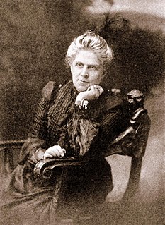
Harriet Williams Russell Strong was an American social activist, inventor, businesswoman, conservationist, and leading figure of the early woman's movement. She has been inducted into the National Women's Hall of Fame and the National Inventors Hall of Fame. Her pioneering innovations in water storage and flood control enabled the construction of the Hoover dam and the All-American Canal.
José Darío María Pico was member of the Pico family of California, an important Californio family to Southern California. He was a soldier in the Company of San Diego since 1782, corporal at Mission San Luis Rey (1798) and sergeant (1805–1818).
The Pico family is a prominent Californio family of Southern California. Members of the family held extensive rancho grants and numerous important positions, including Governor of Alta California, signer of the Constitution of California, and California State Senator, among numerous others. Numerous locations are named after the family across California.
