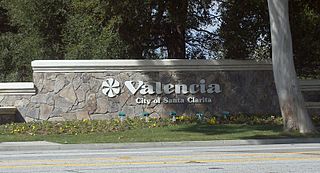
Valencia is a neighborhood in Santa Clarita located within Los Angeles County, California. It is one of the four unincorporated communities that merged to create the city of Santa Clarita in 1987. It is situated in the western part of Santa Clarita, stretching from Lyons Avenue to the south to north of Copper Hill Drive, and from Interstate 5 east to Bouquet Canyon and Seco Canyon Roads. Valencia was founded as a master-planned community with the first development, Old Orchard I, built on Lyons Avenue behind Old Orchard Elementary School.

Metrolink is a commuter rail system in Southern California, serving Los Angeles, Orange, Riverside, San Bernardino, and Ventura counties, as well as to Oceanside in San Diego County. The system consists of eight lines and 69 stations operating on 545.6 miles (878.1 km) of track. This includes Arrow, which Metrolink operates under a contract with the San Bernardino County Transportation Authority (SBCTA).
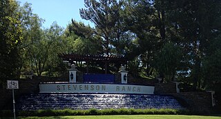
Stevenson Ranch is an unincorporated community in the Santa Clarita Valley of Los Angeles County, California. Stevenson Ranch is set in the foothills of the Santa Susana Mountains and lies west of Interstate 5 and the city of Santa Clarita. Stevenson Ranch encompasses about 6.4 square miles (17 km2). About 1,000 acres (4.0 km2) are set aside as parks, recreation areas, and open space. A master-planned community, it was approved by the county Board of Supervisors in 1985. The population was 20,178 at the time of the 2020 census. For statistical purposes, the Census Bureau has designated it a census-designated place (CDP).
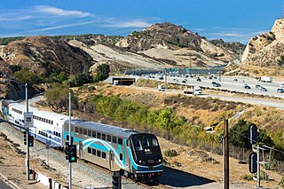
The Antelope Valley Line is a commuter rail line that serves the Northern Los Angeles County area as part of the Metrolink system. The northern segment of the line is rural in character because it travels through the sparsely populated Soledad Canyon between Santa Clarita and Palmdale, serving the small community of Acton along the way. Other portions of its route parallel the former US Route 6, now San Fernando Road and Sierra Highway. This is the only Metrolink line contained entirely within Los Angeles County.

The Alvarado Transportation Center (ATC) is a multimodal transit hub located at 100 1st Street SW in Downtown Albuquerque, New Mexico. The complex was built as a hub for Albuquerque's regional transit system and as a replacement for Albuquerque's previous bus depot and train station. The center serves ABQ RIDE, Amtrak, Greyhound Lines, and the New Mexico Rail Runner Express commuter rail line.

People in the San Francisco Bay Area rely on a complex multimodal transportation infrastructure consisting of roads, bridges, highways, rail, tunnels, airports, seaports, and bike and pedestrian paths. The development, maintenance, and operation of these different modes of transportation are overseen by various agencies, including the California Department of Transportation (Caltrans), the Association of Bay Area Governments, San Francisco Municipal Transportation Agency, and the Metropolitan Transportation Commission. These and other organizations collectively manage several interstate highways and state routes, eight passenger rail networks, eight trans-bay bridges, transbay ferry service, local and transbay bus service, three international airports, and an extensive network of roads, tunnels, and bike paths.

Santa Clarita is a city in northwestern Los Angeles County in the U.S. state of California. With a 2020 census population of 228,673, it is the third-most populous city in Los Angeles County, the 17th-most populous in California, and the 103rd-most populous city in the United States. It is located about 30 miles (48 km) northwest of downtown Los Angeles, and occupies 70.75 square miles (183.2 km2) of land in the Santa Clarita Valley, along the Santa Clara River. It is a classic example of a U.S. edge city, satellite city, or boomburb.

City of Santa Clarita Transit is a local bus service, administered by the City's transit division, that serves the City of Santa Clarita, California and nearby surrounding unincorporated areas. In 2023, the system had a ridership of 2,111,800, or about 12,000 per weekday as of the third quarter of 2024. Daily operations and maintenance of the fleet are under contract with MV Transportation. City of Santa Clarita Transit routes connect with services operated by Metro and Metrolink.

Chatsworth station is an intermodal passenger transport station in the Los Angeles neighborhood of Chatsworth, United States. It is served by Amtrak Pacific Surfliner inter-city rail service, Metrolink Ventura County Line commuter rail service, and the Metro G Line of the Los Angeles Metro Busway bus rapid transit. The station is also served by Los Angeles Metro Bus and Simi Valley Transit local buses, plus Santa Clarita Transit and LADOT Commuter Express regional express bus routes.
Bakersfield station is an intermodal facility in Bakersfield, California. It is the southern terminus of Amtrak California's San Joaquins route, with Amtrak Thruway buses continuing to Amtrak stations and bus stops throughout Southern California and Nevada. The station opened with a celebration on July 4, 2000. It contains an 8,300-square-foot (770 m2) train station with two platforms and three tracks, as well as a 17-bay bus station.

Santa Clarita station is a Metrolink train station in the city of Santa Clarita, California. It is served by Metrolink's Antelope Valley Line between Los Angeles Union Station and Lancaster station. Because the City of Santa Clarita has three other Metrolink stations, this station is sometimes referred to as Soledad Metrolink. City of Santa Clarita Transit offers connecting bus service at the station.

Newhall station is an intermodal hub in the Newhall neighborhood of Santa Clarita, California. The station is served by Metrolink's Antelope Valley Line operating between Los Angeles Union Station and Lancaster, Amtrak Thruway buses connecting to/from San Joaquins trains in Bakersfield, and serves as a transfer point in the City of Santa Clarita Transit bus system.

El Monte Station is a large regional bus station in the city of El Monte, California, United States, adjacent to Interstate 10, serving the Metro J Line, Foothill Transit, Greyhound Lines, and El Monte Transit. It is the Metro J Line's eastern terminus.

The Palmdale Transportation Center is a multi-modal transportation center in the city of Palmdale, California. Featuring a Metrolink rail station, a local bus hub, and commuter bus hub, the center was completely rebuilt in April 2005. It features a "clock tower plaza" which has an enclosed waiting room with concessions and vending, public telephone, restrooms, a bus pass sales office, and security service. The center has four partially enclosed shelters at the bus hub and six partially enclosed shelters for the rail platform. The center also has a large park and ride facility.
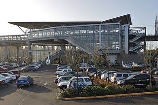
Tukwila International Boulevard station is a light rail station in Tukwila, Washington, United States. It is located between SeaTac/Airport and Rainier Beach stations on the 1 Line from Seattle–Tacoma International Airport to Downtown Seattle. The station consists of two elevated side platforms enclosed within a structure northeast of the interchange of State Route 99 and State Route 518. As one of seven park and rides along the line, it includes 600 parking spaces in two lots.

Kern Transit, formerly Kern Regional Transit, is the operator of mass transportation in Kern County, California. Primarily, it provides inter-regional transportation, connecting outlying regions with the city of Bakersfield. It also provides inter-city transportation within specific regions. Kern (Regional) Transit is operated by the Kern County Department of Roads. The agency was founded in 1981. Its headquarters are located in Bakersfield.

Rapid is a bus rapid transit system serving San Diego County, California. It is part of the San Diego Metropolitan Transit System (MTS). The system mainly operates on the HOV lanes of Interstate 15 and 805. Freeway-level stations are located in the medians of Interstate 15, Park Boulevard, and East Palomar Street.

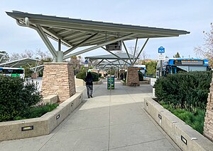
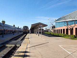
The Vista Canyon Multi-Modal Center, also known as the Vista Canyon Regional Transit Center, is a Metrolink commuter rail station and transport hub in the Canyon Country neighborhood of Santa Clarita, California. It is located along Metrolink's Antelope Valley Line.