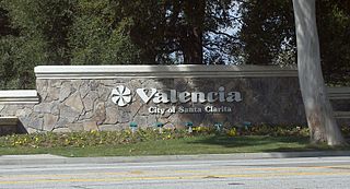
Valencia is a neighborhood in Santa Clarita located within Los Angeles County, California. It is one of the four unincorporated communities that merged to create the city of Santa Clarita in 1987. It is situated in the western part of Santa Clarita, stretching from Lyons Avenue to the south to north of Copper Hill Drive, and from Interstate 5 east to Bouquet Canyon and Seco Canyon Roads. Valencia was founded as a master-planned community with the first development, Old Orchard I, built on Lyons Avenue behind Old Orchard Elementary School.
The Santa Monica Mountains Conservancy is an agency of the state of California in the United States founded in 1980 and dedicated to the acquisition of land for preservation as open space, for wildlife and California native plants habitat Nature Preserves, and for public recreation activities.

The Santa Susana Mountains are a transverse range of mountains in Southern California, north of the city of Los Angeles, in the United States. The range runs east-west, separating the San Fernando and Simi valleys on its south from the Santa Clara River Valley to the north and the Santa Clarita Valley to the northeast. The Oxnard Plain is to the west of the Santa Susana Mountains.

Chino Hills State Park is a state park of California, in the United States. It is located in the Chino Hills, foothills of the Santa Ana Mountains. It is a critical link in the Chino–Puente Hills wildlife corridor, and a major botanical habitat reserve for resident and migrating wildlife.

The Santa Clarita Valley (SCV) is part of the upper watershed of the Santa Clara River in Southern California. The valley was part of the 48,612-acre (19,673 ha) Rancho San Francisco Mexican land grant. Located in Los Angeles County, its main population center is the city of Santa Clarita which includes the communities of Canyon Country, Newhall, Saugus, and Valencia. Adjacent unincorporated communities include Castaic, Stevenson Ranch, Val Verde, and the unincorporated parts of Valencia.
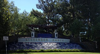
Stevenson Ranch is an unincorporated community in the Santa Clarita Valley of Los Angeles County, California. Stevenson Ranch is set in the foothills of the Santa Susana Mountains and lies west of Interstate 5 and the city of Santa Clarita. Stevenson Ranch encompasses about 6.4 square miles (17 km2). About 1,000 acres (4.0 km2) are set aside as parks, recreation areas, and open space. A master-planned community, it was approved by the county in 1987. The population was 20,178 at the time of the 2020 census. For statistical purposes, the Census Bureau has designated it a census-designated place (CDP).

The Simi Hills are a low rocky mountain range of the Transverse Ranges in eastern Ventura County and western Los Angeles County, of southern California, United States.

Canyon Country is a neighborhood in the eastern part of the city of Santa Clarita, in northwestern Los Angeles County, California, United States. It lies along the Santa Clara River between the Sierra Pelona Mountains and the San Gabriel Mountains. It is the most populous of Santa Clarita's four neighborhoods.

The Santa Monica Mountains National Recreation Area is a United States national recreation area containing many individual parks and open space preserves, located primarily in the Santa Monica Mountains of Southern California. The SMMNRA is in the greater Los Angeles region, with two thirds of the parklands in northwest Los Angeles County, and the remaining third, including a Simi Hills extension, in southeastern Ventura County.

The Topatopa Mountains are a mountain range in Ventura County, California, north of Ojai, Santa Paula, and Fillmore. They are part of the Transverse Ranges of Southern California.
Santa Clarita is a city in northwestern Los Angeles County in the U.S. state of California. With a 2020 census population of 228,673, it is the third-largest city by population in Los Angeles County, the 17th-largest in California, and the 99th-largest city in the United States. It is located about 30 miles (48 km) northwest of downtown Los Angeles, and occupies 70.75 square miles (183.2 km2) of land in the Santa Clarita Valley, along the Santa Clara River. It is a classic example of a U.S. edge city, satellite city, or boomburb.

The Sierra Pelona, also known as the Sierra Pelona Ridge or the Sierra Pelona Mountains, is a mountain ridge in the Transverse Ranges in Southern California. Located in northwest Los Angeles County, the ridge is bordered on the north by the San Andreas fault and lies within and is surrounded by the Angeles National Forest.

Mentryville was an oil drilling town in the Santa Susana Mountains in Los Angeles County, California, USA. It was started by Charles Alexander Mentry in the 1870s around the newly discovered oil reserves in that area. The first oil strike was on September 26, 1876. The town is located at the terminus of Pico Canyon Road, four miles west of the Lyons Avenue exit from I-5 in Santa Clarita. It is currently a part of Stevenson Ranch.
Rancho Santa Maria de Los Peñasquitos was a 8,486-acre (34.34 km2) Mexican land grant in present-day southwestern San Diego County, California given in 1823 to Francisco María Ruiz. The name means "Saint Mary of the Little Cliffs". It encompassed the present-day communities of Mira Mesa, Carmel Valley, and Rancho Peñasquitos in northern San Diego city, and was inland from the Torrey Pines State Natural Preserve bluffs.

Well No. 4, Pico Canyon Oilfield, located about seven miles (11 km) west of Newhall, California, in the Santa Susana Mountains, was the first commercially successful oil well in the Western United States and is considered the birthplace of California's oil industry. Drilled in 1876, it turned nearby Newhall into a boomtown and also spawned a smaller boomtown called Mentryville adjacent to the drilling site. Well No. 4 continued in operation for 114 years until it was capped in 1990. The site was designated a National Historic Landmark in 1966, and the Mentryville ghost town is now open to the public as a historic park.

Placerita Canyon State Park is a California State Park located on the north slope of the western San Gabriel Mountains, in an unincorporated rural area of Los Angeles County, near the city of Santa Clarita. The park hosts a variety of historic and natural sites, as well as serving as a trailhead for several hiking trails leading into the San Gabriel Mountains.
Valencia is an unincorporated community in northwestern Los Angeles County, California. This area, with major commercial and industrial parks, straddles State Route 126 and the Santa Clara River.
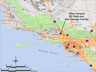
The Aliso Canyon Oil Field is an oil field and natural gas storage facility in the Santa Susana Mountains in Los Angeles County, California, north of the Porter Ranch neighborhood of the City of Los Angeles. Discovered in 1938 and quickly developed afterward, the field peaked as an oil producer in the 1950s, but has remained active since its discovery. One of its depleted oil and gas producing formations, the Sesnon-Frew zone, was converted into a gas storage reservoir in 1973 by the Southern California Gas Company, the gas utility servicing the southern half of California. This reservoir is the second-largest natural gas storage site in the western United States, with a capacity of over 86 billion cubic feet of natural gas. Currently it is one of four gas storage facilities owned by Southern California Gas, the others being the La Goleta Gas Field west of Santa Barbara, Honor Rancho near Newhall, and Playa del Rey.

The Honor Rancho Oil Field is an approximately 600-acre oil field and natural gas storage facility in Los Angeles County, California, on the northern border of the Valencia neighborhood of Santa Clarita, near the junction of Interstate 5 and westbound California State Route 126. Discovered in 1950 and quickly developed, the field's oil production peaked in the 1950s, but remains productive in 2016. In 1975 Southern California Gas Company (SoCalGas), the gas utility serving Southern California, began using one of its depleted oil producing zones, the Wayside 13 zone, as a gas storage reservoir, and it became the second-largest in their inventory after the Aliso Canyon gas storage facility. The field shares part of its extent with the Peter J. Pitchess Detention Center, which includes a maximum-security prison.


