Sierra Pelona Ridge

Last updated
Sierra Pelona
Sierra Pelona Mountains
Sierra Pelona Mountains.JPG
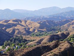
View from Santa Clarita
Highest point
Peak Burnt Peak [1]
Elevation 5,791 ft (1,765 m)
Coordinates 34°40′57″N118°34′36″W / 34.6825°N 118.5768°W / 34.6825; -118.5768 Coordinates: 34°40′57″N118°34′36″W / 34.6825°N 118.5768°W / 34.6825; -118.5768
Naming
Etymology Spanish for "Bald Mountains"
Geography
Relief map of California.png
Red triangle with thick white border.svg
Sierra Pelona
Location of Sierra Pelona Ridge in California [2]
Location Los Angeles County, California, U.S.
Parent range Transverse Ranges

The Sierra Pelona, also known as the Sierra Pelona Ridge [2] or the Sierra Pelona Mountains, is a mountain ridge in the Transverse Ranges in Southern California. [3] Located in northwest Los Angeles County, the ridge is bordered on the north by the San Andreas fault and lies within and is surrounded by the Angeles National Forest.

Contents

Geography

The Sierra Pelona Mountains lie northwest of the San Gabriel Mountains, which are divided by the wide Soledad Canyon formation. The mountains are flanked to the south by the Santa Clarita Valley and separated from the Antelope Valley and the Mojave Desert to the north by the San Andreas Fault. Toward the southeast lie Vasquez Rocks, thrust up by the fault. The Tejon Pass separates the Sierra Pelonas, the San Emigdios the Tehachapis, and the Topatopa Mountains near Gorman and Lebec.

Within the Sierra Pelonas lie the rural areas of Neenach, Three Points, Lake Hughes, Elizabeth Lake, Acton, Agua Dulce and Green Valley. The cities of Santa Clarita, Palmdale, and Lancaster are located at the base of the mountains.

Climate

The climate of the mountains is a Mediterranean climate. Summers are mostly dry except for occasional thunderstorms, and winters comparatively cold and wet. Snowfall is infrequent due to the relatively low elevations of mountains within this ridge, with only the few tallest peaks regularly receiving snowfall during the winter.

Ecology

Mainly the ridge falls under the California montane chaparral and woodlands ecoregion, excepting the northeastern flank's gradual slope into the Antelope Valley near Palmdale where the ecology transitions to that of the Mojave Desert. The mountains are primarily covered in short grasses, scrub oak trees, yucca, and other chaparral shrubs. The ridge is prone to wildfires in the summer and fall, especially when the Santa Ana winds blow in from the Antelope Valley.

Hydrology

Aerial view of the Sierra Pelona Mountains and San Andreas Fault Sierra Pelona Mountains2015.jpg
Aerial view of the Sierra Pelona Mountains and San Andreas Fault

Three major tributaries of the Santa Clara River and numerous minor watercourses and washes drain the ridge: Castaic Creek, San Francisquito Creek, and Bouquet Creek.

Three sag ponds nestle within the narrow valley that divides the mountains from the Antelope Valley: Hughes Lake, Munz Lakes, and Elizabeth Lake.

Human history

Native American habitation

The Native population of California in the Sierra Pelona and Santa Susana Mountains included the Tataviam and Serrano people. They traded with the Tongva and Chumash to the south and west, until the Spanish colonization of the Americas relocated them from their homelands.

18th and 19th centuries

The San Francisquito Canyon, which runs north-south through the mountains, served as a major wagon route between the Antelope and San Fernando Valleys. This corridor summited at San Francisquito Pass and was part of the El Camino Viejo - an alternate land route to the El Camino Real for reaching northern Spanish and Mexican colonial Alta California - as well as the Butterfield Overland Mail route.

20th century

The Ridge Route, a landmark two-lane highway that connected Los Angeles to the rest of California, was built along the western flank of the ridge and was completed in 1915. It was later bypassed by the Ridge Route Alternate (US 99) in 1930, itself superseded by Interstate 5 completed in 1971.

The rapid development of Southern California throughout the 20th century saw construction of the Los Angeles Aqueduct and five separate reservoirs to supply water to the region: Castaic Lake, Bouquet Reservoir, Drinkwater Reservoir, and Dry Canyon Reservoir and the St. Francis Reservoir, both now drained and destroyed.

Highest peaks

Burnt Peak is the tallest mountain in the Sierra Pelona Mountains. Burnt peak from santa clarita.JPG
Burnt Peak is the tallest mountain in the Sierra Pelona Mountains.

Adjacent landforms


Related Research Articles

<span class="mw-page-title-main">San Gabriel Mountains</span> Mountain range of the Transverse Ranges in California, United States

The San Gabriel Mountains are a mountain range located in northern Los Angeles County and western San Bernardino County, California, United States. The mountain range is part of the Transverse Ranges and lies between the Los Angeles Basin and the Mojave Desert, with Interstate 5 to the west and Interstate 15 to the east. The range lies in, and is surrounded by, the Angeles and San Bernardino National Forests, with the San Andreas Fault as its northern border.

<span class="mw-page-title-main">Santa Clarita Valley</span> Valley in Los Angeles County, California, United States

The Santa Clarita Valley (SCV) is part of the upper watershed of the Santa Clara River in Southern California. The valley was part of the 48,612-acre (19,673 ha) Rancho San Francisco Mexican land grant. Located in Los Angeles County, its main population center is the city of Santa Clarita which includes the communities of Canyon Country, Newhall, Saugus, and Valencia. Adjacent unincorporated communities include Castaic, Stevenson Ranch, Val Verde, and the unincorporated parts of Valencia.

<span class="mw-page-title-main">California State Route 14</span> State highway in Los Angeles and Kern counties in California, United States

State Route 14 is a north–south state highway in the U.S. state of California that connects Los Angeles to the northern Mojave Desert. The southern portion of the highway is signed as the Antelope Valley Freeway. The route connects Interstate 5 on the border of the city of Santa Clarita to the north and the Los Angeles neighborhoods of Granada Hills and Sylmar to the south, with U.S. Route 395 (US 395) near Inyokern. Legislatively, the route extends south of I-5 to SR 1 in the Pacific Palisades area of Los Angeles; however, the portion south of the junction with I-5 has not been constructed. The southern part of the constructed route is a busy commuter freeway serving and connecting the cities of Santa Clarita, Palmdale, and Lancaster to the rest of the Greater Los Angeles area. The northern portion, from Vincent to US 395, is legislatively named the Aerospace Highway, as the highway serves Edwards Air Force Base, once one of the primary landing strips for NASA's Space Shuttle, as well as the Naval Air Weapons Station China Lake that supports military aerospace research, development and testing. This section is rural, following the line between the hot Mojave desert and the forming Sierra Nevada mountain range. Most of SR 14 is loosely paralleled by a rail line originally built by the Southern Pacific Railroad, and was once the primary rail link between Los Angeles and Northern California. While no longer a primary rail line, the southern half of this line is now used for the Antelope Valley Line of the Metrolink commuter rail system.

<span class="mw-page-title-main">Tehachapi Mountains</span> Mountain range of the Transverse Ranges in California, United States

The Tehachapi Mountains are a mountain range in the Transverse Ranges system of California in the Western United States. The range extends for approximately 40 miles (64 km) in southern Kern County and northwestern Los Angeles County and form part of the boundary between the San Joaquin Valley and the Mojave Desert.

<span class="mw-page-title-main">Tejon Pass</span> Mountain pass in California, US

The Tejon Pass, previously known as Portezuelo de Cortes, Portezuela de Castac, and Fort Tejon Pass is a mountain pass between the southwest end of the Tehachapi Mountains and northeastern San Emigdio Mountains, linking Southern California north to the Central Valley. Both the pass and the grade north of it to the Central Valley is commonly referred to as "the Grapevine". It has been traversed by major roads such as the El Camino Viejo, the Stockton – Los Angeles Road, the Ridge Route, U.S. Route 99, and now Interstate 5.

<span class="mw-page-title-main">Ridge Route</span> Historical highway connecting Los Angeles County and Kern County via Tejon Pass in California

The Ridge Route, officially the Castaic–Tejon Route, was a two-lane highway between Los Angeles County and Kern County, California. Opened in 1915 and paved with concrete between 1917 and 1921, the road was the first paved highway directly linking the Los Angeles Basin with the San Joaquin Valley over the Tejon Pass and the rugged Sierra Pelona Mountains ridge south of Gorman. Much of the old road runs through the Angeles National Forest, and passes many historical landmarks, including the National Forest Inn, Reservoir Summit, Kelly's Half Way Inn, Tumble Inn, and Sandberg's Summit Hotel. North of the forest, the Ridge Route passed through Deadman's Curve before ending at Grapevine.

<span class="mw-page-title-main">Pyramid Lake (Los Angeles County, California)</span> Reservoir in Los Angeles County, California, United States

Pyramid Lake is a reservoir formed by Pyramid Dam on Piru Creek in the eastern San Emigdio Mountains, near Castaic, Southern California. It is a part of the West Branch California Aqueduct, which is a part of the California State Water Project. Its water is fed by the system after being pumped up from the San Joaquin Valley and through the Tehachapi Mountains.

<span class="mw-page-title-main">Soledad Canyon</span> Canyon in Los Angeles County, California, United States

Soledad Canyon is a long narrow canyon/valley located in Los Angeles County, California between the cities of Palmdale and Santa Clarita. It is a part of the Santa Clara River Valley, and extends from the top of Soledad Pass to the open plain of the valley in Santa Clarita. The upstream section of the Santa Clara River runs through it.

<span class="mw-page-title-main">San Francisquito Canyon</span> Canyon along San Francisquito Creek in the Sierra Pelona of California, United States

San Francisquito Canyon is a canyon created through erosion of the Sierra Pelona Mountains by the San Francisquito Creek, in Los Angeles County, Southern California.

<span class="mw-page-title-main">Area code 661</span> Area code in central and southern California, United States

Area code 661 is a California telephone area code that covers the majority of Kern County, as well as part of Los Angeles County, Santa Barbara County, and Tulare County. It was split from area code 805 on February 13, 1999.

<span class="mw-page-title-main">San Emigdio Mountains</span> Mountain range of the Transverse Ranges in California, United States

The San Emigdio Mountains are a part of the Transverse Ranges in Southern California, extending from Interstate 5 at Lebec and Gorman on the east to Highway 33–166 on the west. They link the Tehachapis and Temblor Range and form the southern wall of the San Joaquin Valley. The range is named after Emygdius, an early Christian martyr.

<span class="mw-page-title-main">Topatopa Mountains</span> Mountain range of the Transverse Ranges in California, United States

The Topatopa Mountains are a mountain range in Ventura County, California, north of Ojai, Santa Paula, and Fillmore. They are part of the Transverse Ranges of Southern California.

<span class="mw-page-title-main">Castaic Creek</span> Tributary of the Santa Clara River in California, United States

Castaic Creek is a 25.0-mile-long (40.2 km) stream in the Sierra Pelona Mountains, in northeastern Los Angeles County, California. It is a tributary of the Santa Clara River.

<span class="mw-page-title-main">Elizabeth Lake (Los Angeles County, California)</span> Intermittent lake in Elizabeth Lake, California

Elizabeth Lake is a natural sag pond that lies directly on the San Andreas Fault in the northern Sierra Pelona Mountains, in northwestern Los Angeles County, southern California. The lake has been dry since 2013 because of prolonged drought.

<span class="mw-page-title-main">San Francisquito Creek (Santa Clara River tributary)</span> Tributary of the Santa Clara River in California, United States

San Francisquito Creek, in Los Angeles County, is a tributary stream of the Santa Clara River. It drains the south facing slopes of the Sierra Pelona Mountains of the San Gabriel Mountains within the Transverse Range of California, United States.

San Francisquito Pass is a mountain pass in the Sierra Pelona Mountains, located northeast of Green Valley and Santa Clarita, in northern Los Angeles County, California.

<span class="mw-page-title-main">Peace Valley (California)</span> Valley in Los Angeles County, California

Peace Valley is a valley in the northwestern corner of Los Angeles County, California, running northeast−southeast along the San Andreas Fault and a section of Interstate 5 near Tejon Pass. The unincorporated community of Gorman is located within the valley.

Mud Spring, formerly called Aquaje Lodoso, is a spring and historic site in the western Antelope Valley, within northern Los Angeles County, southern California.

<span class="mw-page-title-main">Soledad Pass</span> Mountain pass over the Sierra Pelona and San Gabriel Mountains in Southern California, United States

Soledad Pass, elevation 3,209 ft (978 m), is a mountain pass in northern Los Angeles County, California.

<span class="mw-page-title-main">Dry Canyon Reservoir</span> Reservoir in Santa Clarita, California

Dry Canyon Reservoir is a small reservoir formed by an embankment dam on Dry Canyon Creek in the foothills of the Sierra Pelona Mountains of northern Los Angeles County, California, just north of the city of Santa Clarita. It was designed as a part of the Los Angeles Aqueduct system.

References

  1. "Burnt Peak". Peakbagger.com.
  2. 1 2 "Sierra Pelona Ridge". Geographic Names Information System . United States Geological Survey, United States Department of the Interior . Retrieved 2019-10-27.
  3. U.S. Geological Survey Geographic Names Information System: San Gabriel Mountains

See also