Three Points, California

Last updated

Three Points
Three-Points-Welcome.jpg
Three Points welcome sign and fire-burned trees
USA California location map.svg
Red pog.svg
Three Points
Usa edcp location map.svg
Red pog.svg
Three Points
Coordinates: 34°44′09″N118°35′55″W / 34.7358155°N 118.5986976°W / 34.7358155; -118.5986976
Country Flag of the United States.svg United States
State Flag of California.svg  California
County Los Angeles
Time zone UTC-8 (Pacific)
  Summer (DST) UTC-7 (Pacific Daylight Time)
ZIP code
93532, served by Lake Hughes
Area code 661

Three Points is a scenic, sparsely populated unincorporated community at the northwestern edge of Los Angeles County, in the northern Sierra Pelona Mountains foothills and southwest of the Antelope Valley in Southern California, United States. [1]

Contents

Geography

The settlement is on the northern edge of the Angeles National Forest, [2] on the east side of Oakgrove Canyon where it opens out into Pine Canyon, 17.5 miles (28 km) north of Castaic. [3] Its elevation is 3,424 feet. [4]

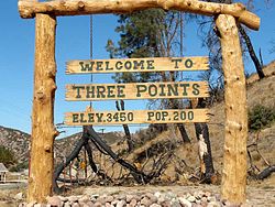
A roadside welcome sign said in 1991 that the Three Points population was 150. [5] In 2008 a newer sign gave the population as 200.

Three Points and Lake Hughes are essentially just wide spots in the road, a few homes and businesses scattered along a dry, brushy gully that marks the course of the San Andreas fault. The combined population of the two communities is about 500.

Los Angeles Times, June 16, 1991 [5]

History

1880s — 1970s

Three Points was homesteaded in 1892 by the Lafferty family, 83-year-old Laura May Lafferty told a reporter in 1991. Her grandmother acted as a midwife, and her father, Ben Cherbbono, was a French Canadian muleskinner who led a team that helped grade the Ridge Route highway in the early part of the 20th century. Gookins Lake in the area was named after her mother's family, she said. [5]

In those days, Three Points was graced with a one-room schoolhouse, Pine Canyon School, where in 1953 Mrs. Lillie Knighton taught children aged 6 to 14; in midwinter, a “huge pot-bellied stove . . . hissed with heat.” [6] The school also acted as a community center; movies related to classwork were shown each Thursday night, open to adults. [6]

Apart from the school, a tavern variously called the Three Point Cafe, Maxine's, and Nancy's Up the Road Cafe, was another center of social life. Bert Gookins was the first owner and builder — sometime in 1912, or maybe 1924, Bert Hart, Gookins’ grandson, recalled. It was a grocery store once, Hart said, and perhaps the restaurant and bar were added in the 1930s or 1940s. [1] The building was occasionally occupied by a traveling dentist who used a foot-powered drill. [5]

1980s on

Former cafe was turned into a private residence. Three-Points-Ex-Cafe.jpg
Former cafe was turned into a private residence.
Grain silos south of the Three Points settlement, Three-Points-Tanks.jpg
Grain silos south of the Three Points settlement,

Michael and Anita Felix bought the cafe in 1984 with the idea of using its park-like grounds for special events. Two years later, Anita had a heart attack and so the Felixes began leasing it to other operators. [1] When Maxine Martin had it in 1991 it was a combination bar, restaurant, social club and video-rental store featuring a decor that included

a jukebox, animal traps, rattlesnake skins, guns, old photographs, dollar bills pinned to the wall, a bottle of pickled pig feet and a sign that says “All tabs must be paid by the end of the month.” [5]

In November 1994 the Felixes resumed managing the cafe — but they opened it only on Saturdays and Sundays, and soon thereafter they put it up for sale. [1]

In 2008 it was a private residence: An unusable gasoline pump in front was purely decorative, and the only sign of commerce was an outside vending machine that dispensed bottled water.

Government

As an unincorporated community, there is no local government, but there is a Three Points–Liebre Mountain Town Council, which in March 2009 was working on a community standards district document and on emergency preparedness. [7]

Education

There is no longer a public school in the settlement. Three Points is part of the Westside Union School District of West Lancaster, which operates Del Sur, Joe Walker, Hill View, Cottonwood, Rancho Vista, Sundown, Valley View, Leona Valley, and Quartz Hill schools, through the eighth grade.

The community is within the Antelope Valley Union High School District and the Antelope Valley Community College District.

Library

The Los Angeles County's public library sends its Antelope Valley bookmobile to Three Points from 9:30 to 11:30 a.m. one day a week. [8]

Fire danger

Three Points was settled in a wooded valley shrouded in volatile pine trees, near a mountain fittingly named Burnt Peak, [3] and the town has been threatened by wildfires many times over the decades. The earliest story about Three Points in the Los Angeles Times, the closest metropolitan newspaper to the settlement, is dated August 24, 1927, and, like many such articles thereafter, it was reporting on a massive fire in the forested area.

AID SENT IN BRUSH FIRE : Blaze Unchecked on Ridge Route Hundred Men and Supplies Rush to Help 700 Already on Job Flames Advance to Three Points in Pine Canyon; No Lives Menaced. [9]

Twenty-two years later, in 1949, another fire in the canyon made the news:

A freakish south-southeast wind which sprang up suddenly yesterday afternoon sent the Sawmill Mountain fire in the Angeles National Forest raging out of control again threatening 75 homes in the Three Points settlement, 16 miles west of Lake Hughes.

In July 2004, the Times reported:

two houses burned in Three Points, a place defined by the only business in town, a little red-shingled restaurant named the Three Point Cafe. A third house in the area burned Thursday. [2]

Related Research Articles

<span class="mw-page-title-main">Los Angeles County, California</span> Most populous county in the United States and in California

Los Angeles County, officially the County of Los Angeles, and sometimes abbreviated as L.A. County, is the most populous county in the United States, with 9,861,224 residents estimated in 2022. Its population is greater than that of 40 individual U.S. states. Comprising 88 incorporated cities and many unincorporated areas within a total area of 4,083 square miles (10,570 km2), it is home to more than a quarter of Californians and is one of the most ethnically diverse U.S. counties. The county's seat, Los Angeles, is the second most populous city in the United States, with about 3.9 million residents. Being the home of the U.S. motion-picture industry, since its inception in the early 20th century, has given the county global prominence.

<span class="mw-page-title-main">San Gabriel Mountains</span> Mountain range of the Transverse Ranges in California, United States

The San Gabriel Mountains are a mountain range located in northern Los Angeles County and western San Bernardino County, California, United States. The mountain range is part of the Transverse Ranges and lies between the Los Angeles Basin and the Mojave Desert, with Interstate 5 to the west and Interstate 15 to the east. The range lies in, and is surrounded by, the Angeles and San Bernardino National Forests, with the San Andreas Fault as its northern border.

<span class="mw-page-title-main">Santa Clarita Valley</span> Valley in Los Angeles County, California, United States

The Santa Clarita Valley (SCV) is part of the upper watershed of the Santa Clara River in Southern California. The valley was part of the 48,612-acre (19,673 ha) Rancho San Francisco Mexican land grant. Located in Los Angeles County, its main population center is the city of Santa Clarita which includes the communities of Canyon Country, Newhall, Saugus, and Valencia. Adjacent unincorporated communities include Castaic, Stevenson Ranch, Val Verde, and the unincorporated parts of Valencia.

<span class="mw-page-title-main">California State Route 14</span> State highway in Los Angeles and Kern counties in California, United States

State Route 14 is a north–south state highway in the U.S. state of California that connects Los Angeles to the northern Mojave Desert. The southern portion of the highway is signed as the Antelope Valley Freeway. The route connects Interstate 5 on the border of the city of Santa Clarita to the north and the Los Angeles neighborhoods of Granada Hills and Sylmar to the south, with U.S. Route 395 (US 395) near Inyokern. Legislatively, the route extends south of I-5 to SR 1 in the Pacific Palisades area of Los Angeles; however, the portion south of the junction with I-5 has not been constructed. The southern part of the constructed route is a busy commuter freeway serving and connecting the cities of Santa Clarita, Palmdale, and Lancaster to the rest of the Greater Los Angeles area. The northern portion, from Vincent to US 395, is legislatively named the Aerospace Highway, as the highway serves Edwards Air Force Base, once one of the primary landing strips for NASA's Space Shuttle, as well as the Naval Air Weapons Station China Lake that supports military aerospace research, development and testing. This section is rural, following the line between the hot Mojave desert and the forming Sierra Nevada mountain range. Most of SR 14 is loosely paralleled by a rail line originally built by the Southern Pacific Railroad, and was once the primary rail link between Los Angeles and Northern California. While no longer a primary rail line, the southern half of this line is now used for the Antelope Valley Line of the Metrolink commuter rail system.

<span class="mw-page-title-main">Ridge Route</span> Historical highway connecting Los Angeles County and Kern County via Tejon Pass in California

The Ridge Route, officially the Castaic–Tejon Route, was a two-lane highway between Los Angeles County and Kern County, California. Opened in 1915 and paved with concrete between 1917 and 1921, the road was the first paved highway directly linking the Los Angeles Basin with the San Joaquin Valley over the Tejon Pass and the rugged Sierra Pelona Mountains ridge south of Gorman. Much of the old road runs through the Angeles National Forest, and passes many historical landmarks, including the National Forest Inn, Reservoir Summit, Kelly's Half Way Inn, Tumble Inn, and Sandberg's Summit Hotel. North of the forest, the Ridge Route passed through Deadman's Curve before ending at Grapevine.

<span class="mw-page-title-main">Neenach, California</span> Unincorporated community in California, United States

Neenach is an agricultural settlement in northwestern Los Angeles County, California, United States, with a population of about 800. It is facing a massive change with the proposed construction of a 23,000-home planned community to its north called Centennial.

<span class="mw-page-title-main">Gorman, California</span> Unincorporated community in California, United States

Gorman is an unincorporated community in northwestern Los Angeles County, California, United States. It is located in Peace Valley south of the Tejon Pass, which links Southern California with the San Joaquin Valley and Northern California. Due to this location, the area has served as a historic travel stop dating back to the indigenous peoples of California. Tens of thousands of motorists travel through Gorman daily on the Golden State Freeway since the highway's completion in the mid-20th Century.

<span class="mw-page-title-main">Lake View Terrace, Los Angeles</span> Neighborhood of Los Angeles in California, United States

Lake View Terrace is a suburban neighborhood in the San Fernando Valley region of the City of Los Angeles, California.

<span class="mw-page-title-main">Canyon Country, Santa Clarita, California</span> Neighborhood of Santa Clarita, California

Canyon Country is a neighborhood in the eastern part of the city of Santa Clarita, in northwestern Los Angeles County, California, United States. It lies along the Santa Clara River between the Sierra Pelona Mountains and the San Gabriel Mountains. It is the most populous of Santa Clarita's four neighborhoods.

<span class="mw-page-title-main">Verdugo Mountains</span> Mountain range of the Transverse Ranges in California, United States

The Verdugo Mountains, also known as the Verdugo Hills or simply The Verdugos, are a small, rugged mountain range of the Transverse Ranges system in Los Angeles County, California. Located just south of the western San Gabriel Mountains, the Verdugo Mountains region incorporates the cities of Burbank, Glendale, Pasadena, and La Cañada Flintridge; the unincorporated communities of Altadena and La Crescenta-Montrose; as well as the City of Los Angeles neighborhood of Sunland-Tujunga.

<span class="mw-page-title-main">Lake Hughes, California</span> Unincorporated community in California, United States

Lake Hughes is an unincorporated community in northern Los Angeles County, California. It is in the Sierra Pelona Mountains, northwest of Palmdale and north of the Santa Clarita Valley, in the Angeles National Forest. It is on the sag pond waters of Lake Hughes and Elizabeth Lake. The community is rural in character, with a population of 649 in 2010, but also has a strong recreational element centered on the three lakes in the vicinity. The community of Elizabeth Lake is located just east of Lake Hughes, sharing the same ZIP code.

<span class="mw-page-title-main">Saugus, Santa Clarita, California</span> Neighborhood of Santa Clarita in Los Angeles, California

Saugus is a neighborhood in Santa Clarita, California. It was one of four communities that merged in 1987 to create the city of Santa Clarita. Saugus includes the central and north-central portions of the city. It is named after Saugus, Massachusetts, the hometown of Henry Newhall, upon whose land the town was originally built.

<span class="mw-page-title-main">Elizabeth Lake (Los Angeles County, California)</span> Intermittent lake in Elizabeth Lake, California

Elizabeth Lake is a natural sag pond that lies directly on the San Andreas Fault in the northern Sierra Pelona Mountains, in northwestern Los Angeles County, southern California.

<span class="mw-page-title-main">Angeles Forest Highway</span> Highway in California

The Angeles Forest Highway is a 25-mile (40 km) road over the San Gabriel Mountains in Los Angeles County, California. It connects the Los Angeles Basin with the Antelope Valley and western Mojave Desert. Maintained by the Los Angeles County Department of Public Works, the highway is designated as County Route N-3 (CR N-3) or Forest Highway 59 (FH 59); the route numbers are unsigned, but noted on many maps.

<span class="mw-page-title-main">Santa Clarita, California</span> City in California, United States

Santa Clarita is a city in northwestern Los Angeles County in the U.S. state of California. With a 2020 census population of 228,673, it is the third-largest city by population in Los Angeles County, the 17th-largest in California, and the 98th-largest city in the United States. It is located about 30 miles (48 km) northwest of downtown Los Angeles, and occupies 70.75 square miles (183.2 km2) of land in the Santa Clarita Valley, along the Santa Clara River. It is a classic example of a U.S. edge city, satellite city, or boomburb.

<span class="mw-page-title-main">Sierra Pelona Ridge</span> Mountain range of the Transverse Ranges in California, United States

The Sierra Pelona, also known as the Sierra Pelona Ridge or the Sierra Pelona Mountains, is a mountain ridge in the Transverse Ranges in Southern California. Located in northwest Los Angeles County, the ridge is bordered on the north by the San Andreas fault and lies within and is surrounded by the Angeles National Forest.

<span class="mw-page-title-main">Devil's Punchbowl (Angeles National Forest)</span> Sandstone rock formation in the San Gabriel Mountains of Southern California

Devil's Punchbowl is a tilted sandstone formation on the northern slopes of the San Gabriel Mountains, in Los Angeles County, California, at an elevation of 4,750 feet (1,450 m).

<span class="mw-page-title-main">California county routes in zone N</span>

There are 9 routes assigned to the "N" zone of the California Route Marker Program, which designates county routes in California. The "N" zone includes county highways lying in Los Angeles and Orange counties.

References

  1. 1 2 3 4 Phil Sneiderman,"End of the Road Remote Cafe Struggles to Stay in Business in Changing Times," Los Angeles Times, April 12, 1995, Document ID 21360071
  2. 1 2 Nikki Usher, Zeke Minaya and Eric Malnic, "Residents in 3 Tiny High Desert Towns on a Nervous Fire Watch," Los Angeles Times. July 16, 2004, page B-1
  3. 1 2 Geographic Names Information System
  4. Topozone maps
  5. 1 2 3 4 5 "L.A.'s Outback Three Point residents are like a family," Los Angeles Times, San Fernando Valley edition, June 16, 1991, page 6>
  6. 1 2 Jerry Hulse, "One-Room School Still Functions," Los Angeles Times, January 26, 1953, page 2
  7. Susan Zahnter, "Three Points," Mountain Enterprise, March 13, 2009
  8. County of Los Angeles Public Library Antelope Valley bookmobile page
  9. Los Angeles Times, August 24, 1927, ProQuest Historical Newspapers database (Document ID: 369121072)