Diamond Bar, California

Last updated

Diamond Bar, California
Diamond Bar City Hills.jpg
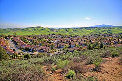
A residential area among the hills of Diamond Bar City
Flag of Diamond Bar, California.gif
Los Angeles County California Incorporated and Unincorporated areas Diamond Bar Highlighted 0619192.svg
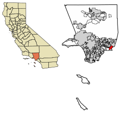
Location of Diamond Bar in Los Angeles County, California
Usa edcp relief location map.png
Red pog.svg
Diamond Bar, California
Location in the United States
Coordinates: 34°0′6″N117°49′15″W / 34.00167°N 117.82083°W / 34.00167; -117.82083
Country Flag of the United States.svg United States
State Flag of California.svg  California
County Los Angeles
Incorporated April 18, 1989 [1]
Named for Diamond Bar Ranch
Government
   Mayor Stan Liu [2]
   Mayor Pro Tem Chia Yu Teng
   City Council Andrew Chou
Ruth M. Low
Steve Tye
Area
[3]
  Total14.88 sq mi (38.53 km2)
  Land14.87 sq mi (38.51 km2)
  Water0.01 sq mi (0.01 km2)  0.04%
Elevation
[4]
696 ft (212 m)
Population
 (2020)
  Total55,072
  Density3,703.56/sq mi (1,429.91/km2)
Time zone UTC−8 (Pacific)
  Summer (DST) UTC−7 (PDT)
ZIP Codes
91765, [5] 91789 (91789 is shared with Walnut, CA)
Area code [6] 909
FIPS code 06-19192
GNIS feature IDs 1660549, 2410334
Website www.diamondbarca.gov

Diamond Bar is a city in eastern Los Angeles County, California, United States. [7] The 2020 census listed a population of 55,072. [8] It is one of a few cities in California with a majority Asian population (59.24% as of 2020) in California. [9] It is named after the "diamond over a bar" branding iron registered in 1918 by ranch owner Frederic E. Lewis (1884–1963). The city features a public Los Angeles County golf course.

Contents

Located at the junction of the Pomona and Orange freeways, Diamond Bar is primarily residential with shopping centers interspersed throughout the city. It is surrounded by the cities of Brea, Walnut, Chino Hills, Pomona, City of Industry, and the unincorporated areas of Rowland Heights and South Diamond Bar. [10]

Northern Diamond Bar is a part of the Pomona Unified School District. [11] Southern Diamond Bar is a part of the Walnut Valley Unified School District. [12] The city is also served by International Polytechnic High School. [13] It also has the first hydrogen fueling station to be built in Southern California, [14] near the South Coast Air Quality Management District building.

History

In 1840, José de la Luz Linares received the 4,340-acre (1,760 ha) Mexican land grant Rancho Los Nogales (Ranch of the Walnut Trees) from Governor Juan Alvarado. The land grant included Brea Canyon and the eastern Walnut Valley. Linares died in 1847, and his widow sold a part of the ranch to Ricardo Vejar for $100 in merchandise, 100 calves, and the assumption of her late husband's debts. Vejar also owned the Rancho San Jose to the east, and acquired the rest of Rancho Nogales over the next 10 years.

However, Vejar's luck did not last that long. As time wore on – and particularly as the United States government took over California – Rancho Los Nogales was divided and sold into multiple land ranches, the largest of which was the Diamond Bar Ranch. At the time, it was one of the largest working cattle ranches in the western U.S. The entire Diamond Bar Ranch was acquired by the Transamerica Corporation in the 1950s for the purpose of developing one of the nation's first master-planned communities. Transamerica gave the Diamond Bar name to its new community and incorporated the ranch's familiar diamond and bar cattle brand into various logos (many of which are still in use today).

The first houses in this development were built in 1959, adjacent to the future location of the Pomona Freeway, which was built through the area ten years later. [15] The town's development and population grew extremely quickly after that.

Transamerica oversaw all development of the community through the 1960s. The Transamerica Corporation divested itself of all its real estate ventures in the 1970s and 1980s. As a result, the Diamond Bar project was sold to multiple developers and much of its initial master plan was not implemented during the latter half of its development in the 1980s.

The City of Diamond Bar was incorporated on April 18, 1989.

Geography

Diamond Bar's main road, Diamond Bar Boulevard, runs along the bottom of the valley that eventually becomes Brea Canyon, and housing developments overlook the boulevard on both sides from surrounding hills. The city lies roughly between the ends of the Chino Fault and the Whittier Fault, both part of the Elsinore Fault Zone.

Positioned in the southeastern corner of the San Gabriel Valley in eastern Los Angeles County, Diamond Bar is approximately 27 miles (43 km) east of Downtown Los Angeles. Neighboring communities include Walnut, Rowland Heights, and Pomona. Diamond Bar is also adjacent to the Inland Empire region, with Chino Hills directly to the east, and to the south of Diamond Bar lie the cities of Brea and La Habra in Orange County.

According to the United States Census Bureau, the city has a total area of 14.9 square miles (39 km2), with no significant bodies of water.

Both the CA-60 Freeway and the CA-57 Freeway run through Diamond Bar. the I-10 Freeway is just north of the city and CA-71 is just east of the city. Major thoroughfares include Grand Avenue, Diamond Bar Boulevard, Pathfinder Road, Golden Springs Drive, and Brea Canyon Road.

Climate

Climate data for Diamond Bar, California
MonthJanFebMarAprMayJunJulAugSepOctNovDecYear
Record high °F (°C)91
(33)
94
(34)
100
(38)
104
(40)
106
(41)
106
(41)
113
(45)
109
(43)
113
(45)
107
(42)
97
(36)
93
(34)
113
(45)
Mean daily maximum °F (°C)67.5
(19.7)
68.8
(20.4)
70.8
(21.6)
76.2
(24.6)
79.1
(26.2)
84.3
(29.1)
90.4
(32.4)
92.3
(33.5)
89.4
(31.9)
80.4
(26.9)
73.7
(23.2)
67.1
(19.5)
78.3
(25.8)
Mean daily minimum °F (°C)40.8
(4.9)
45.8
(7.7)
46.7
(8.2)
50.2
(10.1)
53.7
(12.1)
58.2
(14.6)
62.2
(16.8)
63.1
(17.3)
61.4
(16.3)
55.4
(13.0)
46.6
(8.1)
39.7
(4.3)
52.0
(11.1)
Record low °F (°C)21
(−6)
23
(−5)
26
(−3)
29
(−2)
34
(1)
39
(4)
41
(5)
43
(6)
38
(3)
29
(−2)
24
(−4)
22
(−6)
21
(−6)
Average precipitation inches (mm)3.11
(79)
4.76
(121)
2.63
(67)
1.20
(30)
0.23
(5.8)
0.09
(2.3)
0.00
(0.00)
0.03
(0.76)
0.15
(3.8)
1.05
(27)
1.62
(41)
2.45
(62)
17.32
(440)
Source: [16]

Demographics

Historical population
CensusPop.Note
1970 10,576
1980 28,045165.2%
1990 53,67291.4%
2000 56,2874.9%
2010 55,544−1.3%
2020 55,072−0.8%
U.S. Decennial Census [17]

2020 census

Diamond Bar city, California – Racial and ethnic composition
Note: the US Census treats Hispanic/Latino as an ethnic category. This table excludes Latinos from the racial categories and assigns them to a separate category. Hispanics/Latinos may be of any race.
Race / Ethnicity (NH = Non-Hispanic)Pop 2000 [18] Pop 2010 [19] Pop 2020 [9] % 2000% 2010% 2020
White alone (NH)17,47111,8128,11731.04%21.27%14.74%
Black or African American alone (NH)2,6242,1941,7174.66%3.95%3.12%
Native American or Alaska Native alone (NH)9867560.17%0.12%0.10%
Asian alone (NH)23,92228,88332,62642.50%52.00%59.24%
Pacific Islander alone (NH)6292790.11%0.17%0.14%
Other Race alone (NH)101931790.18%0.17%0.33%
Mixed race or Multiracial (NH)1,6161,2651,4952.87%2.28%2.71%
Hispanic or Latino (any race)10,39311,13810,80318.46%20.05%19.62%
Total56,28755,54455,072100.00%100.00%100.00%

The 2020 United States census reported that Diamond Bar had a population of 55,072. [20] The racial makeup of Diamond Bar was: Asian (61.0%); White (23.3%); Black or African American (4.0%); Hispanics and Latinos of any origin made up 17.8% of the overall population.

The median household income in 2021 was $100,776, with 7.9% of the population living below the poverty line. [21]

2010

The 2010 United States Census [22] reported that Diamond Bar had a population of 55,544. The population density was 3,731.5 inhabitants per square mile (1,440.7/km2). The racial makeup of Diamond Bar was: 29,144 (52.5%) Asian; 18,434 (33.2%) White (21.3% Non-Hispanic White), [23] 2,288 (4.1%) African American; 178 (0.3%) Native American; 106 (0.2%) Pacific Islander; 3,237 (5.8%) from other races; and 2,157 (3.9%) from two or more races. There were 11,138 residents of Hispanic or Latino origin, of any race (20.1%).

The Census reported that 55,415 people (99.8% of the population) lived in households, 102 (0.2%) lived in non-institutionalized group quarters, and 27 (0%) were institutionalized.

There were 17,880 households, out of which 7,008 (39.2%) had children under the age of 18 living in them, 11,792 (66.0%) were opposite-sex married couples living together, 2,165 (12.1%) had a female householder with no husband present, 886 (5.0%) had a male householder with no wife present. There were 496 (2.8%) unmarried opposite-sex partnerships, and 71 (0.4%) same-sex married couples or partnerships. 2,308 households (12.9%) were made up of individuals, and 740 (4.1%) had someone living alone who was 65 years of age or older. The average household size was 3.10. There were 14,843 families (83.0% of all households); the average family size was 3.38.

The age distribution of the population shows 11,895 people (21.4%) under the age of 18, 5,590 people (10.1%) aged 18 to 24, 13,585 people (24.5%) aged 25 to 44, 17,988 people (32.4%) aged 45 to 64, and 6,486 people (11.7%) who were 65 years of age or older. The median age was 41.0 years. For every 100 females, there were 95.2 males. For every 100 females age 18 and over, there were 92.3 males.

There were 18,455 housing units at an average density of 1,239.8 per square mile (478.7/km2), of which 14,513 (81.2%) were owner-occupied, and 3,367 (18.8%) were occupied by renters. The homeowner vacancy rate was 0.9%; the rental vacancy rate was 5.2%. 45,080 people (81.2% of the population) lived in owner-occupied housing units and 10,335 people (18.6%) lived in rental housing units.

2000

As of the census [24] of 2000, there were 56,287 people, 17,651 households, and 14,809 families residing in the city. The population density was 3,813.2 inhabitants per square mile (1,472.3/km2). There were 17,959 housing units at an average density of 1,216.7 per square mile (469.8/km2). The racial makeup of the city was 50.4% Asian, 33.3% White, 3.9% Black or African American, 0.33% Native American, 0.12% Pacific Islander, 7.7% from other races, and 4.21% from two or more races. 18.46% of the population were Hispanic or Latino of any race.

There were 17,651 households, out of which 44.4% had children under the age of 18 living with them, 68.3% were married couples living together, 11.1% had a female householder with no husband present, and 16.1% were non-families. 12.5% of all households were made up of individuals, and 2.7% had someone living alone who was 65 years of age or older. The average household size was 3.18 and the average family size was 3.47.

In the city, the age distribution of the population shows 27.0% under the age of 18, 8.8% from 18 to 24, 29.6% from 25 to 44, 27.2% from 45 to 64, and 7.5% who were 65 years of age or older. The median age was 36 years. For every 100 females, there were 96.0 males. For every 100 females age 18 and over, there were 92.0 males.

According to the 2007 estimate, the median income for a household in the city was $87,224, and the median income for a family was $93,185. Males had a median income of $51,059 versus $37,002 for females. The per capita income for the city was $33,540. About 5.0% of families and 6.0% of the population were below the poverty line, including 5.1% of those under age 18 and 6.1% of those age 65 or over.

According to Mapping L.A., Chinese and Mexican were the most common ancestries. Korea and Taiwan were the most common foreign places of birth in 2000. [25]

Government

Diamond Bar City Council is currently headed by Mayor Stan Liu. The other council members are Andrew Chou, Ruth Low, Chia Yu Teng, and Steve Tye. [2]

Public services

The Los Angeles County Sheriff's Department (LASD) operates the Walnut/Diamond Bar Station in Walnut, serving Diamond Bar. [26]

The Los Angeles County Department of Health Services operates the Pomona Health Center in Pomona, serving Diamond Bar. [27]

County, state, and federal representation

The city is in the First District of the Los Angeles County Board of Supervisors, represented by Hilda Solis. [28]

In the California State Senate, Diamond Bar is in the 30th Senate District , represented by Democrat Bob Archuleta. In the California State Assembly, it is in the 56th Assembly District , represented by Democrat Lisa Calderon. [29]

In the United States House of Representatives, Diamond Bar is in California's 38th congressional district , represented by Democrat Linda Sánchez. [30]

Education

The city is primarily divided into two Blue-ribbon districts. Diamond Bar students north of the city power lines are served by four elementary schools, one middle school, and one high school provided by the Pomona Unified School District. [31] Students south of the power lines running through the city are part of the Walnut Valley Unified School District and are served by nine elementary schools, three middle schools, and three high schools. [31]

Economy

Top employers

According to the city's 2012 Comprehensive Annual Financial Report, [32] the top employers in the city are:

#Employer# of Employees
1 South Coast Air Quality Management District 786
2 Walnut Valley Unified School District 520
3Transcription Services500
4 Travelers 401
5Magan Medical Inc300
6 Pomona Unified School District 210
7Carrescia James-First Team Sns200
8 Diamond Bar High School 200
9First Team Real Estate150
10Baybrook Services Inc120

Notable people

See also

Related Research Articles

<span class="mw-page-title-main">Santa Ana, California</span> City in California, United States

Santa Ana is a city in and the county seat of Orange County, California, United States. Located in the Greater Los Angeles region of Southern California, the city's population was 310,227 at the 2020 census, making Santa Ana the second most populous city in Orange County, the 13th-most populous city in California, and the 65th densest large city in the United States. Santa Ana is a major regional economic and cultural hub for the Orange Coast.

<span class="mw-page-title-main">Los Angeles County, California</span> Most populous county in the US and California

Los Angeles County, officially the County of Los Angeles, and sometimes abbreviated as L.A. County, is the most populous county in the United States, with 9,861,224 residents estimated in 2022. Its population is greater than that of 40 individual U.S. states. Comprising 88 incorporated cities and many unincorporated areas within a total area of 4,083 square miles (10,570 km2), it is home to more than a quarter of Californians and is one of the most ethnically diverse U.S. counties. The county's seat, Los Angeles, is the second most populous city in the United States, with 3,822,238 residents estimated in 2022. The county has been world-renowned as the domicile of the U.S. motion-picture industry since the latter's inception in the early 20th century.

<span class="mw-page-title-main">Avocado Heights, California</span> Census-designated place in California, United States

Avocado Heights is an unincorporated census-designated place (CDP) in the San Gabriel Valley of Los Angeles County, California, United States. It is almost entirely surrounded by the City of Industry with only a small strip of unincorporated Los Angeles County separating it from South El Monte. It is in close proximity to both the Pomona (SR-60) and San Gabriel (I-605) freeways. To the west is the San Gabriel River and the California Country Club. Avocado Heights is approximately 15 miles (24 km) from the downtown Los Angeles Civic Center. The population was 15,411 at the 2010 census, up from 15,148 at the 2000 census.

<span class="mw-page-title-main">Baldwin Park, California</span> City in California, United States

Baldwin Park is a city located in the central San Gabriel Valley region of Los Angeles County, California, United States. As of the 2020 census, the population was 72,176, down from 75,390 at the 2010 census.

<span class="mw-page-title-main">Bell Gardens, California</span> City in California, United States

Bell Gardens is a city in the U.S. state of California in the Los Angeles metropolitan area. Located in Los Angeles County, the city's population was 42,072 at the 2010 census, down from 44,054 at the 2000 census. Bell Gardens is part of the Gateway Cities Region, a largely urbanized region located in southeastern Los Angeles County.

<span class="mw-page-title-main">La Puente, California</span> City in California, United States

La Puente is a city in Los Angeles County, California, United States. The city had a population of 39,816 at the 2010 census and is approximately 20 miles (32 km) east of downtown Los Angeles.

<span class="mw-page-title-main">Pomona, California</span> City in California, United States

Pomona is a city in eastern Los Angeles County, California, United States. Pomona is located in the Pomona Valley, between the Inland Empire and the San Gabriel Valley. At the 2020 census, the city's population was 151,713. The main campus of California State Polytechnic University, Pomona, also known as Cal Poly Pomona, lies partially within Pomona's city limits, with the rest being located in the neighboring unincorporated community of Ramona.

<span class="mw-page-title-main">Rowland Heights, California</span> Unincorporated community in the United States

Rowland Heights is an unincorporated area in and below the Puente Hills in the San Gabriel Valley, in Los Angeles County, California, United States. The population was 48,231 at the 2020 census. Rowland Heights is in the Los Angeles metropolitan area and represented by the County of Los Angeles and is the largest census designated place in Los Angeles County by area and the county's fourth largest CDP by population. The area has a high Taiwanese population and was known as “Little Taipei” in the 1980s and 1990s, when it saw an influx of wealthy immigrants from Taiwan.

<span class="mw-page-title-main">San Dimas, California</span> City in California, United States

San Dimas is a city in the San Gabriel Valley of Los Angeles County, California, United States. At the 2020 census, its population was 34,924. It historically took its name from San Dimas Canyon in the San Gabriel Mountains above the northern section of present-day San Dimas.

<span class="mw-page-title-main">South San Jose Hills, California</span> Census-designated place in California, United States

South San Jose Hills is an unincorporated community and census-designated place in Los Angeles County, California, United States. The population was 20,551 at the 2010 census, up from 20,218 at the 2000 census.

<span class="mw-page-title-main">Valinda, California</span> Census-designated place in California, United States

Valinda is a census-designated place (CDP) in the San Gabriel Valley, in Los Angeles County, California, in the United States. At the 2010 census, the population was 22,822, up from 21,776 at the 2000 census.

<span class="mw-page-title-main">Walnut, California</span> City in California, United States

Walnut is a city in the eastern part of Los Angeles County in the U.S. state of California. According to the 2010 census, the city had a population of 29,172, and the population was estimated to be 29,685 in 2019.

<span class="mw-page-title-main">West Puente Valley, California</span> Census-designated place in California, United States

West Puente Valley is an unincorporated community and census-designated place in Los Angeles County, California, USA, northwest of La Puente. The population was 22,636 at the 2010 census, up from 22,589 at the 2000 census. The community is probably named for its location related to the city of La Puente.

<span class="mw-page-title-main">Whittier, California</span> City in the United States

Whittier is a city in Southern California in Los Angeles County, part of the Gateway Cities. The 14.7-square-mile (38.0 km2) city had 87,306 residents as of the 2020 United States census, an increase of 1,975 from the 2010 census figure. Whittier was incorporated in February 1898 and became a charter city in 1955. The city is named for the Quaker poet John Greenleaf Whittier and is home to Whittier College. The city is surrounded by three unincorporated areas sharing the Whittier name, West Whittier-Los Nietos, South Whittier, and East Whittier, which combined are home to a larger population than Whittier proper.

<span class="mw-page-title-main">Brea, California</span> City in California, United States

Brea is a city in northern Orange County, California. The population as of the 2010 census was 39,282. It is 33 miles (53 km) southeast of Los Angeles. Brea is part of the Los Angeles metropolitan area.

<span class="mw-page-title-main">Fullerton, California</span> City in California, United States

Fullerton is a city located in northern Orange County, California, United States. As of the 2020 census, the city had a total population of 143,617.

<span class="mw-page-title-main">Chino, California</span> City in California, United States

Chino is a city in the western end of San Bernardino County, California, United States, with Los Angeles County to its west and Orange County to its south in the Southern California region.

<span class="mw-page-title-main">Chino Hills, California</span> City in California, United States

Chino Hills is a city located in the southwestern corner of San Bernardino County, California, United States. The city borders Los Angeles County on its northwest side, Orange County to its south and southwest, and Riverside County to its southeast.

<span class="mw-page-title-main">Montclair, California</span> City in California, United States

Montclair is a city in the Pomona Valley, in southwestern San Bernardino County, California, 35 miles (56 km) east of downtown Los Angeles. The population was 37,865 in the 2020 United States Census.

<span class="mw-page-title-main">Pomona Valley</span> Valley in Los Angeles and San Bernardino counties in California

The Pomona Valley is located in the Greater Los Angeles Area between the San Gabriel Valley and San Bernardino Valley in Southern California. The valley is approximately 30 miles (48 km) east of downtown Los Angeles.

References

  1. "California Cities by Incorporation Date". California Association of Local Agency Formation Commissions. Archived from the original (Word) on November 3, 2014. Retrieved August 25, 2014.
  2. 1 2 "Council Members". City of Diamond Bar. Archived from the original on February 6, 2015. Retrieved December 16, 2014.
  3. "2020 U.S. Gazetteer Files". United States Census Bureau. Retrieved October 30, 2021.
  4. "Diamond Bar". Geographic Names Information System . United States Geological Survey, United States Department of the Interior . Retrieved February 26, 2015.
  5. "USPS – ZIP Code Lookup – Find a ZIP+ 4 Code By City Results" . Retrieved January 18, 2007.
  6. "Number Administration System – NPA and City/Town Search Results". Archived from the original on September 26, 2007. Retrieved January 18, 2007.
  7. "Diamond Bar Country". diamonbarcountry.com. Retrieved July 31, 2015.
  8. "Diamond Bar city, California". United States Census Bureau . Retrieved August 5, 2024.
  9. 1 2 "P2: Hispanic or Latino, and Not Hispanic or Latino by Race – 2020: DEC Redistricting Data (PL 94-171) – Diamond Bar city, California". United States Census Bureau.
  10. "Google Maps". Google Maps. Retrieved January 26, 2017.
  11. "Pomona Unified". Edline. Archived from the original on January 28, 2015. Retrieved January 26, 2017.
  12. "Best School Districts for Your Buck in Southern California". NerdWallet. Archived from the original on July 27, 2015. Retrieved July 31, 2015.
  13. "iPoly High School / Homepage". www.ipolyhighschool.org.
  14. "AQMD Celebrates Grand Opening of the First Hydrogen Highway Network Fueling Station in Southern California" (Press release). South Coast Air Quality Management District. August 13, 2004. Archived from the original on May 10, 2008. Retrieved May 10, 2008.
  15. "California State Route 60". AARoads. Retrieved July 31, 2015.
  16. "Diamond Bar, CA Monthly Weather". The Weather Channel . Retrieved June 2, 2020.
  17. "Census of Population and Housing". Census.gov. Retrieved June 4, 2015.
  18. "P004: Hispanic or Latino, and Not Hispanic or Latino by Race – 2000: DEC Summary File 1 – Diamond Bar city, California". United States Census Bureau.
  19. "P2: Hispanic or Latino, and Not Hispanic or Latino by Race – 2010: DEC Redistricting Data (PL 94-171) – Diamond Bar city, California". United States Census Bureau.
  20. "Diamond Bar city, California". Census Bureau QuickFacts. Retrieved December 20, 2023.
  21. "Diamond Bar (city) QuickFacts". US Census Bureau. Archived from the original on July 18, 2015. Retrieved June 22, 2023.
  22. "2010 Census Interactive Population Search: CA – Diamond Bar city". U.S. Census Bureau. Archived from the original on September 23, 2015. Retrieved July 12, 2014.
  23. "Diamond Bar (city) QuickFacts". United States Census Bureau. Archived from the original on July 18, 2015. Retrieved March 15, 2015.
  24. "U.S. Census website". United States Census Bureau . Retrieved January 31, 2008.
  25. "Diamond Bar". Mapping L.A. Retrieved December 20, 2023.
  26. "Walnut/Diamond Bar Station Archived 2010-01-06 at the Wayback Machine ." Los Angeles County Sheriff's Department. Retrieved on January 21, 2010.
  27. "Pomona Health Center." Los Angeles County Department of Health Services. Retrieved on March 27, 2010.
  28. "The First District - Supervisor Hilda L Solis".
  29. "California Districts". UC Regents. Retrieved January 5, 2023.
  30. "California's 38th Congressional District - Representatives & District Map". Civic Impulse, LLC.
  31. 1 2 "Public Schools and Districts Data Files - Schools & Districts (CA Dept of Education)". www.cde.ca.gov. Retrieved February 10, 2017.
  32. "City of Diamond Bar CAFR". Archived from the original on August 26, 2013. Retrieved July 9, 2013.
  33. "Jim Edmonds Stats". Baseball Almanac. Retrieved December 3, 2012.
  34. "SENATOR ROBERT 'BOB' S. HUFF'S BIOGRAPHY". Project Vote Smart. Retrieved December 3, 2012.. Huff was born in Calexico, then moved to Diamond Bar in 1983, at age 30, and as of 2013 still resides there.
  35. "TIFFANY PROFILE". December 17, 2010. Retrieved June 28, 2013.
  36. "KIM, Jay, (1939–)". Biographical Directory of the United States Congress. Retrieved December 7, 2012.
  37. "About Gary". House of Representatives web site. Archived from the original on June 25, 2008. Retrieved June 29, 2008.
  38. "Morgan named U.S. Soccer's Female Athlete of the Year". Inland Valley Daily Bulletin . December 4, 2012. Archived from the original on January 21, 2013. Retrieved December 7, 2012.
  39. 1 2 "1TYM YG BOUNCE". Archived from the original on May 14, 2012. Retrieved December 12, 2012.
  40. Touré (December 14, 2006). "America's Most Lovable Pimp". Rolling Stone . Retrieved January 31, 2017.
  41. "Keith Adam Van Horn". Basketball-Reference.com. Retrieved December 3, 2012.
  42. "Ryan Wendell". Fresno State. Archived from the original on July 22, 2012. Retrieved December 3, 2012.
  43. "Jason Wright – Football bio". nusports.cstv.com. Archived from the original on November 18, 2010. Retrieved August 18, 2020.
  44. "大谷はクラブハウスガイ うれしかった初安打の「革手」 - スポニチ Sponichi Annex 野球".