
The South Bay is a region of the Los Angeles metropolitan area, located in the southwest corner of Los Angeles County. The name stems from its geographic location stretching along the southern shore of Santa Monica Bay. The South Bay contains sixteen cities plus portions of the City of Los Angeles and unincorporated portions of the county. The area is bounded by the Pacific Ocean on the south and west and generally by the City of Los Angeles on the north and east.

Palos Verdes Estates is a coastal city in Los Angeles County, California, United States, situated on the Palos Verdes Peninsula and neighboring Rancho Palos Verdes and Rolling Hills Estates. The city was master-planned by the noted American landscape architect and planner Frederick Law Olmsted Jr. The city is located along the Southern California coastline of the Pacific Ocean.

Rancho Palos Verdes is a coastal city located in south Los Angeles County, California. Incorporated on September 7, 1973, the city has a population of 42,287 as reported in the 2020 United States Census. Rancho Palos Verdes sits atop the bluffs of the Palos Verdes Peninsula, neighboring three other cities in the Palos Verdes Hills, namely Palos Verdes Estates, Rolling Hills, and Rolling Hills Estates. It is known for its extensive nature preserves and hiking trails, school district, as well as high property values.

Rolling Hills is a city on the Palos Verdes Peninsula, in Los Angeles County, California, United States. Rolling Hills is a gated community with private roads with three entry gates. Homes are single-story 19th century California ranch or Spanish haciendas exemplified by architect Wallace Neff. Incorporated in 1957, Rolling Hills maintains a rural and equestrian character, with no traffic lights, multi-acre lots with ample space between homes, and wide equestrian paths along streets and property lines.

Rolling Hills Estates is a city in Los Angeles County, California, United States. On the northern side of the Palos Verdes Peninsula, facing Torrance, Rolling Hills Estates is mostly residential. Incorporated in 1957, Rolling Hills Estates has many horse paths. The population was 8,067 at the 2010 census, up from 7,676 at the 2000 census. In 2018, the population rose to 8,141, and the 2020 census counted 8,280 residents.

The Palos Verdes Peninsula is a peninsula and sub-region of the Los Angeles metropolitan area, located within southwestern Los Angeles County in the U.S. state of California. It is often referred to simply as "Palos Verdes", and is made up of a group of cities in the Palos Verdes Hills, including Palos Verdes Estates, Rancho Palos Verdes, Rolling Hills and Rolling Hills Estates, as well as the unincorporated community of Westfield/Academy Hill. It is located in the South Bay region. The peninsula borders the city of Torrance to its north, the Pacific Ocean is on the west and south, and the Port of Los Angeles is to the east. As of the 2010 Census, the population of the Palos Verdes Peninsula is 65,008.

Frank Lloyd Wright Jr., commonly known as Lloyd Wright, was an American architect, active primarily in Los Angeles and Southern California. He was a landscape architect for various Los Angeles projects (1922–1924), provided the shells for the Hollywood Bowl (1926–1928), and produced the Swedenborg Memorial Chapel at Rancho Palos Verdes, California (1946–1971). His name is frequently confused with that of his more famous father, Frank Lloyd Wright.
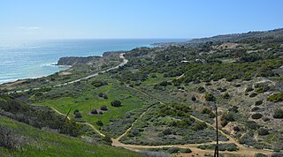
The Portuguese Bend region is the largest area of natural vegetation remaining on the Palos Verdes Peninsula, in Los Angeles County, California. Though once slated for development including the projected route of Crenshaw Boulevard, the area is geologically unstable and is unsuitable for building.

Dudleya virens, the green liveforever or bright green dudleya, is an uncommon species of perennial, succulent plant in the family Crassulaceae, native to several coastal southern California and Baja California locations.
Palos Verdes Peninsula High School is a public high school in Rolling Hills Estates, Los Angeles County, California, United States, in the Los Angeles metropolitan area. As of 2023, it is a top-ranked school in the Los Angeles, CA Metro Area (#16) and California (#42), according to US News & World Report.

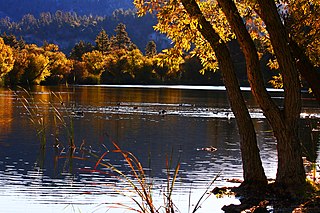
The South Coast Botanic Garden is an 87 acres (35 ha) botanical garden in the Palos Verdes Hills, in an unincorporated area of Los Angeles County, California, United States, about 10 miles (16 km) south of Los Angeles International Airport. It has over 150,000 landscaped plants and trees from approximately 140 families, 700 genera, and 2,000 different species, including flowering fruit trees, Coast Redwoods, Ginkgos and Pittosporum. It is particularly rich in plants from Australia and South Africa. Its gardens include the Water-wise Garden, Herb Garden, English Rose Garden, and Garden of the Senses. A small lake and stream bed attract various birds such as ducks, geese, coots, and herons. Over 300 species of birds have been recorded. The lake is currently empty.
Palos Verdes Peninsula Unified School District (PVPUSD) is a school district headquartered in Palos Verdes Estates, California with facilities in all four cities of the Palos Verdes Peninsula.

The Palos Verdes Library District (PVLD) is an independent special library district serving the residents of the Palos Verdes Peninsula in Southern California. PVLD is governed by a publicly elected Board of Trustees that consists of five members who voluntarily serve without monetary compensation. PVLD's three libraries - Peninsula Center Library, Malaga Cove Library, and Miraleste Library - serve the cities of Palos Verdes Estates, Rancho Palos Verdes, Rolling Hills Estates, and Rolling Hills, California.

Crossosoma californicum, known by the common name California rockflower, is one of only a few species in the flowering plant family Crossosomataceae.
The Palos Verdes Peninsula Transit Authority is the primary provider of mass transportation in the Los Angeles suburbs of Rancho Palos Verdes, Palos Verdes Estates, Rolling Hills, and Rolling Hills Estates, California. Six color routes provide local service, while Routes 225 and 226 both allow for connections in Torrance and Route 226 also continues into the Los Angeles district of San Pedro.
There are 9 routes assigned to the "N" zone of the California Route Marker Program, which designates county routes in California. The "N" zone includes county highways lying in Los Angeles and Orange counties.

The Palos Verdes Peninsula Land Conservancy (PVPLC) is a non-profit organization that is based on the Palos Verdes Peninsula in southwestern Los Angeles County, California.
A. E. Hanson (1893–1986) was an American landscape architect and real estate developer in Southern California. He designed gardens on the campus of the University of Southern California as well as in Bel Air. He developed two gated communities near Los Angeles, California: Rolling Hills and Hidden Hills.
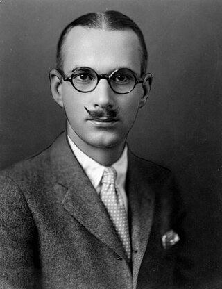
Sumner Spaulding (1892–1952) was an American architect and city planner. He is best known for designing the Harold Lloyd Estate, a.k.a. Greenacres, in Beverly Hills, California, the Catalina Casino in Avalon on Santa Catalina Island, California, and the Malaga Cove Plaza in Palos Verdes Estates, California.


